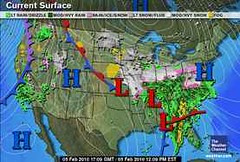
 The Weather Alternative long-range weather forecast for Super Bowl 2010 was posted on November 14, 2009. The forecast was based on the conjunction of Venus and Neptune, which was to be activated the day before the Super Bowl on Feb 6. The forecast called for the possibility of heavy rain over Miami and Florida, which at times can lead to flash flooding. The forecast was pretty close--just off by a day--as the rain heavy rains hit by 5th. The Weather Channel map at left is for February 5th.
It wasn't until February 2nd that conventional forecasters began to see the potential for heavy rain over the Miami area on the 5th and 6th.
 Christmas
The Christmas and New Year's forecasts posted on The Weather Alternative on November 7, 2009 were very successful. We don't have time to go through all of them but here are the most important.
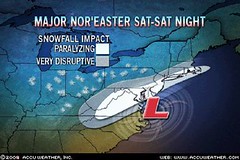
The Weather Alternative forecast for December 20-22 for the East Coast and New England called for a heavy precipitation (which I thought would be rain but most of it was snow) from North Carolina through New England. A low pressure area over North Carolina became a Nor'easter that lashed the forecast area with with wind rain and snow. The Accuweather Map at right shows the low pressure area.
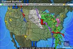 The Weather Alternative forecast for December 24-26 warned that a strong winter storm would cover the area from Michigan to Florida creating major travel problems and airport delays. Special intensity was expected over the Southeast U.S.
The Weather Channel map at left is for December 25th. During this period, a record-setting blizzard hit the northern Plains and moved eastward across the forecast area. The Southeast was hit by flooding downpours, damaging winds, and tornadoes. Strong winds,snow, sleet, freezing rain, and rain hit the Midwest.
 The Weather Alternative forecast for Dec 20-22 also called for an energetic front to hit the West Coast. The Weather Channel map at right is for December 21st. The Weather Channel reported on the 22nd that a potent winter storm is bringing areas of heavy snow to the West today.
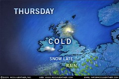 Europe
The Weather Alternative forecast for Europe called for a cold, dry air mass to descend over the United Kingdom between December 22-23. The Accuweather map at left shows the cold forecast for the 23rd.
The Weather Alternative also forecast that a powerful storm system would batter France, Germany, and the surrounding countries on December 24th and 25th. On the 24th, The Weather Underground reported "A strong low pressure system will continue moving eastward from central Europe and extend into eastern Europe. This will spread scattered showers over most of Europe, with snow anticipated at higher elevations. The strongest region of the system will move through Spain and into eastern France and Switzerland by evening. These areas will see periods of heavy rainfall with periods of heavy snow at high elevations of the Alps."
Introduction to the Weather Alternative
How Long-Range Forecasts Are Made
Saint Patrick's Day 2010 Weather Forecast
Greatness
The talent of success is nothing more than doing what you can do well, and doing well whatever you do without thought of fame. If it comes at all it will come because it is deserved, not because it is sought after. --Henry Wadsworth Longfellow
The heights by great men reached & kept
Were not attained by sudden flight,
But they, when their companions slept,
Were toiling upward in the night.
--Henry Wadsworth Longfellow
No comments:
Post a Comment