Click here for July 2006 Hurricane and Severe Weather Outlook.
Here is some commentary on the July 2-4, 2006 forecast. This forecast was prepared between Nov. 16-28, 2005.
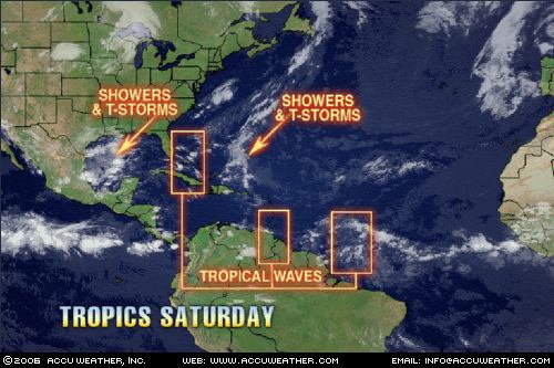
July 2-4Forecast: The tropics may begin to rumble as planetary indicators off the coast of Veracruz, Mexico suggest the possibility of tropical storm formation there.The Arklatex region shows signs of severe weather as moisture from the Gulf of Mexico is pumped into the area.
Results
The July 1, 2006 Accuweather Map above shows the development of thunderstorms and showers off the coast of Veracruz, Mexico. The Mexican Weather Bureau reported the following today:
Amplia zona de inestabilidad convectiva frente a las costas de Veracruz y Tamaulipas se asocia con nublados de convección moderada a fuerte, favoreciendo nublados con chubascos, tormentas y vientos fuertes. El sistema avanza hacia el Noroeste y se encuentra en vigilancia debido a su lenta evolución. (A wide area of convective instability off the coasts of Veracruz and Tamaulipas is asscociated with moderate to strong convection favoring showers, storms, and strong winds. The system is moving toward the Northeast and is being watched for further development.) (Rough translation is mine)
Forecast continues...
The Arklatex region shows signs of severe weather as moisture from the Gulf of Mexico is pumped into the area.

The map to the left (courtesy of Accuweather) shows the tropical moisture being pulled up over Texas and Louisiana.
Here Comes The Rain AgainSunday, July 02, 2006 2:18 PM EDT More News The Texas Gulf Coast, which had torrential rain for a couple of days nearly 2 weeks ago, is in for another bout of heavy, flooding rain over the next couple of days. A tropical low pressure system, which was in the southern Gulf of Mexico a couple of days ago, has been drawn northward. Tropical moisture has been concentrating around this system and, as it continues to be pushed northward, this tropical moisture will be shoved ashore into coastal Texas, resulting in heavy, drenching thunderstorms. The overall movement of this system will be slow, so parts of coastal Texas appear to be in for another thorough soaking. This story by AccuWeather.com Meteorologist Gerald Mohler.
Louisiana and Arkansas are in for some wet weather due to this system and other factors.
1213 PM CDT SUN JUL 2 2006
THIS HAZARDOUS WEATHER OUTLOOK IS FOR SOUTHEAST OKLAHOMA...NORTHEASTTEXAS...SOUTHWEST ARKANSAS...NORTHWEST...AND NORTH CENTRAL LOUISIANA.
HEAVY RAINFALL PRODUCING THUNDERSTORMS WILL BE POSSIBLE SOUTHWEST OFA TYLER TEXAS TO POLLOCK LOUISIANA LINE THROUGH TONIGHT. BECAUSE OF THE ANTICIPATED SLOW MOVEMENT OF THE SHOWERS AND THUNDERSTORMS...LOCALIZED HEAVY DOWNPOURS IN THE STRONGER STORMSMAY RESULT IN THE PONDING OF WATER OVER PARTS OF EAST TEXAS THROUGHCENTRAL LOUISIANA.
157 PM CDT SUN JUL 2 2006
THIS HAZARDOUS WEATHER OUTLOOK IS FOR A LARGE PART OF ARKANSAS..
AN ACTIVE WEATHER PATTERN IS SETTING UP FOR MUCH OF THE UPCOMING WEEK... AN UPPER LEVEL LOWPRESSURE SYSTEM OVER TEXAS WILL SEND UP COPIOUS AMOUNTS OFMOISTURE OVER THE MID SOUTH DURING MUCH OF THE WEEK... THE LARGE AMOUNT OF MOISTURE OVER THE AREA WILL INTERACT WITHDAYTIME HEATING AND THE FRONTAL BOUNDARY. THIS WILL ALLOW SCATTEREDTO NUMEROUS SHOWERS AND THUNDERSTORMS TO DEVELOP THROUGH WEDNESDAY.SOME OF THE STORMS MAY PRODUCE HEAVY RAINFALL. ...THE STORMS WILL HAVE THECAPABILITY OF PRODUCING ONE TO TWO INCHES OF RAIN IN A VERY SHORT PERIOD OF TIME.
No comments:
Post a Comment