Click here for the Introduction to The Weather Alternative
Conventional meteorologists, over the last couple of days, have realized that a potent storm system is taking shape over the Central U.S. This was forecast by The Weather Alternative back in December 2005 and posted this blog on August 24, 2006. The forecast is repeated below.
Forecast
Sept. 21-23:
The insurgence of warm, moist air over the Gulf Coast States from Texas to Florida will act as a potential storm breeder on its journey northward into the central U.S.
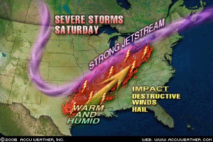 Graphic by Accuweather.com
Sept 21, 2006- The Weather Channel
A soaking inch-plus rain will extend from the Dakotas to the western Great Lakes. Thunderstorms will be ongoing or developing from the eastern sections of the central Plains, across the mid-Mississippi Valley, to the Ohio Valley. With a strong energetic jet stream from Kansas to Lower Michigan, warming temperatures and a plentiful return of moisture from the Gulf, severe thunderstorms with hail, damaging wind gusts and tornadoes will erupt over Iowa, Missouri and Illinois Friday. Winds will be strong and gusty over the northern Plains, Mississippi Valley, western Great Lakes and Ohio Valley.
No comments:
Post a Comment