Click here for the Introduction to The Weather Alternative
The Weather Alternative long-range forecast for Sept 8-9, 2006 called for a stormy period for the U.S. West Coast and Plains. These forecasts were prepared during December 2005.
The Plains
Here are the latest reports from Accuweather .com:
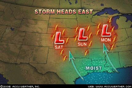 A storm system will take shape today across the west-central Plains and then head northeastward into Illinois by Monday. This storm will tap into moist Gulf of Mexico air, allowing for rain and thunderstorms to spread on eastward with it. In the area just south of the warm front and east of the cold front, enough instability will be around along with favorable jet steam energy to allow for a few storms to be locally severe with gusty winds and hail. The best threat for a severe storm today will be in western Oklahoma and the Texas Panhandle. By tomorrow, the threat will shift into central and eastern Kansas into Missouri, and by Monday into parts of southern Illinois.
The West Coast
Sept 8, 2006- Accuweather
The wildfire danger remains at a critical level in the Northwest interior. A cold front moving into the region will bring cooler temperatures and higher humidity. However, dry thunderstorms developing ahead of the front could spark more fires, and gusty winds associated with the cold front could help to spread existing fires.
A disturbance in the upper levels of the atmosphere has been causing heavy rainfall the past couple of days over the Southwest and southern Rockies.
No comments:
Post a Comment