 explained how
the Venus-Saturn conjunction of October 13th would affect weather conditions over the Northeast U.S.
Forecast
October 12-14
The Venus-Saturn conjunction on the 13th falls in opposition to the degree of the August 28th lunar eclipse. Atmospheric conditions will deteriorate considerably over the Northeast U.S. as low-pressure is drawn to the area. By themselves, this planetary combo signifies heavy downfall and easterly winds. Additional planetary phenomena at this time add intense cold fronts and high winds to the mix, which suggest the possibility of a tropical system.
Results
From Accuweather
Northeast Storm Ramps Up Updated: Thursday, October 11, 2007 9:18 AM
From tonight into Friday, the low pressure center off the East Coast will continue to strengthen as it slides north along Interstate 95 into New England. A soaking rain will pour down on central and upstate New York, New England and the surrounding Canadian provinces as the storm pulls in rich moisture from the Atlantic Ocean. Meanwhile, cold, gusty winds on the backside of the low will put a chill in the air. Motorists should use caution as the combination of wet roads and fallen leaves could create slick driving conditions.
Other Long-range Forecast Results
The following forecast was posted on September 22nd:
Forecast
Oct 9-13
A cold front pushing into the southern Mississippi Valley will bring windy conditions to the area and possibly generate strong storms.
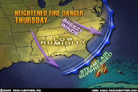
 The Accuweather map of October 8th at left shows the awaited cold front pushing into the southern U.S reaching the Gulf Coast by Thursday the 11th of October.

The next Accuweather map shows windy conditions affecting the southern States.
The National Weather Service posted the following warning on October 11th:
...DRY AND BREEZY CONDITIONS ACROSS CENTRAL ALABAMA THIS AFTERNOON...
.DRY AIR IN A POST FRONTAL AIRMASS AND NORTHERLY WINDS WILL CREATE POTENTIALLY DANGEROUS BURNING CONDITIONS. AS TEMPERATURES WARM THROUGH THE DAY...STRONGER WINDS WILL MIX DOWN TO THE SURFACE. THE COMBINATION OF DRY CONDITIONS AND BREEZY NORTHERLY WINDS WILL CREATE A HIGH FIRE DANGER.
Forecast
Oct 11-14
Mercury's retrograde station usually increases windy conditions or triggers storms packing gusty winds. The seasonal chart places this influence over the Rockies. The Sun's trine to Neptune also influences the same area and may help to tame some of Mercury's influence.
The National Weather Service posted the following outlooks and warnings:
Oct 11, 2007
THIS HAZARDOUS WEATHER OUTLOOK IS FOR NORTHEAST AND NORTH CENTRAL COLORADO.
IT WILL BE QUITE WINDY ON THE PLAINS SATURDAY (13TH)...SEVERAL INCHES OF SNOW MAY BE POSSIBLE. THIS WILL BE DUE TO A VIGOROUS STORM THAT WILL CROSS THE STATE LATE SATURDAY AND SUNDAY(14th).
Oct 12, 2007
THIS HAZARDOUS WEATHER OUTLOOK IS FOR THE WESTERN TWO THIRDS OF UTAH AND SOUTHWEST WYOMING.
SOUTHWESTERLY WINDS WILL INCREASE TODAY AHEAD OF A PACIFIC SYSTEM.
October 13, 2007
Albuquerque NM
RED FLAG WARNING FOR AREAS ALONG AND EAST OF THE CENTRAL MOUNTAIN CHAIN...FOR STRONG WINDS AND LOW HUMIDITIES...
A STRONG STORM SYSTEM CENTERED OVER THE GREAT BASIN TODAY WILL BRING BREEZY TO WINDY CONDITIONS TO MUCH OF NORTHERN AND CENTRAL NEW MEXICO.
Some Forecasts For October 2007
October 2007 Hurricane and Severe Weather Outlook
Thankfulness
Reflect upon your present blessings, of which every man has plenty; not on your past misfortunes of which all men have some.--Charles Dickens
Seeds of discouragement will not grow in the thankful heart.--Anonymous
No comments:
Post a Comment