 The Weather Alternative's long-range forecast for February 24-26, 2008 was posted last January. The forecast pointed out that due to Saturn and Uranus' positioning over the Plains for the winter season that cold and windy conditions would be expected during this period resulting in storms.
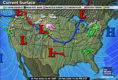
The Weather Channel map at left shows a cold front penetrating down through the central Plains today while a low pressure system forms over the Rockies.
The Weather Channel also reports that "A swath of wind-driven, accumulating snow, perhaps on the order of 4 to 8 inches with locally 10" or more, will stream eastward north of a strengthening storm center tomorrow, lining out from South Dakota across southern Minnesota into central Wisconsin. By evening, the snow should be sweeping over northern lower Michigan."
In addition, sleet and freezing rain is expected in parts of Nebraska, Iowa, and Wisconsin. Rain and thunderstorms will also prevail across the lower Midwest, while some severe thunderstorms are expected in parts of Kansas, Missouri, and Illinois.
Arctic air will then plunge southward over the northern Plains, while gusty southerly winds will bring mild air into the lower Midwest.
Major Storms for February and March?
Saturn, Uranus and Winter 2008-09
Introduction to the Weather Alternative
How Long-Range Forecasts Are Made
The Two Laws that Make Civilization Possible:
Do all you have agreed to do.
Do not encroach on other persons or their property. -- Richard J. Maybury
No comments:
Post a Comment