Work is under way on long-range weather forecasts for Hurricane Season 2006. This will take awhile before they are posted.
Another project to be posted is the forecast results of The Weather Alternative forecasts for October and November 2005.
Work is under way on long-range weather forecasts for Hurricane Season 2006. This will take awhile before they are posted.
Another project to be posted is the forecast results of The Weather Alternative forecasts for October and November 2005.

Click here for November Forecasts.
Graphics courtesy of Accuweather.com
Conventional forecasters are saying that the blizzard affecting the Northern Plains with over a foot of snow and sustained winds of 40 mph and gusts up to 60 mph will go down is history as the Great Plains Blizzard of 2005.
The Weather Alternative posted the following forecast on September 9, 2005:
November 27-29, 2005:
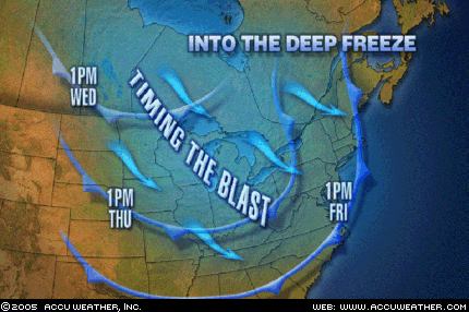
Forecast: Increasing wind speeds and falling temperatures will be the story from the western Great Lakes, across the Mississippi Valley, and eastward as cold Canadian air pushes southward. This weather pattern will extend across the eastern Great Lakes and into the Mid-Atlantic area etc...
Click here for November Forecasts
Weather Graphic courtesy of Accuweather.
This Weather Alternative forecast was posted on September 9th, over 2 months ago.
November 27-29, 2005:
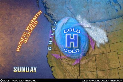
Forecast: A cool high pressure area will enter the West Coast. This drier air mass may ignite some storms and windy conditions in its attempt to establish itself over the region.
The Weather Channel reports that "strong, gusty winds are expected to gallop over the Southwest—especially the higher elevations—and the southern Great Basin. Strong Santa Ana winds are likely tonight and early tomorrow in Southern California."
The National Weather Service has issued a frost adivsory for parts of California:
NATIONAL WEATHER SERVICE
HANFORD CA
636 PM PST SAT NOV 26 2005
...FROST ADVISORY ISSUED FOR THE CENTRAL AND SOUTHERN
SAN JOAQUIN VALLEY FOR TONIGHT....A COLD AND DRY AIRMASS...ALONG WITH LIGHT WINDS AND CLEARSKIES...OVER THE CENTRAL AND SOUTHERN SAN JOAQUIN VALLEY WILL ALLOW TEMPERATURES TO DROP TO NEAR FREEZING BY EARLY
SUNDAY MORNING.
Click here for November Forecasts.
Graphics courtesy of Accuweather.com
Here's another Weather Alternative forecast that was posted back on September 9, 2005:
November 21-24, 2005:
Forecast: This promises to be a very active period for the Plains. The necessary ingredients to produce blizzard-like conditions seem to be present over the Northern Tier States.
The National Weather Service has issued Winter Storm warnings for the Great Lakes area.
URGENT - WINTER WEATHER MESSAGE
NATIONAL WEATHER SERVICE
MARQUETTE MI 519 PM EST TUE NOV 22 2005
...DANGEROUS WINTER STORM FOR THE THANKSGIVING HOLIDAY...
.LOW PRESSURE MOVING INTO THE UPPER GREAT LAKES WEDNESDAY WILL INTENSIFY AS IT MOVES SOUTHEAST INTO THE CENTRAL GREAT LAKES WEDNESDAY NIGHT. BEHIND THE LOW PRESSURE...A BLAST OF ARCTIC AIR WILL SURGE ACROSS LAKE SUPERIOR...GENERATING HEAVY LAKE EFFECT SNOWSHOWERS ACROSS UPPER MICHIGAN WEDNESDAY NIGHT THROUGH THURSDAYNIGHT. VERY STRONG NORTHERLY WINDS WILL CREATE BLIZZARD CONDITIONS NEAR LAKE SUPERIOR WEDNESDAY NIGHT THROUGH THE THANKSGIVINGHOLIDAY.
Click here for November Forecasts
Graphics courtesy of Accuweather.com
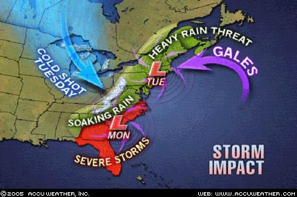
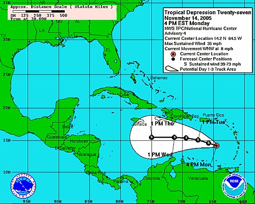
As shown above, conventional forecasters are predicting a major East Coast storm Monday and Tuesday, November 21-22, 2005.
Accuweather states "Adverse weather with the big East Coast storm will begin in the Southeast late Sunday and early Monday before spreading quickly through the Eastern Seaboard to New York and New England Monday through early Tuesday... Much of Florida and Georgia through the coastal plain of the Carolinas and southeastern Virginia will have a threat of severe local thunderstorms, including hail, high winds and even isolated tornadoes... Another factor will be that of high winds, especially coastal winds, as the storm spins up dramatically late Monday through Tuesday. New England will bear the brunt of coastal winds along with tide and wave action, but there will be strong winds well inland at this time too. As if these were not enough, there will be a wintry side to the storm, too. Cold air will pour into the Midwest Monday night and Tuesday.
(Bold print added by The Weather Alternative)
On September 9th of this year, The Weather Alternative posted forecasts for November 2005. The East Coast storm and the cold air entering the Midwest were mentioned in these forecasts although the timing seems to be a day or so off.
For example, the cold air to pour into the Midwest on the 21st and 22nd was mentioned in the November 19-20 forecast:
"Another bout of blustery weather and lower temperatures is shown for the Mississippi Valley and Eastern U.S. "
The East Coast storm scheduled for Monday and Tuesday November 21-22 was specified in The Weather Alternative forecast for November 23-24:
"The clash between high and low pressure systems will focus on the coastal areas of Virginia and North Carolina. High winds or severe storms are likely to hit this area. This may be part of a larger weather pattern that affects the Mid-Atlantic area."
Click here for November Forecasts.
Here are some updates on The Weather Alternative's November Forecasts. These were prepared between August 21, 2005 and September 6, 2005.
November 12-15, 2005:
Forecast: It seems that a tropical weather system, be it a tropical wave, storm etc., or other severe weather pattern will affect Hispañola.
As can be seen from the above map, Tropical Depression 27 (soon to be upgraded to Tropical Storm Gamma) is forecast to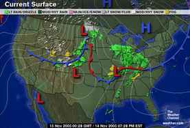 pass close to Hispañola over the next few days.
Another Weather Alternative forecast that's shaping up is the following:
November 14-17, 2005:
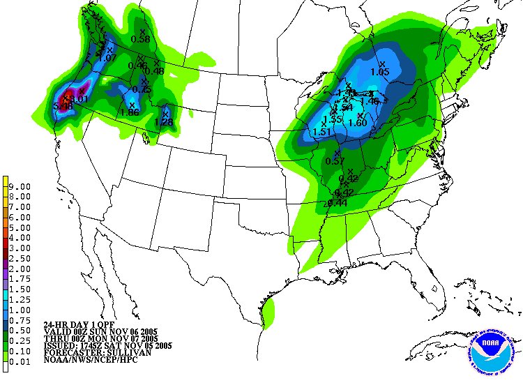
Forecast: The incursion of colder air over the eastern half of the country and consequent tumbling temperatures will necessitate frost and freeze advisories over the region. The 16th and 17th appear to be high points when cold air and windy conditions will manifest over the Mississippi Valley area.
The Weather Channel reports the following:
A strong cold front will smash into the South tomorrow, and with it, some very dangerous weather. While scattered showers and storms will speckle much of the South, nasty thunderstorms with the potential for damaging winds and violent tornadoes will sweep eastward from the eastern parts of Oklahoma and Texas across the Mississippi Valley during the daylight hours and on eastward during the evening. At highest risk for potentially deadly storms are eastern Arkansas, western Tennessee, northern Mississippi and northwest Alabama. Behind the front, gusty winds will hurl colder air southward toward the Texas Gulf Coast and eastward into the lower Mississippi Valley.
Click here for November Forecasts
The Weather Alternative forecasts for November 2005 were prepared between August 21, 2005 and September 6, 2005.
Here's an update on two forecasts for November 5-7, 2005.
Forecast: Another round of storms batters the West Coast States. Moist, warm air finds its way over the region producing "caffeinated" storms over the Intermountain West.
Today the Weather Channel reported "Another Pacific storm will take aim on the Pacific Northwest today resulting in increasing winds, rain and snow. This system is the latest, in a series of storms, to batter the Pacific Northwest and this trend will continue next week. A flood watch in effect for today and through much of Sunday for northwestern Oregon including the Willamette Valley."
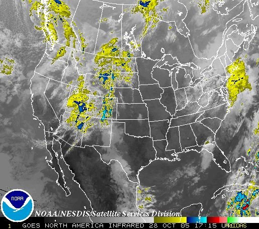
Forecast: As warm, moist air is funneled northward over the Plains, colder, drier air rushes southward over the Mississippi Valley. The inevitable result is that storms will erupt over both these areas as the colder air collides with this southerly invasion. Watch, in particular, for strong storms over the Arrowhead of Minnesota. Gusty winds usually accompany this pattern.
Today Accuweather related the following: "Cold air blasting in from the northern Plains is colliding with warm, moist air from the South, creating an explosive, fast-moving band of thunderstorms that will pummel the Midwest and parts of the Great Lakes today. The region will experience a line of strong storms with high winds, locally heavy rainfall, and possibility of hail. Scattered power outages are possible due to the high winds and damage caused by the storms."
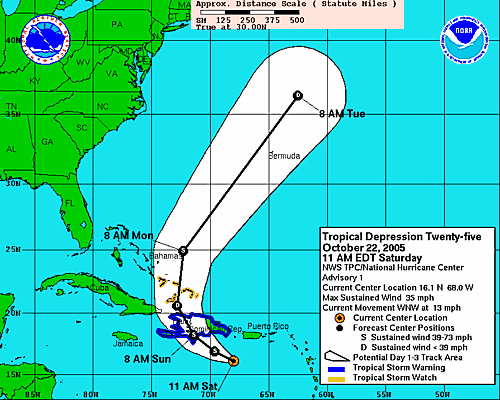

MSNBC reported today that "Hurricane Wilma triggered mudslides that killed up to 10 people in Haiti as the season’s record-tying 21st storm strengthened rapidly on Tuesday and headed for the Gulf of Mexico on a path toward storm-weary Florida."
Conventional forecasters foresee Wilma hitting southern or central Florida by this weekend. This Saturday, the 22nd, shows important planetary alignements between the Sun and Jupiter, and Mercury and Mars. The recent Lunar Eclipse of October 17th focuses some of these energies over the Florida Panhandle. This may be an indication where Wilma will make landfall.


