 It's time to look at the results of the September 11-18, 2009 forecast, which was posted on September 1st.
...the Gulf Coast area, roughly from New Orleans to the Florida Peninsula, will be under some very severe weather patterns. This was based on the Saturn-Uranus opposition, among other things. The forecast also stated there may be some tropical storm or hurricane development in the Gulf of Mexico. The strike zone could be from New Orleans to the Florida Panhandle.
During the beginning of the forecast period, conventional meteorologists thought that a low pressure system in the Gulf might develop into some sort of tropical system. Although this never happened lots of moisture from the Gulf has been pumped up over the very forecast area mentioned, and as of today is still being pulled up over the area--thus fulfilling the severe weather prediction for the area from New Orleans to the Florida Peninsula.
A whopping 5.92 inches of rain has soaked Pensacola, Florida, and flash flooding problems have followed torrential rain from Arkansas and Louisiana through Georgia. Multiple high water rescues were preformed in Birmingham, Alabama just to mention some of the recent troubles due to the excessive rain.
The next part of the forecast stated 
On the 11th, a coastal storm pounded the mid-Atlantic with flooding rain, gusty winds, rough surf, beach erosion and isolated tornadoes. The storm continued on the 12th and because it had tropical characteristics, Accuweather referred to it as The Unnamed Storm. The storm also affected the Northeast and southern New England with flooding rain. This was the main storm during the forecast period although I envisioned more intense storms to take place around the 15th through the 18th.

On the 13th, the aforementioned Unnamed Storm passed by Nova Scotia. The Canadian Weather Service stated A low pressure system south of Nova Scotia will intensify as it tracks northeastward today and tonight. The low is forecast to track across Newfoundland Monday afternoon. Ahead of the low, southeast winds gusting to 100 km/hour...

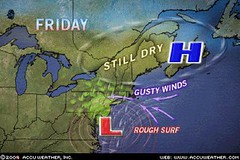
The 18th (see map at left) brought a low pressure system and front to the area triggering showers.
September 11-18, 2009 Forecast for Eastern U.S. and Nova Scotia
Solar Eclipse Action for August and September 2009
Solar Eclipse Action October and November 2009
Introduction to the Weather Alternative
How Long-Range Forecasts Are Made
Good Science
Good science--good physics, good biology, good chemistry and good economics--depend upon the ability to predict. In other words, if a physicist correctly predicts the moment at which a projectile will strike its target, or a biologist correctly predicts the effect a change in temperature will have on a population of insects, then we can say that these scientists are using good science. On the other hand, if the predictions are wrong, then the science is flawed. --Richard Maybury
No comments:
Post a Comment