Thursday, November 30, 2006

Windy Weather Coming!


Click here for the Introduction to The Weather Alternative

Our sun and its celestial entourage constitute an amazing piece of machinery whose order and unfailing precision certainly make one think of intelligent design over random stellar evolution.

As far back as Genesis chapter 1, the sun, moon, and stars were given the role of a celestial timepiece to be for signs, seasons, days, and years. In other words, they have a practical function other than inspiring awe in humankind. The practical purpose of the sun and moon are well known. God obviously intended the sun to provide us with the heat, light, and food necessary to sustain life on earth in addition to providing those beautiful sunsets. Beside inspiring lovers to stroll beneath its silvery beams, the moon, of course, controls the ocean’s tides as well as regulating the rhythms of certain life forms.

Now it would stand to reason that the other heavenly bodies of our solar system have some practical function as well. Many brilliant minds throughout history have equated terrestrial weather patterns with celestial phenomena. Johannes Kepler, the 17th century astronomer and discoverer of the planetary laws of motion, first achieved fame due to his long-range weather forecasts based on planetary positions. Since planetary phenomena can be calculated years in advance, their effect on weather patterns can be known long before conventional meteorological forecasts can detect them if we follow Kepler’s method.

For centuries the planet Mercury has been equated with wind direction and velocity. When aligned with Mars, storms and whipping winds ensue. One of the last alignments between Mercury and Mars occurred on September 15, 2006. Based on this configuration, I prepared a forecast in December 2005 that was published in the July 2006 edition of Dell Horoscope calling for windy and stormy conditions over the Mississippi Valley. The result was strong gusty winds over the area. (Click here to see forecast results)

The next alignment between Mercury and Mars takes place on December 9, 2006. The atmosphere should once again respond with gusty winds and storms roughly from the 9th to the 11th. This time a few areas of the country should feel this influence. Windy conditions should push ashore over the West Coast and advance toward the Rockies. The Plains area should respond with gusty winds as should the Mid-Atlantic and Northeast.

It never ceases to amaze me how the Creator included in his handiwork a built-in and environmentally safe weather forecast system for our benefit. Good thinking!
Tuesday, November 28, 2006

Severe Weather for the Plains


Click here for the Introduction to The Weather Alternative

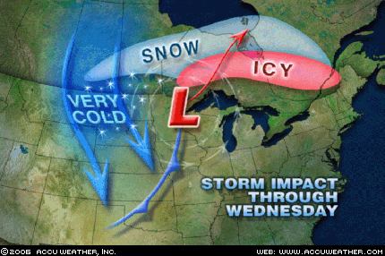
In fulfillment of my long-range weather forecast that appeared in the July 2006 edition of Dell Horoscope (see forecast), the Plains are rockin' and reelin' as a powerful cold front slides eastward through Wisconsin, Lake Michigan, Illinois, and Missouri.

The forecast called for severe weather over Missouri and Iowa. Today the Weather Channel confirms this, "Cloudbursts and thunderstorms, some severe (at least in Illinois and Missouri), will accompany the front."


The forecast also called for more weather woes for the West Coast. Accuweather reported the following yesterday:

Arctic Blast Follows the Snow and Rain
Arctic air that had been bottled up across Alaska and Canada's Yukon Territory pressed into Washington and Oregon Sunday and will continue to grip the Northwest through Wednesday before following the storm system to the east.

Thursday, November 23, 2006

November 28-30, 2006

Click here for the Introduction to The Weather Alternative

Here's a forecast of mine that was published in the July 2006 edition of Dell Horoscope:

Nov. 28-30, 2006:

This period boasts a double whammy as Mercury squares Neptune, and Mars squares Saturn. Atmospheric disturbances will develop over the Plains as warm, moist air collides with its cold, dry counterpart. An outbreak of deadly weather is indicated over Missouri and Iowa. More weather woes are also in store for the West Coast States. Additional tropical moisture is pumped into the area and should ignite storms producing flash floods.

Friday, October 27, 2006

Drenching Rains in India


Click here for the Introduction to The Weather Alternative

Click here for October 2006 Hurricane and Severe Weather Outlook

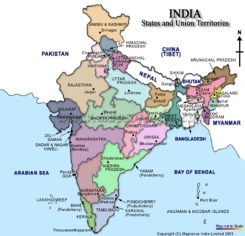
Drenching rains along India's east coast confirm The Weather Alternative's long-range forecast for October 22-25. This forecast was prepared in January 2006 and published in the July 2006 edition of Dell Horoscope. The forecast was a follows:

Oct. 22-25:
The potential for major tropical activity is also shown for the eastern coast of India.

Yesterday Accuweather reported:

International Weather News Center World Weather Summary
Posted: 26-OCT-2006 11:24am EDT


Downpours drenched the eastern shores of southern India Wednesday to Thursday. Among observation sites, Chennai (Madras) was wettest with 5.63 inches of rain within 24 hours ending Thursday morning, local time; this is more than half of the average rainfall for all of October.

Thursday, October 26, 2006

Colorado Blizzard

Click here for October 2006 Hurricane and Severe Weather Outlook

Click here for the Introduction to The Weather Alternative

The Weather Alternative Forecast for Oct 25-27 posted at the end of September is certainly shaping up.


Oct 25-27:
A vigorous low pressure system will trek across the Rockies generating strong storms.


Here's what Accuweather has to say:

Snowstorm Impact
Updated: Wednesday, October 25, 2006 3:01 PM
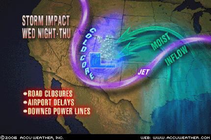
This will be remembered as a big storm. The heaviest snow will fall in the Colorado Rockies and along the Front Range. Snowfall totals will exceed a foot in the south-central part of the state. In Denver, AccuWeather.com expects up to 8 inches. Storm development will be explosive later Wednesday night as air masses clash. The intensifying swirl of air will cause winds to reach 40 miles or more resulting in blowing snow and blizzard conditions. The only thing missing will be extremely low temperatures, which is a trait of a true blizzard. The storm will close roads, cause airport delays and bring down power lines. The snow from this storm will not expand across the Great Plains due to a lack of cold air. There it will just rain.

Monday, October 23, 2006

Coast to Coast

Click here for October 2006 Hurricane and Severe Weather Outlook

Click here for the Introduction to The Weather Alternative

A number of forecasts were posted at the end of September for October 22-25. Here's a run down on their accuracy.

Forecasts Posted at the end of September

Oct. 22-25:

A new wave of inclement weather reaches the West Coast States. The period climaxes with the potential for tempestuous, widespread storms and heavy downfall.

The Plains should respond with an outbreak of severe weather, which may include possible tropical storm implications along the southwest coast of Texas.

The potential for major tropical activity is also shown for the eastern coast of India.

The eastern U.S. should be dealing with its own weather anomalies as temperatures skyrocket. The atmosphere may try and equalize the situation by unleashing strong storms over the Southeast and Mid-Atlantic regions. A tropical system cannot be ruled out.

Another Hurricane Hot Spot may develop off the eastern coast of Nicaragua threatening Central America, while the island of Jamaica is in for severe weather as well.


West Coast

The Weather Channel today reports " Two separate systems will hurl showers into the West tomorrow; one into the Pacific Northwest, the other into the Southwest." That looks good for my forecast above.

Plains


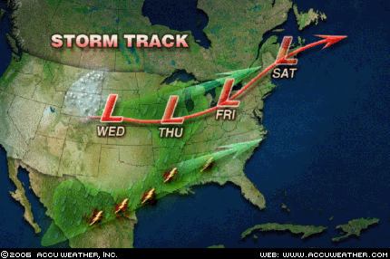
Accuweather is forecasting a storm for the Plains starting on Wed. Oct 24th, which would fall within dates for my forecast.


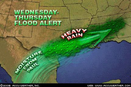
The next Accuweather graphic is interesting since my forecast calls for "possible tropical storm implications along the southwest coast of Texas."


Accuweather says "Moisture from Hurricane Paul will come up into Mexico, then turn eastward into Texas this week. This, combined with a storm taking shape across the central states, could mean another heavy rain event for southeastern Texas and Louisiana..."


India

Nothing reported as of yet.

Eastern U.S.

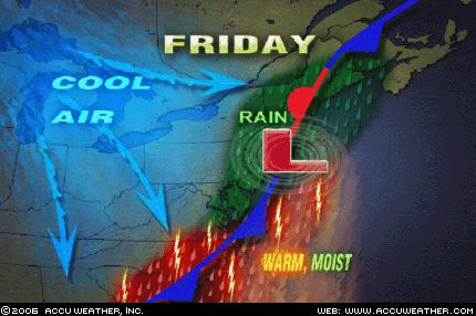
Yesterday Accuweather reported that "Rain is moving eastward today across the Great Lakes as a storm system over Lower Michigan this morning heads northeastward into southern Ontario. This system will spread rain eastward by this evening into western New England, upstate New York, western Pennsylvania and West Virginia."

Central America

No tropical trouble has been reported over Central America.

Today the National Weather Service reported "WIDELY SCATTERED TSTMS HAVE POPPED UP ALONG COASTAL AREAS FROM GUATEMALA TO NRN COSTA RICA..."

Wednesday, October 18, 2006

New Western Storm and Eastern Rain

Click here for October 2006 Hurricane and Severe Weather Outlook

Click here for the Introduction to The Weather Alternative


The Weather Alternative long-range forecast for October 19-21 called for Showers and storms hit the Northeast down through Virginia, the coastal areas of Florida, Georgia, and South Carolina with falling temperatures and a new round of storms for the West Coast.

Here's the latest from Accuweather:


By Friday (20th), the cold front will reach the East Coast as chilly air continues to spread in from the west. The front and an area of low pressure along it will bring rain from New England southward along the mid-Atlantic coast, while thunderstorms will rumble across the eastern Carolinas.


Wet weather will break out across the Northwest over the next couple of days as a storm arrives from the Pacific. A moist and mild flow into Washington and Oregon will mean snow levels in the Cascades will stay rather high; mainly above pass level.

Sunday, October 15, 2006

Rockies Storm and Texas Trouble

Click here for October 2006 Hurricane and Severe Weather Outlook

Click here for the Introduction to The Weather Alternative

Forecasters are just now becoming aware of the storm potential developing over the Rockies and Plains. The Weather Alternative forecast (see below), crafted last December and January and published in the July issue of Dell Horoscope, pinpointed the developing weather systems months ago.

Oct 15-18, 2006
Abundant moisture is also drawn up over the Plains creating severe weather potential along the Front Range of the Rockies.

Accuweather reports the following:


Another system - an upper-level low, will move across Arizona today spreading plenty of moisture northeastward into New Mexico and the western half of Texas. This will lead to thunderstorms as well across this area. Given
the proximity of the upper-level low and its associated cold pool of air aloft, stronger thunderstorms in this area will have the risk for hail in them.


The Next Cold Shot
One nice thing about fall is it is a season in
transition. If you don't like the weather at one point, give it time, and it will change. That will happen the middle of this week across the northern Rockies and much of the Midwest as the next shot of cold air is released. This air mass will not be quite as cold as its predecessor, but will still be cold enough to drop temperatures back downwards significantly and also set the stage for another winter storm from Montana to the Colorado Rockies and into the Dakotas and western Nebraska, come Tuesday (17th) and Wednesday (18th).

Friday, October 13, 2006

Coming Changes for East and West Coasts

Click here for October 2006 Hurricane and Severe Weather Outlook

Click here for the Introduction to The Weather Alternative

The weather patterns contained in forecasts prepared back in December 2005 and posted here in September 2006 are beginning to become evident to conventional meteorologist. These call for good sized storms over the Mid-Atlantic region and a moisture-laden air mass over California. (See forecast below)
The wet weather in California starting today is a bit earlier than I predicted. The approaching storms over the Mid-Atlantic will arrive as forecast.

Forecast

Oct. 15-18:
The general weather pattern over California begins to change now as a warmer more moisture-laden air mass enters the region. This may result in tropical moisture being funneled into the area setting off heavy showers. Fog may also be a concern now.
The Mid-Atlantic States will have to deal with what promises to be some good-sized storms of their own.

From Accuweather:
A storm system sitting just off the Southern California coastline will slide inland today, bringing showers and thunderstorms that have been dry for much of the summer. Today, locations such as Los Angeles and San Diego will be rather cloudy with showers and thunderstorms in the area. While heavy rain is unlikely, the recent forest fires have left mountainsides exposed, and it will not take too much rain before mudslides will form. This storm system will continue to track inland, bringing rain into the Desert Southwest over the weekend.

While the Eastern Seaboard is dealing with chilly temperatures this Friday the 13th, wet weather is on the horizon. After mainly dry conditions persist through the weekend, a storm system currently moving into Southern California looks to overspread the mid-Atlantic states and Southeast with rain and thunderstorms next Tuesday(17th). Before arriving over these areas, moisture interacting with the system will allow the wet weather to first pour down on the South Central states on Sunday, then over the southern Mississippi and Tennessee valleys on Monday. With the rich moisture streaming overhead, be advised that some of the rain could fall heavily each of these days.

Monday, October 09, 2006

Stormy West and Rockies

Click here for October 2006 Hurricane and Severe Weather Outlook

Click here for the Introduction to The Weather Alternative

Scroll down to see more long-range forecast results

Here's another long-range forecast issued by The Weather Alternative at the end of September that's shaping up:

Oct 8-10:
A storm system moves in over the West Coast States and pushes toward the Rockies.


The Weather Channel reports today that:

Two disturbances will bring wet weather to a large part of the West on Monday. An upper low over western Arizona will pump moisture into the Four Corners region and across the Rocky Mountains.
As a result, look for showers and thunderstorms across Arizona, New Mexico, Utah, and Colorado.
Flood watches are in effect for portions of Utah and Colorado as some of the rain could be locally heavy.

Farther north, another disturbance will trigger snow across the Northern Rockies. Snow advisories and winter storm warnings are in effect for parts of Montana and Wyoming, and some mountain locations could see a foot of snow.

Weather graphic courtesy of Accuweather

Saturday, October 07, 2006

Coming Cold Wave

Click here for October 2006 Hurricane and Severe Weather Outlook

Click here for the Introduction to The Weather Alternative

Conventional meteorologists over the last few days have been warning us of a very powerful cold front that will push southward over the Plains and move toward the east. Here's the latest from Accuweather:
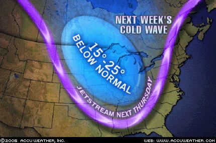
...a blast of cold air...will reach the Plains Wednesday (11th) of next week. A sharp cold front from northern Canada will bring temperatures 15 to 25 degrees below normal, and combined with a strong wind, a drastic change will be on the horizon. Showers and thunderstorms ahead of this cold front will pass through the Plains and into the east. Some locations will receive their first snow of the season behind this cold front as rain will change to snow across the northern Plains, northern Great Lakes, as well as the northern Rockies.
This cold blast will reach southward into the southern Plains and push eastward toward the Atlantic coastline.


This will be a direct fulfillment of The Weather Alternative's October 10-12, 2006 forecast posted at the end of September, which read:

Storms should rev up over the Plains and West Coast. After the 12th, falling temperatures and windy conditions are in store for the eastern U.S.

Wednesday, October 04, 2006

Coastal Storm Approaches

Click here for October 2006 Hurricane and Severe Weather Outlook

Click here for the Introduction to The Weather Alternative

The Weather Alternative forecast for October 5-7, 2006 was prepared in December 2005 and stated "Storms hit from coastal North Carolina and Virginia through the Northeast."

Today Accuweather confirms this long-range forecast.

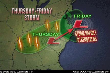
Following summer's brief return, a coastal storm will batter the central Atlantic states as the workweek draws to a close. After causing showers and thunderstorms to rumble across the Northeast, a cold front will drop into the Tennessee Valley on Thursday (5th). Instead of making a quick passage through the region, an area of low pressure will slow down the front's southward progress. To complicate matters, a strong upper-level storm system will also dive into the region, allowing the low pressure to rapidly intensify as it moves off the North Carolina coast on Friday (6th). As the storm interacts with a strong area of high pressure to the north, the southeastern mid-Atlantic states and northeastern North Carolina will be pounded with heavy rain and high winds Friday into Friday night.

The Weather Alternative also issued some other forecasts for this same time period.

A tropical moisture is indicated over the Bahamas, Cuba, and Jamaica.

Jamaica's Meteorological Service issued the following statement today:

Thur..Tropical Wave passes over the island.

Fri..Surface to upper level trough over Bahamas and Cuba.

Sat..Surface to upper level trough over Bahamas and Cuba.

A storm system will advance into the Pacific Northwest and Intermountain West, pushing showers and thunderstorms into those areas.

Accuweather reported today:

The West will also be wet, thanks to a slow moving upper-level low located off the coast of Northern California. As this low works closer to the coast tonight, colder air will be drawn south into California, lowering snow levels in the northern and central Sierra Mountains to 6,000 feet.

Thursday, September 28, 2006

October 2006 Hurricane and Severe Weather Outlook

Click here for September 2006 Hurricane and Severe Weather Outlook

Click here for the Introduction to The Weather Alternative

Scroll down and check out fulfilled long-range forecast.

Oct 4-6:
A cold front over the Mississippi Valley triggers storms that push eastward.

Oct 5-7:
Storms hit from coastal North Carolina and Virginia through the Northeast.
A tropical moisture is indicated over the Bahamas, Cuba, and Jamaica.
A storm system will advance into the Pacific Northwest and Intermountain West, pushing showers and thunderstorms into those areas.

Oct 7-9:
Cold air funnels in over the Plains and pushes eastward triggering storms that eventually reach the Southeast, Mid-Atlantic, and Northeast.

Oct 8-10:
A storm system moves in over the West Coast States and pushes toward the Rockies.


Oct. 10-12:
Storms should rev up over the Plains and West Coast. After the 12th, falling temperatures and windy conditions are in store for the eastern U.S.

Oct 11-13:
Low pressure brings rain to the Bahamas, Cuba, and Jamaica. Storms will affect the coastal area of Florida, Georgia, and South Carolina.

Oct. 15-18:
The general weather pattern over California begins to change now as a warmer more moisture-laden air mass enters the region. This may result in tropical moisture being funneled into the area setting off heavy showers. Fog may also be a concern now.
Abundant moisture is also drawn up over the Plains creating severe weather potential along the Front Range of the Rockies.
The Mid-Atlantic States will have to deal with what promises to be some good-sized storms of their own.

Oct 19-21:
Showers and storms hit the Northeast down through Virginia, the coastal areas of Florida, Georgia, and South Carolina, as well as the Bahamas, Cuba, and Jamaica.


Oct. 19-21:
Storms continue to kick out into the Plains as contrasting air masses feed low pressure systems. The West Coast gets a new round of storms while temperatures drop over the eastern U.S.

Oct. 22-25:
A new wave of inclement weather reaches the West Coast States. The period climaxes with the potential for tempestuous, widespread storms and heavy downfall. The Plains should respond with an outbreak of severe weather, which may include possible tropical storm implications along the southwest coast of Texas.
The potential for major tropical activity is also shown for the eastern coast of India.
The eastern U.S. should be dealing with its own weather anomalies as temperatures skyrocket. The atmosphere may try and equalize the situation by unleashing strong storms over the Southeast and Mid-Atlantic regions. A tropical system cannot be ruled out.
Another Hurricane Hot Spot may develop off the eastern coast of Nicaragua threatening Central America, while the island of Jamaica is in for severe weather as well.

Oct 25-27:
A vigorous low pressure system will trek across the Rockies generating strong storms.


Oct 28-30:
A low pressure system off the California coast will hurl wind and rain into California and Oregon. Major changes should be underway for the Plains as well. A whirling dervish of a storm center over northern Minnesota and Wisconsin will most likely usher in windy conditions. Tropical moisture from the Gulf will help ignite hefty storms over the Ark Latex region.
A Hurricane Hotspot forms in the Eastern Pacific at 94 West Longitude and 10 North Latitude or about 400 miles south of Oaxaca, Mexico.

Wednesday, September 27, 2006

Soaking Rain for the Northeast

Click here for September 2006 Hurricane and Severe Weather Outlook

Click here for the Introduction to The Weather Alternative

The Weather Alternative's long-range forecast (prepared in December 2005) for September 26-28 is shaping up just fine. The forecast called for The potential for heavy rainfall is shown over the eastern US from the eastern Great Lakes southward to Virginia.

Here's the latest from Accuweather:

The front moving through the Great Lakes today will reach Pennsylvania and western New York by Thursday, bringing cloudy, damp weather and noticeably cooler air. The wettest weather in the coastal mid-Atlantic will come on Thursday night, and Friday looks like a washout for New England. To add insult to injury, the upper-level trough that is pushing this front along will be lifting up to the north, meaning the front will be slowing down. So, while places in the Great Lakes will just be having a quick spell of rain today, much of the Northeast will have a soaking rain for a longer period of time.

Sunday, September 24, 2006

Strong Storms for Eastern US

Click here for September 2006 Hurricane and Severe Weather Outlook

Click here for the Introduction to The Weather Alternative

The strong storms affecting the US East Coast are a direct fulfillment of the following long-range weather forecast. This forecast was prepared in December 2005, published in the July 2006 edition of Dell Magazine and posted on this blog in August 2006.

Forecast

Sept. 24-26:
A blast of cold air will assault the Mid-Atlantic and Southeast generating gusty winds and slashing temperatures.

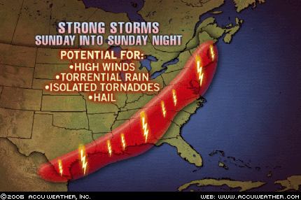
Today Accuweather published the following map and comment.


The storm system that has pounded the Midwest and Mississippi Valley with severe weather recently will sweep southward and eastward this afternoon, spreading the severe weather threat from Bangor, Maine, to Albany, Georgia, and into Brownsville, Texas. The AccuWeather.com Severe Weather Center is urging residents or visitors across these areas to keep an eye to the sky and check back to AccuWeather.com as any of these thunderstorms has the potential to produce damaging winds, heavy rain and hail. In addition, isolated tornadoes cannot be ruled out.

In addition to the above forecast, The Weather Alternative also forecast the following:

Sept. 23-25:
A tropical weather system may be brewing near the Dominican Republic and tropical moisture unloads over the Florida Panhandle.

Accuweather reports: A frontal boundary will stall across northern and central Florida through the middle of the week. Moist air will continue to spread up along the front from Monday to Wednesday, leading to widespread showers and thunderstorms. The heaviest rainfall during the period will likely be from Gainesville to Orlando, Fla.


The National Weather Service published the following about the Dominican Republic:

TROPICAL WAVE IS OVER THE LESSER ANTILLES ALONG 62W S OF 20N MOVING SLOWLY WESTWARD AT AROUND 10KT. BROADENING INVERTED-V SIGNATURE CURVATURE WITH SCATTERED SHOWERS/ISOLATED THUNDERSTORMS FROM 13N-18N BETWEEN 58W-64W. THIS WAVE WILL MOVE ACROSS THE VIRGIN ISLANDS AND PUERTO RICO LATE TODAY TROUGH MONDAY AND IS EXPECTED TO REACH DOMINICAN REPUBLIC MONDAY AFTERNOON OR EVENING...INCREASING THE CHANCE OF RAIN OVER THOSE ISLANDS.

Thursday, September 21, 2006

Large Storm for Central U.S.

Click here for September 2006 Hurricane and Severe Weather Outlook

Click here for the Introduction to The Weather Alternative

Conventional meteorologists, over the last couple of days, have realized that a potent storm system is taking shape over the Central U.S. This was forecast by The Weather Alternative back in December 2005 and posted this blog on August 24, 2006. The forecast is repeated below.

Forecast

Sept. 21-23:

The insurgence of warm, moist air over the Gulf Coast States from Texas to Florida will act as a potential storm breeder on its journey northward into the central U.S.


Graphic by Accuweather.com

Sept 21, 2006- The Weather Channel

A soaking inch-plus rain will extend from the Dakotas to the western Great Lakes. Thunderstorms will be ongoing or developing from the eastern sections of the central Plains, across the mid-Mississippi Valley, to the Ohio Valley. With a strong energetic jet stream from Kansas to Lower Michigan, warming temperatures and a plentiful return of moisture from the Gulf, severe thunderstorms with hail, damaging wind gusts and tornadoes will erupt over Iowa, Missouri and Illinois Friday. Winds will be strong and gusty over the northern Plains, Mississippi Valley, western Great Lakes and Ohio Valley.

Tuesday, September 19, 2006

September 16-17, 2006 Forecast Results

Click here for September 2006 Hurricane and Severe Weather Outlook

Click here for the Introduction to The Weather Alternative

Forecast (prepared December 2005)

Sept. 16-17:
A potential tropical disturbance may get its act together over Cuba and Florida. A low pressure system will develop over the Front Range of the Rockies.

Results

A potential tropical disturbance may get its act together over Cuba and Florida.

Sept 16, 2006- Accuweather

A lingering frontal boundary across the southern peninsula of Florida will yield a few showers and thunderstorms, but at least there are no tropical systems to worry about.

A low pressure system will develop over the Front Range of the Rockies.


Sept 16, 2006- Accuweather

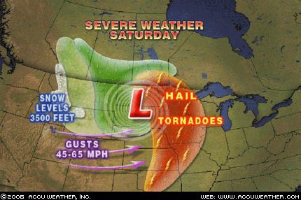
A strong storm system will dive into the northern Plains today setting the stage for a wide variety of weather… thunderstorms will become severe today with hail and even isolated tornadoes battering eastern Nebraska, western Iowa and northward into the eastern Dakotas and western Minnesota. This cold front will also lead to strong winds through the central Rockies today with gusts 45- to 65 mph. A few gusts past 70 mph could whip through canyons and gorges of the front range in Colorado and Wyoming.

Monday, September 18, 2006

September 14-16, 2006 Forecast Results

Click here for September 2006 Hurricane and Severe Weather Outlook

Click here for the Introduction to The Weather Alternative

Most of these forecasts were prepared in December 2005.

Forecast

Sept. 14-16:
Tropical activity is shown for the area in and around Puerto Rico. Meanwhile, a new cold front hits the West Coast States dropping temperatures and increasing moisture.The Mississippi Valley and eastward will be the focal point for windy and stormy conditions.

Results

Tropical activity is shown for the area in and around Puerto Rico. (66 West/18 North)

Sept 14, 2006- NWS

TROPICAL WAVE IS ALONG 64W/65W S OF 18N MOVING W 15 KT...SCATTERED MODERATE/ISOLATED STRONG CONVECTION IS FROM 14N18N BETWEEN 63W-66W.

Meanwhile, a new cold front hits the West Coast States dropping temperatures and increasing moisture.

Sept 14, 2006- The Weather Channel
West

A significant upper level disturbance will move into the Northwest today, in the wake of a cold front that passed through yesterday. With this disturbance in the area, and much cooler air moving in, scattered showers will develop during the afternoon hours.

Sept 15, 2006- The Weather Channel
West
The unusually intense storm and early season cold snap will continue to work its way across the West this weekend on its way to engulf most of the nation.

The Mississippi Valley and eastward will be the focal point for windy and stormy conditions.

Sept 15, 2006- The Weather Channel
A giant early season storm with hints of the winter to come will take control of the north-central U.S. this weekend. A strong cold front will kick off this fast-forward to late fall as it plows eastward from the Plains to the Appalachians over the next 3 days.

Severe thunderstorms with hail, damaging winds and a few tornadoes will develop Saturday from the eastern Dakotas, Minnesota and western Wisconsin to eastern Kansas and Missouri. Some severe thunderstorms will continue across Illinois and Missouri on Sunday. As the front reaches Michigan and the Ohio Valley Monday, the thunderstorms will shift eastward across the remainder of the Midwest.

While strong warm southerly winds have gusted in advance of the front, equally strong northerly and northwesterly winds will further enhance the cold over the Plains and Midwest once the front moves through.

Thursday, September 14, 2006

September 12-14 Forecast Results

Click here for September 2006 Hurricane and Severe Weather Outlook

Click here for the Introduction to The Weather Alternative

Forecast:

Most of these forecasts were prepared in December 2005.

Sept. 12-14:
Gusty winds hit the Plains, and storms affect the Mid-Atlantic, Northeast and New England. These storms over the eastern U.S. should bring abundant moisture and cause flooding problems. The culprit may be a tropical system drawn up over North Carolina or Virginia.Moisture increases over the southern California area. A front triggers showers and storms over the Rockies.Heavy rain is indicated for the island of Hispañola, which may be due to some type of tropical system.

Results

Gusty winds hit the Plains...

Sept 14, 2006- The Weather Channel

Windy conditions will develop over the central and high Plains in response to a low pressure moving toward that area.

...and storms affect the Mid-Atlantic, Northeast and New England. These storms over the eastern U.S. should bring abundant moisture and cause flooding problems. The culprit may be a tropical system drawn up over North Carolina or Virginia.

Sept 12, 2006- Accuweather

As this storm heads east, a wave of low pressure is forecast to develop along the front as it moves across Georgia late on Wednesday. That will enhance rainfall across the Carolinas and southeastern Virginia. The ground in this area remains saturated from heavy rainfall from Tropical Storm Ernesto, and there is some concern that localized flooding could occur in this area Thursday.

Sept 14, 2006- The Weather Channel

Northeast
An area of low pressure will spread rain across the Middle Atlantic into the Northeastern States today, some of which could be heavy at times.

Moisture increases over the southern California area.


Sept 14, 2006- Accuweather

Along the coastline, a thickening marine layer will prolong the low clouds, fog and drizzle along the coastline of California.


A front triggers showers and storms over the Rockies.

Sept 14, 2006- National Weather Service

THIS HAZARDOUS WEATHER OUTLOOK IS FOR WESTERN AND CENTRAL WYOMING

..DAY ONE...TODAY AND TONIGHT STRONG AND GUSTY WEST TO SOUTHWEST WINDS OF 20 TO 35 MPH ARE EXPECTED ACROSS WESTERN AND CENTRAL WYOMING THROUGH THIS EVENING AS A POWERFUL STORM SYSTEM CONTINUES TO DEVELOP OVER THE PACIFIC NORTHWEST.

AHEAD OF THIS SYSTEM THUNDERSTORMS WILL BE ON THE INCREASE THROUGH THE EVENING HOURS...ESPECIALLY ACROSS SOUTHWEST WYOMING. SOME OF THESE STORMS COULD PRODUCE WIND GUSTS TO 50 MPH...SMALL HAIL...BRIEF HEAVY RAIN AND DANGEROUS CLOUD TO GROUND LIGHTNING. A LIGHT ACCUMULATION OF SNOW IS POSSIBLE ABOVE 9000 TO 10000 FEET.

Heavy rain is indicated for the island of Hispañola, which may be due to some type of tropical system.

Sept 14, 2006- Dominican Republic Weather Service

A tropical wave is located over the Mona Passage moving westward at 26 kph. A mid to upper level low is in the troposhpere over the island.


Saturday, September 09, 2006

Stormy West Coast and Plains

Click here for September 2006 Hurricane and Severe Weather Outlook.

Click here for the Introduction to The Weather Alternative

The Weather Alternative long-range forecast for Sept 8-9, 2006 called for a stormy period for the U.S. West Coast and Plains. These forecasts were prepared during December 2005.

The Plains
Here are the latest reports from Accuweather .com:

A storm system will take shape today across the west-central Plains and then head northeastward into Illinois by Monday. This storm will tap into moist Gulf of Mexico air, allowing for rain and thunderstorms to spread on eastward with it. In the area just south of the warm front and east of the cold front, enough instability will be around along with favorable jet steam energy to allow for a few storms to be locally severe with gusty winds and hail. The best threat for a severe storm today will be in western Oklahoma and the Texas Panhandle. By tomorrow, the threat will shift into central and eastern Kansas into Missouri, and by Monday into parts of southern Illinois.

The West Coast

Sept 8, 2006- Accuweather

The wildfire danger remains at a critical level in the Northwest interior. A cold front moving into the region will bring cooler temperatures and higher humidity. However, dry thunderstorms developing ahead of the front could spark more fires, and gusty winds associated with the cold front could help to spread existing fires.

A disturbance in the upper levels of the atmosphere has been causing heavy rainfall the past couple of days over the Southwest and southern Rockies.