This forecast was developed during the first two weeks of December 2005.
Forecast
Aug. 6-7:
The coastal areas from Virginia and North Carolina through New England are in for some severe weather in the form of storms producing wind and rain.
Results
August 6, 2006-Accuweather
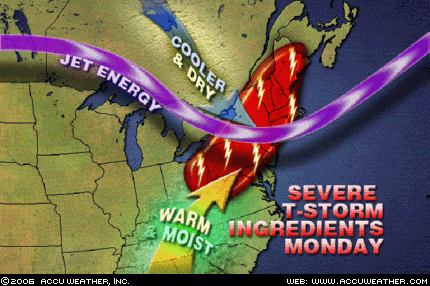
The Northeast is primed for strong to severe thunderstorms Monday...Storms will produce heavy downpours, damaging winds and large hail, with an isolated tornado possible.
August 7, 2006- The Weather Channel
Northeast
Scattered showers and thunderstorms, some severe, will gallop through the Northeast today in advance of a Canadian cold front. Gusty winds will prevail as the front approaches, and winds in some of the storms could be quite strong.
August 7, 2006- National Weather Service
BULLETIN - IMMEDIATE BROADCAST REQUESTEDSPECIAL MARINE WARNING
NATIONAL WEATHER SERVICE
WAKEFIELD VA629 AM EDT MON AUG 7 2006
THE NATIONAL WEATHER SERVICE IN WAKEFIELD HAS ISSUED A* SPECIAL MARINE WARNING FOR... CHESAPEAKE BAY FROM WINDMILL POINT TO NEW POINT COMFORT VA CHESAPEAKE BAY FROM SMITH POINT TO WINDMILL POINT VA
SPECIAL WEATHER STATEMENT
NATIONAL WEATHER SERVICE
WAKEFIELD VA851 AM EDT MON AUG 7 2006
ACCOMACK VA-INLAND WORCESTER MD-MARYLAND BEACHES MD-NORTHAMPTON VA-851 AM EDT MON AUG 7 2006
...THUNDERSTORMS MOVING THROUGH THE EASTERN SHORE...
No comments:
Post a Comment