Friday, May 27, 2016

Potential Hurricane August 24-28, 2016

A series of celestial events taking place between the 24th and 28th of August, 2016 promise the potential for severe weather that may be tropical in nature. Key astronomical charts used in long-range weather forecasting place the planetary alignments involving Mars, Saturn, Neptune, Venus, and Jupiter over hurricane-prone sectors of the US East Coast.


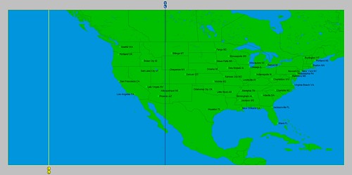
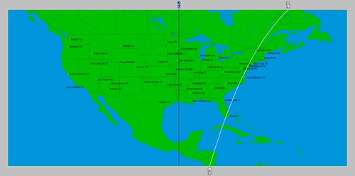
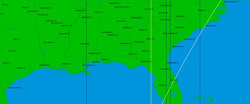
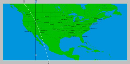
The Mars-Saturn conjunction of August 24th begins the parade of celestial harbingers. As seen from the astro-locality map below, their area of influence, represented by the yellow lines, takes in the North Carolina and Virginia coasts and into the Northeast. More importantly, the crossing of these lines with the black line representing the influence of Neptune focuses their energies about 250 miles off the coast of central Florida.
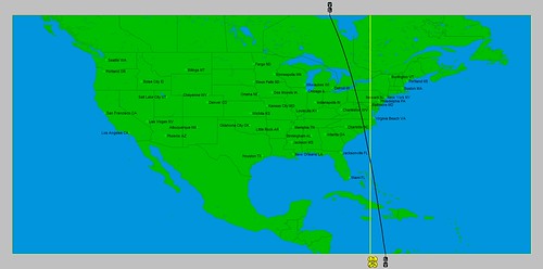


Mars Saturn Aug 2016

The alignments of Mars, Saturn, and Neptune have been observed to correspond with atmospheric turbulence, destructive, windy storms, and low pressure systems fed by tropical moisture, which can be of greater significance when occurring during hurricane season.

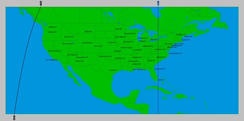
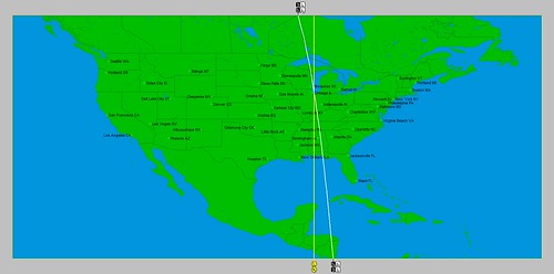
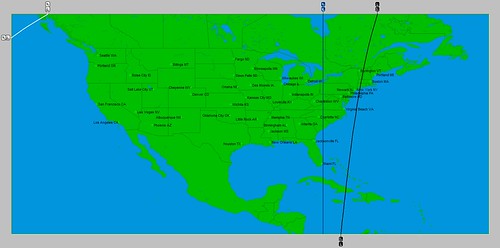
The second astro-locality map shows the positions of the Venus-Jupiter conjunction of August 27th represented by the blue lines over the New England area. These lines also converge with the Mars and Saturn white lines south of New England. Lastly, the Neptune line, shown in yellow, affects the Florida Panhandle northward through the East Central US into the central Great Lakes region.
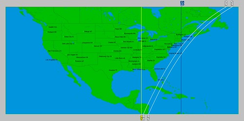

Venus Jupiter Aug 2016

August 24-28, 2016

Taken together, during the forecast period, the US East Central section is likely to experience a bout of strong storms that push through the area towards the East Coast. One likely scenario shows the development of a tropical system off the coast of Florida which would then travel in parallel to the coast with a strong chance of affecting the New England area. A second scenario calls for tropical moisture, that doesn't develop into an organized tropical system, to be pulled northward over the Carolinas fueling storms that affect the Mid-Atlantic, Northeast, and New England areas.


Links to Other Long-range Weather Forecasts and Forecast Results


June 13-21, 2016 Long-range Weather Forecast 
June 1-5, 2016 Long-range Weather Forecast
Hurricane Dolores Fulfills Long-range Weather Forecast
Hurricane Season 2015 Long-range Weather Predictions
Tropical Cyclone Hadi
Hurricane Erick Fulfills Long-range Forecast
Tropical Storm Andrea Fulfills Long-range Forecast!
Timing the Relief for Drought-Stricken U.S. Plains
Testing Astrometeorology Part 2
Hurricane Sandy Fulfills Long-range Weather Prediction!
Testing Astrometeorology Part 1
Hurricane Season 2011 Forecast Results
Hurricane Risk-Management
New Weather Alternative Website
Fulfilled Long-range Forecasts for Hurricane Season 2010
Introduction to the Weather Alternative
A Blast From the Past

Leonard Cohen performs his classic song with a mind-blowing assist from saxophone giant Sonny Rollins.

Sunday, May 22, 2016

June 13-21, 2016 Long-range Weather Forecast

June 2016 will provide an opportunity to confirm the pluvial nature the planet Neptune is said to exercise on weather patterns. The geographical areas that fall under the influence of Neptune in key weather charts have been observed to experience southerly, moist, air flows that increase humidity resulting in intense downpours and flooding potential.

On the 13th of June, Neptune will make its retrograde station which is a key event in triggering the above mentioned atmospheric conditions. The 17th of June features the square aspect between Saturn and Neptune which also excites deep low pressure systems that result in higher than average rainfall. Then, on the 20th of June, Mercury will oppose Saturn and square Neptune activating their influence once again. In a minute we'll look at the areas that will be affected this year. But first, let's see what happened to atmospheric conditions the last time Neptune made it retrograde station and the last time Saturn squared Neptune.

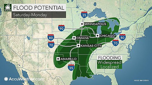
On June 12, 2015, Neptune made its retrograde station. In the key seasonal chart, Neptune's influence affected the eastern Plains states roughly from Louisiana northward through Minnesota. As can be seen from the Accuweather map below this is the exact area that experienced widespread localized flooding from June 13-15, 2016. This was in part due the Tropical Storm Bill that hit Texas at that time and continued northward.

13 Texas, Louisiana

The last Saturn-Neptune square occurred on November 26, 2015. Neptune's influence affected the Mississippi Valley and eastward while Saturn's influence affected the Eastern Seaboard. The National Weather Service forecast for Nov 27-29, 2015 warned, "Flash flooding possible across portions of the southern plains and mid-Mississippi valley." Their forecast for Nov 29th stated, "Scattered to numerous rain showers is forecast northeast Texas to central Virginia where 3-day totals of 1 to 5 inches will be possible. Locally higher amounts may be observed in eastern Tennessee and western North Carolina."

Forecast

This year Neptune will occupy the 82nd line of west longitude running from Florida through Ohio. This area will likely be subjected to heavy rainfall that produces widespread flooding as we've seen in last year's example. Since we're in hurricane season, we can rule out a tropical system at this time. The weather pattern will then travel eastward and affect the US East Coast.

In other key charts, the US West Coast is also affected by Neptune and Saturn. June is not as rainy as other months out west but we may see some anomalous weather pattern develop over the Pacific Northwest especially around the end of the forecast period (19th - 21st). This may be something like a dramatic increase in temperatures and humidity or an anomalous low pressure system.


Links to Other Long-range Weather Forecasts and Forecast Results


June 1-5, 2016 Long-range Weather Forecast
Hurricane Dolores Fulfills Long-range Weather Forecast
Hurricane Season 2015 Long-range Weather Predictions
Tropical Cyclone Hadi
Hurricane Erick Fulfills Long-range Forecast
Tropical Storm Andrea Fulfills Long-range Forecast!
Timing the Relief for Drought-Stricken U.S. Plains
Testing Astrometeorology Part 2
Hurricane Sandy Fulfills Long-range Weather Prediction!
Testing Astrometeorology Part 1
Hurricane Season 2011 Forecast Results
Hurricane Risk-Management
New Weather Alternative Website
Fulfilled Long-range Forecasts for Hurricane Season 2010
Introduction to the Weather Alternative


Saturday, May 21, 2016

May 2016 Forecast Results

On April 2nd of this year, I published some long-range weather forecasts for May 2016. These forecasts discussed the likely weather patterns that would result from the Sun-Mercury conjunction of May 9th, and the Mercury-Venus conjunction of May 13th. Here are the results.

May 8-13, 2016

Forecast 

The forecast stated that "we should expect a strong cold front or storm system bringing windy conditions to the area from the eastern Plains through the east central US."

Results 

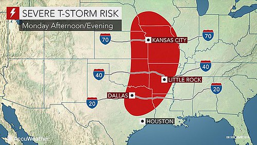
On the 8th, Accuweather headlines read "Severe storms to strike central US through early week" These storms, according to Accuweather, were to begin on Sunday the 8th into Monday the 9th. The Accuweather map below shows the area to be affected which was the area specified in the forecast.


08 Severe Storms

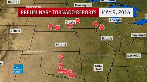
Severe storms and tornadoes continued to threaten the forecast area on the 9th and shown in the next Accuweather map.


09 Tornadoes

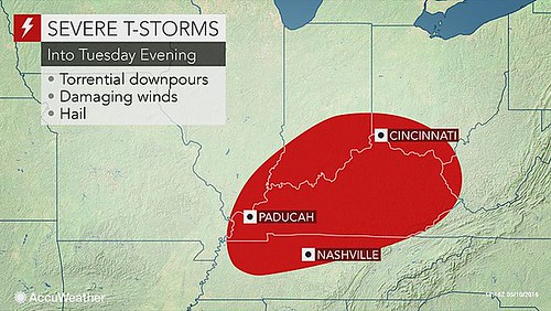
Storms began to move into the east central US as was forecast. On Tuesday the 10th, Accuweather reported that "the threat of severe thunderstorms, including tornadoes, will expand into the Ohio Valley into Tuesday night." The following Accuweather map shows the danger zone.


10 Severe Storms

The next forecast was for the western US.

May 12-15, 2016

Forecast 

We may expect an increase in temperatures and in shower and thunderstorm activity at this time over the US West.

Results

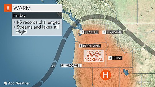
On May 11th, Accuweather meteorologists began to see the coming increase in temperatures that would affect the US West starting on Friday, May 13th. They announced "Temperatures to soar to record-challenging levels by late this week." Here's their map depicting temperatures 10 to 25 degrees above normal.


11 Northwest Tems

As far as the shower and thunderstorm activity that was also predicted in the long-range forecast, the National Weather Service reported on the 13th that "Showers and thunderstorms will increase across the Pacific Northwest tonight as a frontal boundary and upper-level disturbance move onshore. On Saturday (May 14th), showers and thunderstorms will spread into the interior Northwest and the northern Intermountain West as the system moves inland."

Links to Other Long-range Weather Forecasts and Forecast Results


June 1-5, 2016 Long-range Weather Forecast
May 2016 Long-range Weather Forecasts 
Hurricane Dolores Fulfills Long-range Weather Forecast
Hurricane Season 2015 Long-range Weather Predictions
Tropical Cyclone Hadi
Hurricane Erick Fulfills Long-range Forecast
Tropical Storm Andrea Fulfills Long-range Forecast!
Timing the Relief for Drought-Stricken U.S. Plains
Testing Astrometeorology Part 2
Hurricane Sandy Fulfills Long-range Weather Prediction!
Testing Astrometeorology Part 1
Hurricane Season 2011 Forecast Results
Hurricane Risk-Management
New Weather Alternative Website
Fulfilled Long-range Forecasts for Hurricane Season 2010
Introduction to the Weather Alternative

The Experts Explain Global Warming

Sunday, May 15, 2016

June 1-5, 2016 Long-range Weather Forecast

serveimage (1)

Planetary cycles involving Jupiter, Saturn, and Neptune come to a head in June of this year. In this post, we'll look at the period of June 1-5. The combination of Saturn and Neptune is known to bring heavier than average precipitation. Jupiter and Neptune alignments also bring low pressure and abnormally wet weather, and Jupiter-Saturn configurations signify intense downfall. The Moon, on the 3rd and 4th of June is at perigee or its closest approach to Earth. This normally intensifies weather patterns.

A number of key charts places their influence over the eastern portion of the US from the Mississippi Valley through the Mid-Atlantic and Southeast. The central and eastern Gulf of Mexico is emphasized as well.

Taken together, we can expect an outbreak of severe thunderstorms over this portion of the country. Tropical moisture from the Gulf of Mexico will most likely be imported up over the area fueling thunderstorms that potentially can trigger heavy downpours. Since the Atlantic hurricane season is now underway, it is plausible that an actual tropical system develops now.


Links to Other Long-range Weather Forecasts and Forecast Results

May 2016 Long-range Weather Forecasts 
Hurricane Dolores Fulfills Long-range Weather Forecast
Hurricane Season 2015 Long-range Weather Predictions
Tropical Cyclone Hadi
Hurricane Erick Fulfills Long-range Forecast
Tropical Storm Andrea Fulfills Long-range Forecast!
Timing the Relief for Drought-Stricken U.S. Plains
Testing Astrometeorology Part 2
Hurricane Sandy Fulfills Long-range Weather Prediction!
Testing Astrometeorology Part 1
Hurricane Season 2011 Forecast Results
Hurricane Risk-Management
New Weather Alternative Website
Fulfilled Long-range Forecasts for Hurricane Season 2010
Introduction to the Weather Alternative


Wednesday, May 11, 2016

April 22-25, 2016 Forecast Results

Here are the results of the second portion of my April 2016 long-range weather forecast that was posted on March 16th of this year. This forecast focused on the effect that the Jupiter-Uranus alignment would have on the weather over eastern US and on the West Coast states. The results of the first forecast (April 6-10) are posted here.

The next forecast period was for April 22-25. The forecast read as follows.

April 22-25

At this time Venus aligns with the Jupiter-Uranus configuration and is likely to represent another round of fronts for the West Coast states and the eastern U.S. 

Results

On April 21st, the AccuWeather headline read, "Rain to end record warmth across US West Coast by late week." 

The following AccuWeather map shows their forecast for April 21st and 22nd. Notice the low pressure area approaching California with rain, snow, and showers. Meteorologists pointed out that some of these storms could become strong and produce locally damaging winds and heavy rainfall. 

21 Rain West Coast

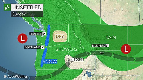
The next AccuWeather map shows their forecast for April 24th. Here we see rain, showers, and snow affecting the Pacific Northwest. They pointed out that moderate to heavy rain could reach parts of western Washington and Oregon.


23 Rainstorms

The next map from the Weather Channel is for April 21st and shows a cold front beginning to penetrate the eastern US. The National Weather Service reported a low pressure system will begin to move steadily toward the eastern US bringing a good chance of showers and thunderstorms that would end the week-long dry spell. The front continued its way across the eastern US on the 22nd.


April 21


Links to Other Long-range Weather Forecasts and Forecast Results

May 2016 Long-range Weather Forecasts 
Hurricane Dolores Fulfills Long-range Weather Forecast
Hurricane Season 2015 Long-range Weather Predictions
Tropical Cyclone Hadi
Hurricane Erick Fulfills Long-range Forecast
Tropical Storm Andrea Fulfills Long-range Forecast!
Timing the Relief for Drought-Stricken U.S. Plains
Testing Astrometeorology Part 2
Hurricane Sandy Fulfills Long-range Weather Prediction!
Testing Astrometeorology Part 1
Hurricane Season 2011 Forecast Results
Hurricane Risk-Management
New Weather Alternative Website
Fulfilled Long-range Forecasts for Hurricane Season 2010
Introduction to the Weather Alternative


Monday, April 18, 2016

April 6-10, 2016 Forecast Results

On March 16, 2016, I posted some long-range weather forecasts for April of this year. The first one was for the period between April 6-10. Here's the original forecast.

Forecast
Between these dates the Sun will participate in the Jupiter-Uranus configuration adding important energy to the mix. The potential exists for a strong front to move into the West Coast states bringing precipitation. The eastern portion of the country should see a strong cold front that ignites storm activity from the eastern Great Lakes through the Mid-Atlantic area as it moves eastward.

Results
The strong cold front forecast over the eastern portions of the country arrived as scheduled. Here's the AccuWeather map showing the arctic push between the 7th and 10th.


07 When Will It Warm

AccuWeather also reported that the cold threatened significant losses of fruit crop in the northeastern U.S. and high winds for the New England area.

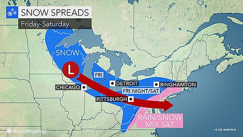
In addition, the forecast called for storm activity from the eastern Great Lakes through the Mid-Atlantic area. The next AccuWeather map shows that storm system on the 8th and 9th.

07 Snowy wintry mix

Forecast
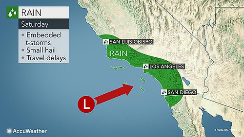
For the West Coast, the forecast mentioned a strong front bringing precipitation. On the 8th, AccuWeather meteorologists warned "Storm to soak San Diego to San Francisco this weekend." The storm was forecast to roll onto the California coast, threatening to bring flash flooding, gusty thunderstorms and travel delays. The AccuWeather map below shows the areas to be affected.

08 San Diego

The National Weather Service reported that another upper-level low would move in over the Pacific Northwest affecting Southern California and the Southwest. The low then remained nearly stationary from southern Idaho to the southern Rockies bringing numerous showers over the Desert Southwest and California.


Links to Other Long-range Weather Forecasts and Forecast Results

May 2016 Long-range Weather Forecasts 
April 2016 Long-range Weather Forecast 
Hurricane Dolores Fulfills Long-range Weather Forecast
Hurricane Season 2015 Long-range Weather Predictions
Tropical Cyclone Hadi
Hurricane Erick Fulfills Long-range Forecast
Tropical Storm Andrea Fulfills Long-range Forecast!
Timing the Relief for Drought-Stricken U.S. Plains
Testing Astrometeorology Part 2
Hurricane Sandy Fulfills Long-range Weather Prediction!
Testing Astrometeorology Part 1
Hurricane Season 2011 Forecast Results
Hurricane Risk-Management
New Weather Alternative Website
Fulfilled Long-range Forecasts for Hurricane Season 2010
Introduction to the Weather Alternative
Ex-Christian Defends the Existence of the Historical Jesus


Saturday, April 02, 2016

May 2016 Long-range Weather Forecasts

About six times a year the Sun and Mercury form a conjunction. A conjunction is when two or more celestial bodies are located along the same celestial longitude when observed from the earth. About 3 of those conjunctions occur when Mercury is in retrograde motion. This means that Mercury appears to be moving backward in the sky. In astro-meteorology, these conjunctions with a retrograde Mercury are known to excite windy, stormy conditions and cold fronts.

May 8-13, 2016

On May 9th of this year, we have one such conjunction. Our key chart for the spring season places the Sun and Mercury over the eastern Plains roughly from Texas through Missouri to the western Great Lakes. Another important chart is the solar eclipse chart of May 9, 2013. The Sun-Mercury conjunction will fall exactly on this degree. The astro-locality map below shows the area to be affected which lies over the eastern central portion of the US. Taken together the US midsection should feel the effects of the conjunction.

Sun Mercury May 2016

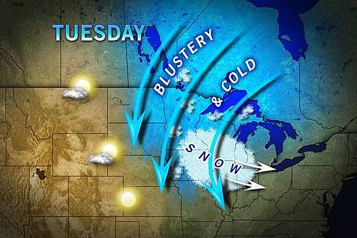
To get an idea of what actually can happen during one of these conjunctions, we can look at the weather pattern formed over the US Midwest on March 5, 2013 when a Sun-Mercury conjunction took place with a retrograde Mercury over the eastern Plains and Mississippi Valley. A winter storm affected the area with heavy snow and then high winds disrupted travel. Here's the AccuWeather map for that day.

04 Minneapolis

So we should expect a strong cold front or storm system bringing windy conditions to the area from the eastern Plains through the east central US.

May 12-15, 2016

Another interesting setup is the Mercury-Venus conjunction of May 13th. Mercury is still retrograde at this time. One of our key charts places Mercury, Venus, and the Moon over the Rocky Mountains and Great Basin areas of the US as seen in the map below.

Mercury Venus May 2016

The last time a Mercury-Venus conjunction affected the US West was on August 6, 2015. At that time the National Weather Service reported an increase in temperatures over the area and an upper level disturbance crossing California and the Intermountain West which increased showers and thunderstorms. We may expect a similar increase in temperatures and in shower and thunderstorm activity at this time.


Links to Other Long-range Weather Forecasts and Forecast Results

April 2016 Long-range Weather Forecast 
Hurricane Dolores Fulfills Long-range Weather Forecast
Hurricane Season 2015 Long-range Weather Predictions
Tropical Cyclone Hadi
Hurricane Erick Fulfills Long-range Forecast
Tropical Storm Andrea Fulfills Long-range Forecast!
Timing the Relief for Drought-Stricken U.S. Plains
Testing Astrometeorology Part 2
Hurricane Sandy Fulfills Long-range Weather Prediction!
Testing Astrometeorology Part 1
Hurricane Season 2011 Forecast Results
Hurricane Risk-Management
New Weather Alternative Website
Fulfilled Long-range Forecasts for Hurricane Season 2010
Introduction to the Weather Alternative
Saturday, March 26, 2016

March 23-26, 2016 Forecast Results

Here are the results of the last of the March forecasts posted on January 9th of this year. The basis for the long-range weather forecast was the alignment of Jupiter and Saturn. This particular segment of the forecast was for the March 23-26 period. You can read the original forecast here.

The area to be affected by the alignment centered on the 80th degree of west longitude which takes in the eastern Great Lakes and runs southward through the Carolinas. The New England area was also to be affected as can be seen from the astro-locality map below.

Jupiter Saturn

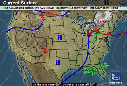
On the 24th, a low pressure system over the eastern Great Lakes and a trailing cold front aligned itself with the Saturn line running through 80 west longitude. The Weather Channel map below shows the low and front.

Mar 24

My forecast expected strong storms with potential to bring torrential downpours and gusty winds. The National Weather Service reported on the 25th that "a strong cold front moving eastward through the Ohio Valley this evening will continue to fuel heavy rainfall and thunderstorms across portions of the central/eastern Gulf Coast to the lower Great Lakes."

AccuWeather also pointed out that the Mid-Atlantic would experience blustery conditions which "will mark an end to the above-average warmth" that had prevailed over the region.

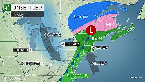
The New England area also participated in the effects of the low and front as seen in the AccuWeather map below for Friday, the 25th.

24 Late week

The National Weather Service declared that "snow and freezing rain will move into portions of northern New England with up to a quarter of an inch of ice possible."


Links to Other Long-range Weather Forecasts and Forecast Results

April 2016 Long-range Weather Forecast 
Hurricane Dolores Fulfills Long-range Weather Forecast
Hurricane Season 2015 Long-range Weather Predictions
Tropical Cyclone Hadi
Hurricane Erick Fulfills Long-range Forecast
Tropical Storm Andrea Fulfills Long-range Forecast!
Timing the Relief for Drought-Stricken U.S. Plains
Testing Astrometeorology Part 2
Hurricane Sandy Fulfills Long-range Weather Prediction!
Testing Astrometeorology Part 1
Hurricane Season 2011 Forecast Results
Hurricane Risk-Management
New Weather Alternative Website
Fulfilled Long-range Forecasts for Hurricane Season 2010
Introduction to the Weather Alternative

The Resurrection: Fact or Fiction?

Sunday, March 20, 2016

March 14-16, 2016 Forecast Results

In this post, I'll review the second of the March 2016 long-range forecasts that were published on January 9, 2016 in a post entitled March 2016 Long-range Forecasts. The second forecast period was that of March 14-16. The forecast called for storm potential over the the area from the western Great Lakes down through the Deep South with the likelihood of storms to focus over southern portions of the country.

The National Weather Service forecast for March 15-17 stated "Developing low pressure will be accompanied by significant rain across the Upper Mississippi Valley and Upper Midwest...

Accuweather headlines on the 14th stated "Election 2016: Severe storms may threaten voters in Missouri, Illinois on Tuesday" (March 15th)

Another headline of theirs read " Damaging winds, downpours to target Chicago, Indianapolis Tuesday"

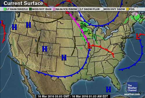
The Weather Channel map below is for the 15th.

Mar 15

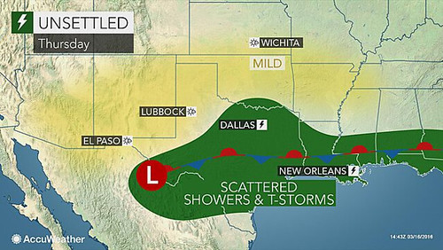
The Deep South became the focal point of a stationary front as shown in the Accuweather Map below for the 17th. Their headline warned "Late-week rain could aggravate flooding from Texas to Louisiana, Mississippi"

16 Texas Louisiana

Links to Other Long-range Weather Forecasts and Forecast Results

March 2016 Long-range Weather Forecasts
Hurricane Dolores Fulfills Long-range Weather Forecast
Hurricane Season 2015 Long-range Weather Predictions
Tropical Cyclone Hadi
Hurricane Erick Fulfills Long-range Forecast
Tropical Storm Andrea Fulfills Long-range Forecast!
Timing the Relief for Drought-Stricken U.S. Plains
Testing Astrometeorology Part 2
Hurricane Sandy Fulfills Long-range Weather Prediction!
Testing Astrometeorology Part 1
Hurricane Season 2011 Forecast Results
Hurricane Risk-Management
New Weather Alternative Website
Fulfilled Long-range Forecasts for Hurricane Season 2010
Introduction to the Weather Alternative
Mass Gains of Antarctic Ice Sheet Greater than Losses, NASA Study Reports (click to read)

nasastudymas

Wednesday, March 16, 2016

April 2016 Long-range Weather Forecast

During April of this year, Jupiter and Uranus will enter into an important alignment that will affect weather patterns over various parts of the United States. Alignments of this nature are known to result in strong cold fronts, increased precipitation, and heightened wind velocities. It may be helpful to review what weather patterns occurred during the last Jupiter-Uranus alignment in order to get a better understanding of its effects on the weather. Let's turn back the clock to October of last year.

Between the 19th and 22nd of October 2015, the planets Venus and Mars entered into a configuration that added impetus to the alignment of Jupiter and Uranus that was already underway. The locality map below shows that Uranus was positioned over the Rocky Mountains at about 110 west longitude while Jupiter was placed over the eastern Pacific at 141 west longitude.

Juipter Uranus 2015

On the 18th, the National Weather Service warned that a deep trough and upper level low would affect the western U.S. with the heaviest activity from northern Arizona to the northern Rockies where 1 to 2 inches of rain or higher could lead to flash flooding.

For the 20th, the forecast was for additional heavy rains for the Southwest and south-central Rockies.
Flash flooding was called for on the 21st for portions of the Southwest and Southern High Plains. The NWS warned of a stationary boundary over the Four Corners region and anomalous pools of moisture to increase the likelihood of heavy rain and/or intense rainfall over the region on the 22nd. Further south, Hurricane Patricia, with sustained winds of 200 mph, was being drawn toward the Uranus line at 110 west longitude.

April 2016

The next locality map shows the positions of Jupiter and Uranus during April 2016. Jupiter is represented by the blue line over the eastern U.S. at approximately 79 west longitude, while Uranus is shown by the black line off the U.S. West Coast.

Jupiter Uranus 2016

April 6-10, 2016

Between these dates the Sun will participate in the Jupiter-Uranus configuration adding important energy to the mix. The potential exists for a strong front to move into the West Coast states bringing precipitation. The eastern portion of the country should see a strong cold front that ignites storm activity from the eastern Great Lakes through the Mid-Atlantic area as it moves eastward.

April 22-25

At this time Venus aligns with the Jupiter-Uranus configuration and is likely to represent another round of fronts for the West Coast states and the eastern U.S.


Links to Other Long-range Weather Forecasts and Forecast Results

March 2016 Long-range Weather Forecasts
Hurricane Dolores Fulfills Long-range Weather Forecast
Hurricane Season 2015 Long-range Weather Predictions
Tropical Cyclone Hadi
Hurricane Erick Fulfills Long-range Forecast
Tropical Storm Andrea Fulfills Long-range Forecast!
Timing the Relief for Drought-Stricken U.S. Plains
Testing Astrometeorology Part 2
Hurricane Sandy Fulfills Long-range Weather Prediction!
Testing Astrometeorology Part 1
Hurricane Season 2011 Forecast Results
Hurricane Risk-Management
New Weather Alternative Website
Fulfilled Long-range Forecasts for Hurricane Season 2010
Introduction to the Weather Alternative

Friday, March 11, 2016

March 8-10, 2016 Forecast Results

The January 9, 2016 Weather Alternative post covered a long-range forecast for March 8-10. This forecast predicted strong storms bringing wind and rain to the area comprising the western Great Lakes southward through the Deep South due to the alignment of Jupiter and Saturn. The post discussed how the previous alignment of Jupiter and Saturn during August of 2015 had brought torrential downpours and gusty winds to the U.S. Deep South and to certain Mexican states at that time.

The following map was posted to show the general area to be affected.

March 8 2016

On March 8th, the National Weather Service warned " Showers and thunderstorms will develop along and ahead of the boundary from the Western Ohio Valley to the Lower Mississippi Valley/Southern
Plains and continue along and near the front through Thursday."

On the 9th, the NWS informed its readers with the headline "Heavy rain from parts of the Ohio Valley to the Lower Mississippi Valley and parts of the Southern Plains."

The following Weather Channel map provides a view of the low pressure area, rain, and front on the 9th.

Mar 09

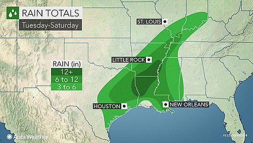
Extensive flooding plagued Texas, Louisiana, and Arkansas. The following AccuWeather map shows rain totals from 3 to 12 inches primarily over the Deep South area.

10 Texas Louisiana

More forecasts for March are posted here.


Links to Other Long-range Weather Forecasts and Forecast Results
March 2016 Long-range Weather Forecasts
Hurricane Dolores Fulfills Long-range Weather Forecast
Hurricane Season 2015 Long-range Weather Predictions
Tropical Cyclone Hadi
Hurricane Erick Fulfills Long-range Forecast
Tropical Storm Andrea Fulfills Long-range Forecast!
Timing the Relief for Drought-Stricken U.S. Plains
Testing Astrometeorology Part 2
Hurricane Sandy Fulfills Long-range Weather Prediction!
Testing Astrometeorology Part 1
Hurricane Season 2011 Forecast Results
Hurricane Risk-Management
New Weather Alternative Website
Fulfilled Long-range Forecasts for Hurricane Season 2010
Introduction to the Weather Alternative
Why the New Definition of Tolerance Is Dangerous  (click to read)


Why Some People Will Not Be Convinced

Sunday, February 14, 2016

February 7-10, 2016 Forecast Results

My long-range weather forecast for February 7-10 was posted on January 6th. The forecast warned that due to the alignment between the Sun and Mars at that time We will likely see a strong winter storm system gear up over the central U.S. and affect the northern tier states and Midwest between February 7-10. The storm during this period could push eastward and affect the Mid-Atlantic coast on up through the Northeast and New England with a weather pattern similar to that of January 2014.

The National Weather Service reported on February 6th that A deep surface low will track across the Upper Mississippi Valley on Sunday (Feb 7)...that will usher in much colder temperatures for the north-central U.S....Temperatures departures from normal highs are expected to drop from +25 today to -10 for Monday. In addition, winds will strengthen through tonight and spread  southeastward across the region on Sunday along with snow showers. 

On the 7th, the NWS also reported A second storm system is currently producing blizzard-like
conditions throughout portions of the lower Northern Plains and Minnesota. They also reported frigid temperatures from the north with winds gusting to 40 and 50 mph.

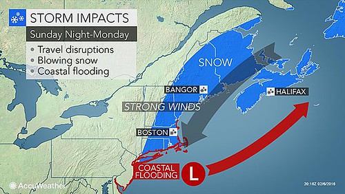
For Sunday into Monday (Feb 7-8), AccuWeather.com posted the following map showing the storm system affecting the Northeast and New England with coastal flooding and strong winds. The Accuweather headling read Waves of arctic air to freeze the eastern US into Valentine's Day

06 Northeast 1

The second part of the forecast pertained to the western U.S. where I envisioned a round of winter storms punching their way into the West Coast. On the 6th, the National Weather Service reported strong and gusty winds for the 6th and 7th over portions of southern California due to building high pressure over the Great Basin area.

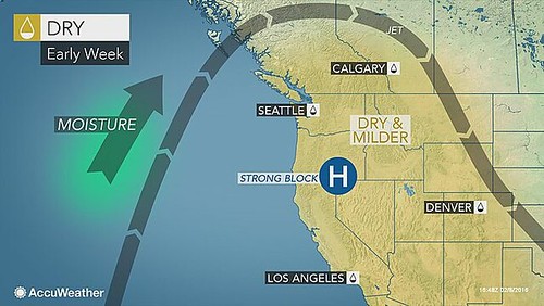
The high pressure area took hold and increased temperatures for the region as shown in the AccuWeather map below. Except for the aforementioned windy conditions, this is pretty much the opposite of what I expected. Although the effect of the planet Mars on the weather has traditionally been that of increasing temperatures, I foresaw this particular Sun-Mars alignment as being more of a storm breeder than anything else.

08 West

Links to Other Long-range Weather Forecasts and Forecast Results
March 2016 Long-range Weather Forecasts
Hurricane Dolores Fulfills Long-range Weather Forecast
Hurricane Season 2015 Long-range Weather Predictions
Tropical Cyclone Hadi
Hurricane Erick Fulfills Long-range Forecast
Tropical Storm Andrea Fulfills Long-range Forecast!
Timing the Relief for Drought-Stricken U.S. Plains
Testing Astrometeorology Part 2
Hurricane Sandy Fulfills Long-range Weather Prediction!
Testing Astrometeorology Part 1
Hurricane Season 2011 Forecast Results
Hurricane Risk-Management
New Weather Alternative Website
Fulfilled Long-range Forecasts for Hurricane Season 2010
Introduction to the Weather Alternative
Budget Cuts May Lead to Climate Scientists Losing Jobs 


postparisprognosis_scr

Saturday, January 09, 2016

March 2016 Long-range Weather Forecasts

The alignments between the planets Jupiter and Saturn in astro-meteorology are noted for their tendency to increase downfall and to intensify and expand storms. In March of this year, Jupiter and Saturn will be in quadrature, exact on the 23rd.

In order to better understand what type of weather patterns we may expect, let's look back at the previous Jupiter-Saturn quadrature that occurred on August 2nd of last year. I had published a forecast in the June 2015 edition of Dell Horoscope entitled Celestial Storm Warnings! - Predicting the 2015 Hurricane Season. 

The forecasts for August 3-7, 2015 were based on the Jupiter-Saturn alignment. The first forecast was for the states of Jalisco, Colima, and Michoacan in western Mexico. During the forecast period, those areas received 1 to 2 inches of rain.

The other area mentioned in the forecast was the U.S. Deep South centering over Alabama. A low pressure area developed over coastal Georgia on the 3rd. By the 6th, AccuWeather reported "Birmingham and Tuscaloosa, Alabama, as well as Atlanta, Georgia, are expected to see strong thunderstorms through the evening as torrential downpours and gusty winds blow across the area."

By referring to some key charts used in astro-meteorology, we can get an idea of the areas where the weather patterns induced by the Jupiter-Saturn alignment will take place.

As the planets draw closer to their exact aspect, we should begin to see manifestations of stormy weather patterns triggered by low pressure areas or strong fronts. The first period that seems of interest is that of March 8-10.

March 8-10, 2016

The key chart for the winter season places these planets over the 87th degree of west longitude. This runs from the western Great Lakes down through Alabama as can be seen in the locality chart below.


March 8 2016

At this time, the Moon will activate the upcoming quadrature between Jupiter and Saturn. In addition, the Moon will be at perigee which is its closest approach to Earth. This usually serves to intensify weather patterns. I'm expecting to see strong storms bringing wind and rain traverse this part of the country as they head eastward.

March 14-16, 2016

Mercury will now enter the picture and activate the nearly complete Jupiter-Saturn alignment now. This carries the potential for storms over the same area mentioned above, however, these storms may focus further southward over the Deep South.

March 23-26, 2016

The next key chart is for the Jupiter-Saturn alignment itself that takes place on the 23rd. You can see that the areas it affects encompass the 80th degree of west longitude which runs from the eastern Great Lakes through South Carolina. The other extent of its influence takes in New England as shown in the map below.


Jupiter Saturn

This period will also feature strong storms with potential to bring torrential downpours and gusty winds that sweep through the area.


Links to Other Long-range Weather Forecasts and Forecast Results

February 7-10, 2016 Potential for Midwest Snow and Brutal Cold
Hurricane Dolores Fulfills Long-range Weather Forecast
Hurricane Season 2015 Long-range Weather Predictions
Tropical Cyclone Hadi
Hurricane Erick Fulfills Long-range Forecast
Tropical Storm Andrea Fulfills Long-range Forecast!
Timing the Relief for Drought-Stricken U.S. Plains
Testing Astrometeorology Part 2
Hurricane Sandy Fulfills Long-range Weather Prediction!
Testing Astrometeorology Part 1
Hurricane Season 2011 Forecast Results
Hurricane Risk-Management
New Weather Alternative Website
Fulfilled Long-range Forecasts for Hurricane Season 2010
Introduction to the Weather Alternative
Do Governments Protect Us Against Monopolies Or Create Monopolies?


Wednesday, January 06, 2016

February 7-10, 2016 Potential for Midwest Snow and Brutal Cold

Certain alignments between the Sun and Mars have been observed by astro-meteorologists to be disruptive to the weather engendering storms with whipping gusty winds. Such an alignment occurs on February 7, 2016. To better understand the weather that we may expect, let's take a look at the weather patterns that developed during one of the last Sun-Mars alignments that happened on January 2, 2014.

In order to localize the influence of that Sun-Mars alignment, we'll look at the geographical areas the Sun and Mars affected by referring to two key charts. The chart for the winter 2013-14 season placed Mars over the New England area of the United States. The Accuweather headline on the 2nd read "Blizzard to Reach From NYC to Boston Thursday Night." Needless to say, road conditions suffered and flight cancellations resulted.

In another key chart, Mars was placed along the 94th line of west longitude running through Minnesota, Iowa, and southward. On January 3rd, the Weather Channel warned that blizzard conditions were imminent for parts of the Dakotas and northwest Minnesota. As the storm developed it would affect Wisconsin, Michigan, Missouri, and Ohio followed by an invasion of brutally cold air over the northern Plains and the Midwest.

February 7-10, 2016

A similar pattern is established by the next Sun-Mars alignment on February 7th of this year with some slight differences. Following is a map for one of the key charts.

Sun Mars Feb 2016

The geographical area that Mars will affect is shown by the blue line running from north to south from Minnesota down through Louisiana. The white line running along the East Coast is the area the Sun's influence will affect. These are by and large the same areas that were affected in January 2014. We will likely see a strong winter storm system gear up over the central U.S. and affect the northern tier states and Midwest between February 7-10. The storm during this period could push eastward and affect the Mid-Atlantic coast on up through the Northeast and New England with a weather pattern similar to that of January 2014.

The map for the 2015-16 winter season also affects the western states as shown below.

Dec 2015 Ingress

Here we see the Sun and Mars exerting an influence along the west coast and through the Intermoutain West or Great Basin. We may expect a round of winter storms to punch their way into the West Coast during the period between the 7th and 10th of February.


Links to Other Long-range Weather Forecasts and Forecast Results

Hurricane Dolores Fulfills Long-range Weather Forecast
Hurricane Season 2015 Long-range Weather Predictions
Tropical Cyclone Hadi
Hurricane Erick Fulfills Long-range Forecast
Tropical Storm Andrea Fulfills Long-range Forecast!
Timing the Relief for Drought-Stricken U.S. Plains
Testing Astrometeorology Part 2
Hurricane Sandy Fulfills Long-range Weather Prediction!
Testing Astrometeorology Part 1
Hurricane Season 2011 Forecast Results
Hurricane Risk-Management
New Weather Alternative Website
Fulfilled Long-range Forecasts for Hurricane Season 2010
Introduction to the Weather Alternative
Let Tamar Gendler Share with You How the Ideas of the Philosophy of Politics Affect Us

Saturday, December 12, 2015

November 2015 Forecast Results

Here are the results for the last California drought forecasts as well as the November hurricane forecasts that appeared in June 2015 edition of Dell Horoscope.

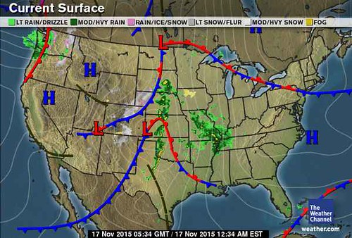
The Jupiter-Neptune opposition of September of this year was triggered on November 17th. Since the opposition fell over California and the Pacific Northwest, I expect rain to visit the area. The National Weather Service reported on November 17th that heavy rain was possible over parts of the Cascades due to a wave of low pressure coming from the Pacific Ocean. Showers and higher elevation snow was to push into the Pacific Northwest and the Intermountain West. Below, the Weather Channel map for the 17th shows the front and rain.


Nov 16


The next forecast period was that of November 25-30. I expected strong storms or a series of fronts to deliver rain to California and the surrounding area. On the 24th, Winter Weather messages were posted by the National Weather Service for Oregon and northern and central California. Brief blizzard conditions were experienced throughout the area. The main event that was experienced for the rest of the forecast period was windy and cold conditions that affected the forecast area due to a cold upper level low that stationed itself over the Great Basin area. A number of wind advisories and freeze warnings were issued during the forecast period for California.

On the last day of the forecast period (30th), rounds of storms began to impact Washington, Oregon, and California. These storms continued throughout the first week of December.

The hurricane forecast called for possible tropical activity south of Louisiana in the Gulf and also around the Turks and Caicos Islands from November 24-27. No hurricane activity was reported over the Islands. No tropical system developed in the Gulf either, however, on the 26th  the National Weather Service reported that moisture was spreading northward from the Gulf of Mexico causing rainfall amounts of 3 to 9 inches, with locally higher amounts, from central and southern Texas to the mid-Mississippi Valley. On the 27th, two to five inches of rain affected the lower and middle Mississippi Valley. Over the next few days flash flooding continued over the lower Mississippi Valley. My take on this is that the planetary alignment between Saturn and Neptune that I expected could be indicative of a tropical system, was, nevertheless fulfilling its moisture-enhancing function that astro-meteorology recognizes it has by feeding moisture from the Gulf in to the area.


Links to Other Long-range Weather Forecasts and Forecast Results

Hurricane Dolores Fulfills Long-range Weather Forecast
Hurricane Season 2015 Long-range Weather Predictions
Tropical Cyclone Hadi
Hurricane Erick Fulfills Long-range Forecast
Tropical Storm Andrea Fulfills Long-range Forecast!
Timing the Relief for Drought-Stricken U.S. Plains
Testing Astrometeorology Part 2
Hurricane Sandy Fulfills Long-range Weather Prediction!
Testing Astrometeorology Part 1
Hurricane Season 2011 Forecast Results
Hurricane Risk-Management
New Weather Alternative Website
Fulfilled Long-range Forecasts for Hurricane Season 2010
Introduction to the Weather Alternative
Abortion Rate at Lowest Since Roe vs. Wade  


Saturday, October 24, 2015

California Drought Forecast November 2015

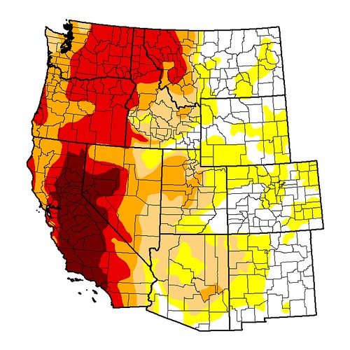
Recent long-range California drought forecasts posted at the end of August 2015 have been successful in timing the arrival of needed rain. You can read the results here, here, and here. The latest drought monitor map, however, shows that the state is still in the grips of a serious water shortage.

20151020_west_none
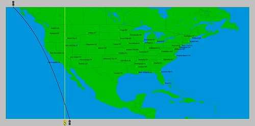
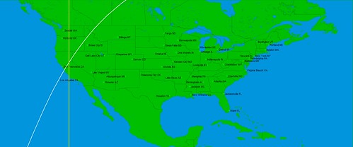
Some major planetary aspects that are associated with abnormally damp weather and above normal precipitation are taking place over California. The first one on September 17th of this year (Jupiter opposition Neptune) will be triggered again during the last week of November. In addition to this, on the 17th of November, the Sun-Mercury conjunction will combine with the upcoming Saturn-Neptune square over California as shown in the map below. Saturn-Neptune combinations are known for increased precipitation.


Nov 17

The effects of this alignment may begin to be felt around the 17th, but a stronger period should be that of November 25th through the 30th when the potential is high for strong storms or a series of fronts to trigger precipitation over California and surrounding areas. Let's hope they get the rain they need.

As you may know there is a controversy over Nestle extracting water from the state of California during a drought. You can read what activists are saying here, and what Nestle says here.


Links to Other Long-range Weather Forecasts and Forecast Results

Hurricane Dolores Fulfills Long-range Weather Forecast
Hurricane Season 2015 Long-range Weather Predictions
Tropical Cyclone Hadi
Hurricane Erick Fulfills Long-range Forecast
Tropical Storm Andrea Fulfills Long-range Forecast!
Timing the Relief for Drought-Stricken U.S. Plains
Testing Astrometeorology Part 2
Hurricane Sandy Fulfills Long-range Weather Prediction!
Testing Astrometeorology Part 1
Hurricane Season 2011 Forecast Results
Hurricane Risk-Management
New Weather Alternative Website
Fulfilled Long-range Forecasts for Hurricane Season 2010
Introduction to the Weather Alternative

Ohio Senate Moves to De-fund Planned Parenthood (read here)

defund-PP-850x478

Tuesday, October 20, 2015

October 9-11, 2015 Hurricane Forecast Results

The next forecast that appeared in my Dell Horoscope article entitled Celestial Storm Warnings! - Predicting the 2015 Hurricane Season in the June 2015 edition centered on the Florida area and East Coast.

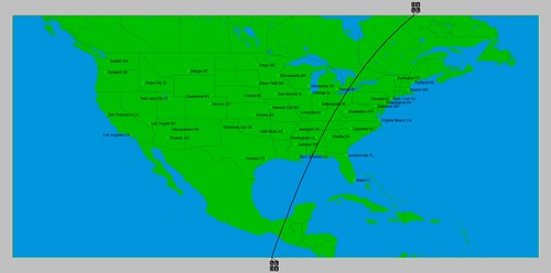
This forecast was based on Mercury's retrograde station of October 9th which placed important planetary influences over the Southeast U.S. especially Florida as can be seen in the astro-locality map below.

Florida

The forecast called for either a tropical system to affect Florida and travel up the coast or severe thunderstorms over the peninsula.

Results

According to the Weather Prediction Center's Short Range Forecast Discussion of October 9th, heavy rain was forecast to hit eastern Georgia and the Carolinas. Flash flooding affected some areas. The low pressure area responsible for the rain was then to stall offshore.


Links to Other Long-range Weather Forecasts and Forecast Results

Hurricane Dolores Fulfills Long-range Weather Forecast
Hurricane Season 2015 Long-range Weather Predictions
Tropical Cyclone Hadi
Hurricane Erick Fulfills Long-range Forecast
Tropical Storm Andrea Fulfills Long-range Forecast!
Timing the Relief for Drought-Stricken U.S. Plains
Testing Astrometeorology Part 2
Hurricane Sandy Fulfills Long-range Weather Prediction!
Testing Astrometeorology Part 1
Hurricane Season 2011 Forecast Results
Hurricane Risk-Management
New Weather Alternative Website
Fulfilled Long-range Forecasts for Hurricane Season 2010
Introduction to the Weather Alternative
Global Cooling: Is an Ice Age Coming?