On the 13th of June, Neptune will make its retrograde station which is a key event in triggering the above mentioned atmospheric conditions. The 17th of June features the square aspect between Saturn and Neptune which also excites deep low pressure systems that result in higher than average rainfall. Then, on the 20th of June, Mercury will oppose Saturn and square Neptune activating their influence once again. In a minute we'll look at the areas that will be affected this year. But first, let's see what happened to atmospheric conditions the last time Neptune made it retrograde station and the last time Saturn squared Neptune.
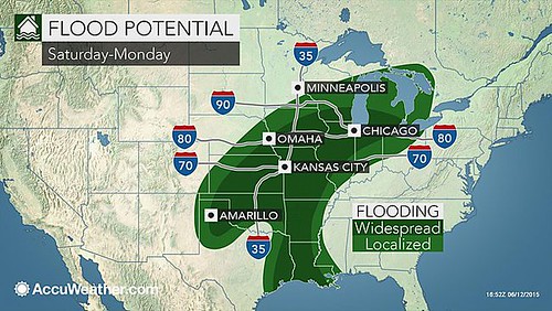
On June 12, 2015, Neptune made its retrograde station. In the key seasonal chart, Neptune's influence affected the eastern Plains states roughly from Louisiana northward through Minnesota. As can be seen from the Accuweather map below this is the exact area that experienced widespread localized flooding from June 13-15, 2016. This was in part due the Tropical Storm Bill that hit Texas at that time and continued northward.

The last Saturn-Neptune square occurred on November 26, 2015. Neptune's influence affected the Mississippi Valley and eastward while Saturn's influence affected the Eastern Seaboard. The National Weather Service forecast for Nov 27-29, 2015 warned, "Flash flooding possible across portions of the southern plains and mid-Mississippi valley." Their forecast for Nov 29th stated, "Scattered to numerous rain showers is forecast northeast Texas to central Virginia where 3-day totals of 1 to 5 inches will be possible. Locally higher amounts may be observed in eastern Tennessee and western North Carolina."
Forecast
This year Neptune will occupy the 82nd line of west longitude running from Florida through Ohio. This area will likely be subjected to heavy rainfall that produces widespread flooding as we've seen in last year's example. Since we're in hurricane season, we can rule out a tropical system at this time. The weather pattern will then travel eastward and affect the US East Coast.
In other key charts, the US West Coast is also affected by Neptune and Saturn. June is not as rainy as other months out west but we may see some anomalous weather pattern develop over the Pacific Northwest especially around the end of the forecast period (19th - 21st). This may be something like a dramatic increase in temperatures and humidity or an anomalous low pressure system.
Links to Other Long-range Weather Forecasts and Forecast Results
June 1-5, 2016 Long-range Weather Forecast
Hurricane Dolores Fulfills Long-range Weather Forecast
Hurricane Season 2015 Long-range Weather Predictions
Tropical Cyclone Hadi
Hurricane Erick Fulfills Long-range Forecast
Tropical Storm Andrea Fulfills Long-range Forecast!
Timing the Relief for Drought-Stricken U.S. Plains
Testing Astrometeorology Part 2
Hurricane Sandy Fulfills Long-range Weather Prediction!
Testing Astrometeorology Part 1
Hurricane Season 2011 Forecast Results
Hurricane Risk-Management
New Weather Alternative Website
Fulfilled Long-range Forecasts for Hurricane Season 2010
Introduction to the Weather Alternative
No comments:
Post a Comment