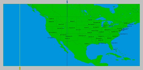
Between the 19th and 22nd of October 2015, the planets Venus and Mars entered into a configuration that added impetus to the alignment of Jupiter and Uranus that was already underway. The locality map below shows that Uranus was positioned over the Rocky Mountains at about 110 west longitude while Jupiter was placed over the eastern Pacific at 141 west longitude.
On the 18th, the National Weather Service warned that a deep trough and upper level low would affect the western U.S. with the heaviest activity from northern Arizona to the northern Rockies where 1 to 2 inches of rain or higher could lead to flash flooding.
For the 20th, the forecast was for additional heavy rains for the Southwest and south-central Rockies.
Flash flooding was called for on the 21st for portions of the Southwest and Southern High Plains. The NWS warned of a stationary boundary over the Four Corners region and anomalous pools of moisture to increase the likelihood of heavy rain and/or intense rainfall over the region on the 22nd. Further south, Hurricane Patricia, with sustained winds of 200 mph, was being drawn toward the Uranus line at 110 west longitude.
April 2016
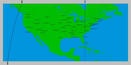
The next locality map shows the positions of Jupiter and Uranus during April 2016. Jupiter is represented by the blue line over the eastern U.S. at approximately 79 west longitude, while Uranus is shown by the black line off the U.S. West Coast.
April 6-10, 2016
Between these dates the Sun will participate in the Jupiter-Uranus configuration adding important energy to the mix. The potential exists for a strong front to move into the West Coast states bringing precipitation. The eastern portion of the country should see a strong cold front that ignites storm activity from the eastern Great Lakes through the Mid-Atlantic area as it moves eastward.
April 22-25
At this time Venus aligns with the Jupiter-Uranus configuration and is likely to represent another round of fronts for the West Coast states and the eastern U.S.
Links to Other Long-range Weather Forecasts and Forecast Results
March 2016 Long-range Weather Forecasts
Hurricane Dolores Fulfills Long-range Weather Forecast
Hurricane Season 2015 Long-range Weather Predictions
Tropical Cyclone Hadi
Hurricane Erick Fulfills Long-range Forecast
Tropical Storm Andrea Fulfills Long-range Forecast!
Timing the Relief for Drought-Stricken U.S. Plains
Testing Astrometeorology Part 2
Hurricane Sandy Fulfills Long-range Weather Prediction!
Testing Astrometeorology Part 1
Hurricane Season 2011 Forecast Results
Hurricane Risk-Management
New Weather Alternative Website
Fulfilled Long-range Forecasts for Hurricane Season 2010
Introduction to the Weather Alternative
No comments:
Post a Comment