 These forecasts were posted on December 22, 2009.
Forecast
January 4-5
A storm system develops along the east side of the Rockies as moist air, drawn from the Gulf, collides with cooler air from the north. One scenario is that the storm system ejects into the Plains bringing cold and windy conditions behind the low. Or the cold and windy conditions may be the result of a front stretching from the central Plains to the western Great Lakes.
Results
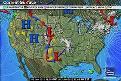
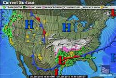
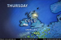
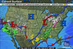
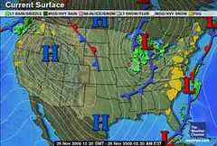
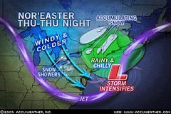
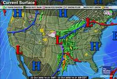
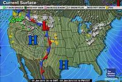
The above map is from the Weather Channel for January 5th. You can see the low along the east side of the Rockies over Montana and Wyoming. This later ejected (on the 6th) into the Plains. Very cold and windy conditions were behind the low and a front stretched from the southern Plains to the Western Great Lakes on the 7th. Temperatures in the Plains were in the single digits and teens.
Forecast
January 7-10
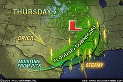
Warm, moist air begins to move northward over Texas and the southern Plains around the 7th bringing a chance of showers. By the 9th, the potential for storminess is heightened. Most of the activity may be over Texas.
Results
There were some showers over the coastal areas of Texas on the 7th, but the main event at this time was bitter cold from the 7th to the 9th. By the 10th, temperatures were 10 to 30 degrees higher.

Cold air invades the Plains out of Canada creating stormy conditions as a powerful cold front pushes westward.
Results
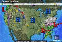
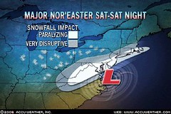
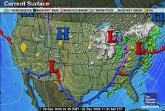
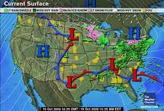
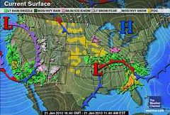
The Weather Channel map at right is for January 27th and shows a cold front entering the Plains. . By the 28th, this met up with a low over western Texas that developed into an ice storm over the southern Plains and the northern part of the cold front, connected to a low pressure system, intensified over the northeast U.S. bringing another blast of winter.
Rockies
Forecast
January 2-5
The arrival of warm, moisture-laden air over the Rockies on the 2nd and 3rd will battle with a cold Canadian air mass resulting in windy conditions or a storm center producing winds.
Results
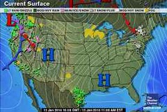
(Refer to the first weather map of this post for January 5th) Windy conditions over the Rockies were reported as follows:
January 5th (Accuweather)
Gusty winds whipped the snow around across Montana. Whitewater, Mont., received 4.0 inches of snow, but winds created 2- to 3-foot high drifts.
January 5th (National Weather Service)
Albuquerque, NM
6:01 am MST, Tue., Jan. 5, 2010
THE COLD FRONT WILL BE ACCOMPANIED BY STRONG NORTHERLY WINDS OF 25 TO 35 MPH WITH GUSTS OF 40 TO 50 MPH.
Grand Junction, CO
8:07 am MST, Tue., Jan. 5, 2010
WINDS OF 15 TO 25 MPH WITH HIGHER GUSTS WILL CAUSE SOME BLOWING AND DRIFTING OF SNOW.
 Forecast
January 7
A sharp cold front pushes southward over the Rockies lowering temperatures.
Results
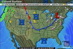
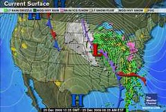
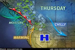
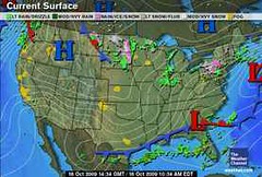
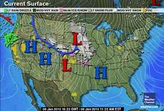
The Weather Channel map at left is for January 6th. Accuweather reported "A new blast of arctic air plunged into the northern Rockies and northern Plains on Wednesday (Jan 6th)."
Forecast
January 10
A trough of low pressure digs into the southern Rockies.
Results
On the 10th, the Weather Channel reported that a storm system was headed toward the southern Rockies and would arrive around the 12th and 13th. In their own words, "A second storm system helps push the rain and snow toward Southern California and the Southwest Tuesday night and Wednesday."
 Forecast
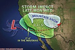
January 21-22
A fresh push of cold air over the Rockies will react with its warm, moist counterpart resulting in a storm system.
The Weather Channel reported on the 21st:
Stormy conditions will rule the West right through Friday as the jet stream remains pointed at the region like a fire hose.
The brunt of the activity will be focused from California to portions of Nevada, Utah, western Colorado, Arizona, and New Mexico.
 Forecast
January 24-25
Another period when contrary air masses clash over the Rockies resulting in showers.
Results
A storm system arrived late on the 25th and pushed into the Four Corners region spreading snow in the mountains on the 26th and 27th.
 Forecast
January 13-16
Inclement weather will plague the Intermountain West as a strong front or low pressure area ushers in wind, rain, and snow.
Results
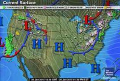
January 13 Accuweather
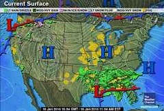
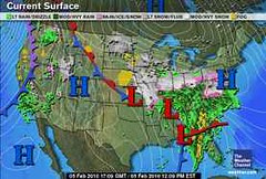
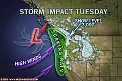
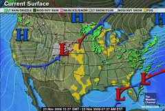
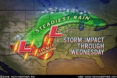
A more potent storm pushed rain and mountain snow from the West Coast into the Intermountain West…As the storm pressed into the Intermountain West and high pressure moved inland, gusty offshore winds developed over parts of Southern California. The above Weather Channel map is for January 13th.
 Forecast
January 21-24
Another batch of wind and rain heads toward the Pacific Northwest and into the Intermountain West.
Results
The Weather Channel map at left is for January 22nd. This was a very active time which actually started on the 17th. Here are some of Accuweather's headlines for the 21st through the 24th.
January 21
The latest storm to hit the West has been the strongest so far this month, breaking barometric pressure records along the coast.
January 22
Up to 8 Feet of Snow from West Storm
January 24
Farther west, another storm pressed onshore in the Pacific Northwest. By the afternoon, windswept rain soaked the coast from central California to Washington, while snow began piling up in the mountains.
 Forecast
January 26-31
An active weather pattern develops off the Pacific Northwest coast and hurls wind and rain in Washington, Oregon, and California. It appears that a number of fronts will ride through the area between these dates and push into the Intermountain West.
Results
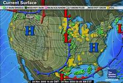
This Weather Channel map is for January 26th. Accuweather's reported that a new Pacific storm returned rain to southern California. On the 28th, some spotty rain, freezing rain, and snow fell over Washington, Oregon, and northwestern California. On the 29th, a new storm delivered rain to the Pacific Northwest and northwestern California. And on the 30th, a storm spread some showers and mountain snow across the Pacific Northwest.
Introduction to the Weather Alternative
How Long-Range Forecasts Are Made
Saint Patrick's Day 2010 Weather Forecast
What Is Greatness?
Do not confuse notoriety and fame with greatness. Many of the titled in today's world obtained their fame and fortune outside their own merit.
On the other hand, I have met great people in the most obscure roles. For greatness is a measure of one's spirit, not a result of one's rank in human affairs. Nobody, least of all mere human beings, confers greatness upon another, for it is not a prize but an achievement. And greatness can crown the head of a janitor just as readily as it can come to someone of high rank.
--Sherman G. Finesilver