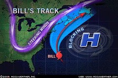
Hurricane Bill's track has pretty much followed the track that I pointed out in a recent post entitled Where Are the Atlantic Storms Headed?
This track took it north toward Nova Scotia but not close enough to the U.S. East Coast to be much of a problem.
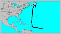
Here is my crude little hand-drawn map showing the track headed toward Nova Scotia and Newfoundland. I did expect Bill to come closer to the Lesser Antilles then it did.
 A recent Weather Alternative post from July 31st entitled Atlantic Hurricane and Southern Texas Rain made a number of forecasts regarding upcoming hurricane activity in the Atlantic and Pacific Basins as well as forecasts regarding rain for southern Texas. Here's how the forecasts have shaped up.
I expected the Atlantic hurricane season to really get kick in between August 17-19. Things really started to get underway on the 15th with the formation of Tropical Storms Ana and Bill--a bit earlier and further west than I forecast.
Another area I expected to experience strong storms was the Arizona-New Mexico region around the same dates. There have been no storms, just high heat and wildfires further west.
From the 19th to the 21st I forecast rain for southern Texas. The only thing the atmosphere delivered at this time was isolated showers along the southern Texas coast on the 18th and 19th. I did mention that there was a chance of of things staying hot and dry with the planetary pair involved, but I was hoping for the needed rain.
In re-studying key charts that might be involved in producing this extreme drought, I've come across what I think may be the culprit. The Solar Eclipse of Sept 11, 2007 places Mars, the author of heat and dryness, over this area of the country. I'm beginning to see that as long as this chart is active, or until another key chart replaces this one as occasionally happens (see Beneficial Rain for Texas), we might not see much drought relief. When this might happen is a project I'll be working on.

Solar Eclipse Action for August and September 2009
Introduction to the Weather Alternative
How Long-Range Forecasts Are Made
Where is Hurricane Bill Headed?
Motives
How our smallest efforts are magnified when the motives behind them are unselfish!--Francis Gay
No comments:
Post a Comment