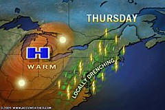
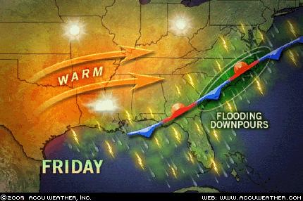
 The Weather Alternative's long-range weather forecast for August 14th and 15th was posted on July 20th. Planetary alignments between Mercury, Venus, and Saturn were cited as the astrometeorological factors behind a storm system (possibly tropical in nature) that would affect the East Coast States of North Carolina, Maryland, Delaware, Pennsylvania, and New Jersey. Locally drenching rains moved into the Northeast and Mid-Atlantic on Thursday the 13th of August.
Thunderstorms dumped 2.72 inches of rain on Norfolk closing sections of Interstate 264. Flooding also occurred in Millville, N.J., Andover, N.Y., and Bridgeton, N.J.
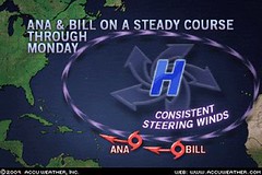
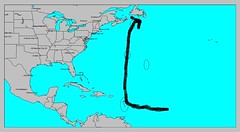 Here are some observations of where some of these tropical systems might be headed. Between the 21st and 26th of August some very nasty planetary alignments take place. These frequently have coincided with hurricane or tropical storm systems. These aspects are Mercury opposition Uranus, Mercury square Mars, Mercury square Pluto, and Mars opposition Pluto. The map at right shows where the majority of these aspects play themselves out in certain key charts. The basic idea being that around the 21st the Lesser Antilles are in for some tropical storm or hurricane activity. This would probably coincide with Bill's passage at this time. The rest of the aspects between Mercury, Mars, and Pluto affect the area north of the islands up toward Nova Scotia. Perhaps Bill, or some other tropical system, will then head northward from there.
Another place that might show signs of tropical storm development or where a tropical system may pass through is about 240 miles south of Hispaniola around 70 west longitude and 15 north latitude.
A previous post entitled Solar Eclipse Action for August and September 2009 also contains other forecasts for both the Atlantic and Pacific during the period between August 22-26. The central Gulf is highlighted for possible tropical storm or hurricane activity then.
Atlantic Hurricane and Southern Texas Rain
Solar Eclipse Action for August and September 2009
August 10-15, 2009
Introduction to the Weather Alternative
How Long-Range Forecasts Are Made
Charity
With malice toward none, with charity for all. --Abraham Lincoln
Charity should begin at home, but should not stay there. --Phillip Brooks
The best thing to give to your enemy is forgiveness; to an opponent, tolerance; to a friend, your heart; to your child, a good example...to all men, charity. --Francis Maitland Balfour
2 comments:
I hope the storms weaken and stay away from us.
Well, Lisa, Bill may strengthen but I think it might take the path I've outlined and stay away from the U.S. Let's hope so.
Ken
Post a Comment