 The recent severe weather sustained over the Central and Northeast U.S. fulfilled The Weather Alternative's long-range forecast for August 10-12, 2009. The forecast, posted on July 20th, cited the Mars-Saturn square as a severe weather breeder for the area in and around Kansas, Nebraska, and Missouri. Pennsylvania and West Virgina were also pinpointed for strong storms.
The outbreak began as early as the 9th. Accuweather reported the following: Lycoming Co., Pa., was one place that was hit hard by the severe weather. The thunderstorms downed large trees throughout the county. These trees caused additional destruction by landing on numerous homes and cars. Trees littering Route 44 forced officials to close the road.
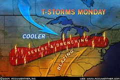
They also warned that Monday, the 10th of August, would bring more of the same: Places from upstate New York, northern Pennsylvania and portions of New England all the way to Kansas could be dealing with locally violent storms, especially during the afternoon and evening on Monday.
These are the exact locations (Pennsylvania and Kansas) that were mentioned in the long-range forecast.
The area of concern into tonight (Aug 10th) stretches from the northern Texas Panhandle, eastern Colorado and much of Kansas Kansas to Southwest Ontario, New York State, Pennsylvania, New Jersey and southern New England. As a cold front and the associated upper level trough swing eastward Tuesday, the storms will focus from Tennessee and Arkansas to southern Maine, southward to much of Virginia.
The National Weather Service reported the following on August 10th:
SEVERE WEATHER STRUCK PARTS OF NORTHERN AND CENTRAL KANSAS DURING THE LATE MORNING...PRODUCING DAMAGING WINDS...HAIL AND HEAVY RAIN. HAIL TO THE SIZE OF HALF DOLLARS WAS REPORTED FROM ONE STORM 6 MILES SOUTH OF ZURICH IN ROOKS COUNTY KANSAS AT 9 AM.
SHOWERS AND THUNDERSTORMS DEVELOPED OVER NORTHEAST COLORADO NEAR MIDNIGHT...AND THEN SPENT A GOOD PART OF THE LATE NIGHT AND EARLY MORNING HOURS OVER SOUTHWESTERN NEBRASKA. THE MOST INTENSE STORMS OCCURRED IN SOUTHERN CHASE COUNTY...WHERE AS MUCH AS 1.62 INCHES OF RAIN WAS REPORTED 5 MILES SOUTH OF ENDERS...THEY CAUSED WINDS TO GUST AS HIGH AS 47 MPH IN THE NORTH PLATTE AREA JUST BEFORE 7 AM CDT.
Atlantic Hurricane and Southern Texas Rain
Solar Eclipse Action for August and September 2009
August 10-15, 2009
Introduction to the Weather Alternative
How Long-Range Forecasts Are Made
Black Bart
A dropped handkerchief: a surprising end to the career of California's most colorful stage-coach robber. "Black Bart" had terrorized stages for six years, committing twenty-eight robberies between 1877 and 1883 in the rugged foothills of the Sierras. Dressed in a long linen duster with a flour sack over his head, he would brandish a shotgun while demanding, "Will you please throw down your treasure box, sir?"
Finally, near Copperopolis, Bart was wounded while escaping a holdup and dropped a handkerchief with the laundry mark "FX07." This was traced to San Francisco, where police made one of the most surprising arrests in the city's history. "Black Bart," the highwayman, turned out to be Charles E. Bolton, one of San Francisco's leading citizens with close connections in the police department.
Bolton had a reputation as a non-smoking, non-drinking, God-fearing man with big business interest in the gold mines. Amid much publicity he confessed his crime and was sentenced to six years in San Quentin for his deception.
No comments:
Post a Comment