Saxby's Weather System was publised in 1864. The author, Stephen Martin Saxby, presented his case for lunar influence on earthly weather. He summed things up in the following words:
"I found that the moon never crosses the earth's equator or reaches her poisition of stitial colure (maximum declination north or south of the equator), without a marked disturbance of the atmosphere occurring at the same period."
What kind of weather did Saxby expect when the moon reached theses key positions? "...such changes most commonly are accompanied either by strong winds, gales, sudden frosts, sudden thaw, sudden calms, or other certain interruptions of the weather, according to the season."
Saxby realized that this "key" was just part of the weather picture and could not pinpoint the places where such weather phenomena would take place when he stated "It is too much to expect of me that I can define the terrestrial limits of any results which at certain times may present themselves under lunar influences...All I can do at present (or at least all I at present feel justified in declaring, with some exceptions) is that certain periods named in my lists will be times of change."
Saxby considered that these atmospheric changes could take place over a four day period i.e. the day before, the day during, and until two days after the aforementioned lunar positions.
Of course, we know that much more goes into forming our weather than that, but Saxby was on to something. It seems that powerful weather systems are somehow linked to these times. Out of curiosity, I picked the dates of some major storms and hurricanes and checked the lunar positions. All of them coincided with Saxby's allowable window of influence. Here they are:
Hurricane Andrew
August 24, 1992
Moon at maximum north declination on August 22 1992
Hurricane Katrina
August 29, 2005
Moon at maximum north declination on August 28, 2005
Tsunami
December 26, 2004
Moon at maximum north declination and at Full Moon December 26, 2004
Blizzard of '93
March 12-13, 1993
Moon at maximum south declination on March 14, 1993
Hurricane Wilma pounds the Yucatan Peninsula
October 21-23, 2005
Moon at maximum north declination October 22, 2005
Friday, March 10, 2006
Saturday, March 04, 2006
March 1-4, 2006 Forecast Results
The Weather Alternative bases its forecasts on Johannes Kepler's long-range forecast system. Planetary cycles are at the heart of Kepler's method and enable its practitioners to venture forecasts much further into the future than conventional meteorology can at present. The following forecast, posted on February 16, 2006, and its results are an example of the accuracy that can be attained by this method.
Having worked with this system for a number of years, I never cease to be amazed at the beauty and the "down-to-earth" practicality that its designer bestowed upon the heavenly bodies. The members of our solar system no longer appear to be unrelated and meaningless masses of rock and gas circling the sun as science sometimes leaves us feeling. But God has given purpose to the planets and equipped his offspring with a built-in, environmentally safe, long-range weather forecasting tool for our service.
Forecast:
March Comes in Like a Lion
March 1-4, 2006:
A major winter storm will roar into the Pacific Northwest and Northern California on gusty winds. Its trek through the Great Basin and Rockies will provoke falling temperatures and prompt winter storm warnings and high wind advisories.
Results
Accuweather displayed the following weather map on Tuesday, February 28th.
 Graphic courtesy of accuweather.com
February 28, 2006
The Weather Channel
By afternoon, western Washington, western Oregon and northern California will come under assault from a Gulf of Alaska storm as rain and wind spread eastward. Late tomorrow and tomorrow night, the heaviest rains and mountain snows will smack southwestern Oregon and northern California while strong, gusty winds lay into the Oregon and northern California coasts.
March 1, 2006
The Weather Channel
Many in the West will be in between systems today, as one spreads showers and snow through the central and southern Rockies, while the next system targets the Northwest. A few showers and higher elevation snow will fall, especially across the Colorado Rockies.
March 3, 2006
The Weather Channel
A new western storm system will take aim on California today.
Forecast:
An intense cold front will usher in cold Canadian air that will lower temperatures, and rev up winds that will result in strong storms over the Plains.
Results
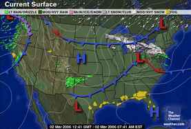
Accuweather displayed the following weather map on February 28, 2006.
 Graphic courtesy of accuweather.com
March 1, 2006
Accuweather
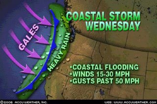
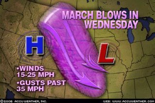
The combination of the storm system moving east and high pressure building over the central Rockies is going to create strong winds across the Plains States. AccuWeather.com is forecasting wind speeds will average 15-25 mph, but there will be gusts of up to 35 mph, and some areas could also see experience gusts topping 50 mph on Thursday afternoon (March 2nd).
March 2, 2006
The Weather Channel
Midwest
With cool high pressure settling over the region, high temperatures today will be noticeably cooler; in some cases about 15 to 20 degrees cooler.
Forecast:
A significant storm will also batter the Northeast and New England as warm, moist air is pulled up over the region, particularly around the 4th. Due to the incursion of southerly moisture, precipitation may mostly manifest as rain.
Results
March 2, 2006
Accuweather
WINTER STORM CREATES HAVOC IN NORTHAST
The late-winter storm rolling through the Northeast has closed schools and caused travel problems.
Senior Meteorologist Gerald Mohler...is forecasting today's target for the heaviest snowfall will be extreme northeastern Pennsylvania and the southern tier of New York state, with 8 to 9 inches of snow likely to fall in that area.
According to Mohler, the warm air from the South has pushed well into the Northeast, keeping much of the precipitation in this system in the form of rain, freezing rain and sleet. The snow is falling across north-central Pennsylvania and central New York, while the greater Philadelphia area is receiving mostly freezing rain.
Mohler is forecasting temperatures across the southern edge of the storm will push above the freezing mark by mid-morning, and the precipitation will change to all rain.
March 2, 2006
Weather Map courtesy of the Weather Channel
March 4, 2006
The Weather Channel
Northeast
A strong and persistent area of low pressure in the Maritimes of Canada will keep a cold northwesterly flow of air across the region. Winds may gust from 35 to 40 mph at times. Wind chills throughout the region will hover in the teens and twenties this afternoon. Moisture moving back around the Maritime low will back down through Quebec into parts of Vermont and New Hampshire and several inches of snow may accumulate. A heavy snow warning is in place for northern Vermont until Sunday morning. Meanwhile, snow showers may fall in areas near Lakes Erie and Ontario.
Subscribe to:
Posts (Atom)