Sunday, June 30, 2013

Plains Drought Relief Results

Here are some results of the long-range weather forecasts made back on February 10th of this year regarding drought relief for the U.S. Plains states. The results of the first forecasts for the winter season were posted here and here.

Let's look at how the forecasts for the spring of 2013 turned out.

The first forecast call for the possibility of rain around May 13th due to the square of Venus to Neptune. There was a phenomenal surge of heat over the central Plains (also a characteristic of Venus-Neptune) on the 14th but moisture largely bypassed the Southern High Plains.

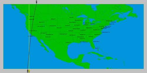
The next date mentioned for precipitation was the period around May 17th. According to the Weekly Weather and Crop Bulletin, a significant tornado outbreak afflicted the Plains between the 17th and 20th. Locally heavy rain hit the Dakotas and Minnesota. Heavy showers accompanied the severe weather outbreak. More than 2 inches of rain hit Oklahoma City, OK, and Chanute, KS on the 20th. Locally heavy rain also extended southward into parts of Texas. The Weather Channel map below is for May 19th.
May 19

The next time period mentioned was around May 26th when the Sun completed its square to Neptune. On May 27th, the Weekly Weather and Crop Bulletin reported that Lincoln, NE received 3.32 inches of rain, while Kansas City, MO racked up 2.26. On the 26th, Huron, SD received 1.91 inches. May 28th brought a record-setting 3.77 inches to Fargo, ND, and 2.77 inches to Salina, KS. Marshalltown, Iowa, netted 8.98 inches between May 25-29. The Southern High Plains didn't fare as well as moisture once again bypassed the area.

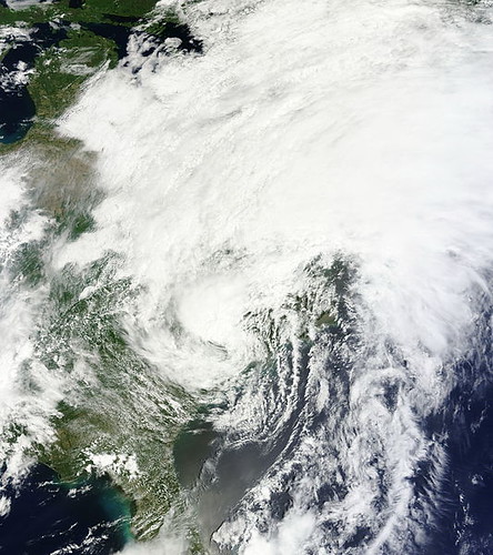
The last forecast was for the period around June 7th when Mars made its square to Neptune. On the 7th and 8th a storm rolled out of the Rockies into the Plains affecting from South Dakota down to Kansas and over to Iowa. (See the Weather Channel map for the June 8th below) The storms then shifted from the eastern Plains to the Mississippi Valley bringing some 1-inch-or-greater downpours.
May 19

Hurricane Season 2013 Part 1
West Coast Weather July-August 2013
Tropical Storm Andrea Fulfills Long-range Forecast!
California Water Shortage Part 2
California Water Shortage Spring 2013 Forecast
Timing the Relief for Drought-Stricken U.S. Plains
Testing Astrometeorology Part 2
Hurricane Sandy Fulfills Long-range Weather Prediction!
Testing Astrometeorology Part 1
Long-range effects of the May 20, 2012 Solar Eclipse
Long-range effects of the May 20, 2012 Solar Eclipse Part 2
Hurricane Season 2011 Forecast Results
Hurricane Risk-Management
New Weather Alternative Website
Overview of UK Winter 2012-13
The Winters of 2011-14
Fulfilled Long-range Forecasts for Hurricane Season 2010
Introduction to the Weather Alternative

Saturday, June 22, 2013

Hurricane Season 2013 Part 1

Here are a few areas where tropical systems may strike in the near future. These long-range forecasts are based on planetary cycles.

Retired_Atlantic_hurricane_tracks

July 4-11, 2013
The seven-day period from July 4-11, 2013 may bring some tropical activity due to planetary cycles involving the Sun, Mercury, Saturn, and Uranus. The areas in and around Tampico, Mexico (99 west/22 north) and Acapulco, Mexico (99 west/16 north) are highlighted. There are indications that eastern Texas may also experience severe weather at this time, which may be of a tropical nature. The New England area also stands the chance of experiencing a severe weather pattern, perhaps a tropical system.

August 7-12, 2013
Around this time planetary cycles involving the opposition between Jupiter and Pluto, and the square between Mercury and Saturn are active. The Solar Eclipse of May 9, 2013 will also be triggered now. One of the areas where these influences concentrate is southern Mexico. Tropical moisture or an actual tropical system originating in either the Bay of Campeche or the Gulf of Tehuantepec will affect this southernmost portion of Mexico. Another possible scenario involves a tropical system that travels the length of the U.S. East Coast on its way to the Northeast and New England.

August 21-24, 2013
At this time we're dealing with the square between Jupiter and Uranus which are known for exciting high wind velocities. Sounds like a hurricane. Most of the key charts place this influence, once again, over the Northeast U.S. and New England. This could mean a tropical system or other type of severe weather that brings high velocity winds.

West Coast Weather July-August 2013
Tropical Storm Andrea Fulfills Long-range Forecast!
California Water Shortage Part 2
California Water Shortage Spring 2013 Forecast
Timing the Relief for Drought-Stricken U.S. Plains
Testing Astrometeorology Part 2
Hurricane Sandy Fulfills Long-range Weather Prediction!
Testing Astrometeorology Part 1
Long-range effects of the May 20, 2012 Solar Eclipse
Long-range effects of the May 20, 2012 Solar Eclipse Part 2
Hurricane Season 2011 Forecast Results
Hurricane Risk-Management
New Weather Alternative Website
Overview of UK Winter 2012-13
The Winters of 2011-14
Fulfilled Long-range Forecasts for Hurricane Season 2010
Introduction to the Weather Alternative

Saturday, June 15, 2013

West Coast Weather July - August 2013

In recent posts, I've talked about how important planetary alignments can be triggered later on by aspects of the outer planets Mars, Jupiter, Uranus, Neptune, and Pluto. There is then a weather reaction over the areas where the original alignments took place. See Mars-Saturn and Jupiter-Neptune.

The Uranus-Pluto square of May 20, 2013, placed special influence over the U.S. Pacific Northwest, California, and eastern Pacific. Here's an astro-locality map showing where these two planets left their mark.


Ur Pl


The original square on May 20th brought showers and thunderstorms to the Pacific Northwest. The storm system stalled and engendered about 5 days of cool and showery weather. When Mercury squared this degree on June 8, there were windy conditions over the forecast area. When Venus hit it on June 12, there were showers and t-storms due to an upper level low. In this post, however, we want to look at triggers from the outer planets, which are more powerful.
Before we do that, another important influence that will be at work over the West Coast states is shown in the key chart for the summer of 2013. A Mercury-Venus conjunction will also fall over this area on June 21st as the summer season begins. The following astro-locality map gives shows the area of influence.  

Summer 2013

You can see how the line in this map overlaps the line in the first map over northern California. Now, we'll look at some dates when the outer planets trigger the Uranus-Pluto square while other planets are simultaneously activating the Mercury-Venus conjunction in the second map.

July 1-2, 2013

On the 1st, Mercury will retrograde over the Mercury-Venus conjunction while on the 2nd, the Sun will activate the Uranus-Pluto square. Of course, the Sun is not an "outer planet" but it is an important influence in the study of astrometeorology.


The Sun’s square to Uranus lowers temperatures and excites gusty winds. The Sun’s opposition to Pluto increases storminess. As Mercury retrogrades over the Mercury-Venus conjunction, windy conditions and a warm, moist air mass from the south are indicated. This may play itself out as a clashing of contrary air masses over the Pacific Northwest and northern California. It may manifest in and around these dates as a Santa Ana wind event or as a strong front that brings stormy conditions or wind.
 
July 30, 2013
Mars will reach the degree of the Uranus-Pluto square adding a more violent touch to the weather as Mars often does. This means there is the potential for severe thunderstorms or a powerful front that brings whipping winds. A tropical system may develop around this date or pass over 122 west longitude and 23 north latitude, which is about 800 miles west of Cabo San Lucas.

August 15-16, 2013

On the 15th, Mars will conjoin the Mercury-Venus line and on the 16th Jupiter will trigger the Uranus-Pluto square. Jupiter's action will most likely result in more increased wind velocities and lower temperatures. Mars' action, however, besides calling for windy conditions, indicates a southerly air flow. Together, they seem to provide the clash necessary to develop a severe weather pattern in the form of a low pressure system or front in and around these dates. The same area in the eastern Pacific (122 west/23 north) should be monitored for tropical activity.

Tropical Storm Andrea Fulfills Long-range Forecast!
California Water Shortage Part 2
California Water Shortage Spring 2013 Forecast
Timing the Relief for Drought-Stricken U.S. Plains
Testing Astrometeorology Part 2
Hurricane Sandy Fulfills Long-range Weather Prediction!
Testing Astrometeorology Part 1
Long-range effects of the May 20, 2012 Solar Eclipse
Long-range effects of the May 20, 2012 Solar Eclipse Part 2
Hurricane Season 2011 Forecast Results
Hurricane Risk-Management
New Weather Alternative Website
Overview of UK Winter 2012-13
The Winters of 2011-14
Fulfilled Long-range Forecasts for Hurricane Season 2010
Introduction to the Weather Alternative

Connecticut Approves GMO Labeling
 

Friday, June 07, 2013

Tropical Storm Andrea Fulfills Long-range Forecast!

The Weather Alternative long-range forecast posted about a month and a half ago is about to be fulfilled by what is now Post Tropical Cyclone Andrea. The forecast was issued on April 24th of this year entitled Ireland Weather June 5-10, 2013. The forecast analyzed a number of planetary cycles culminating during the first 10 days of June over Ireland and surrounding areas, and called for some impressive weather to follow.
Tropical_Storm_Andrea_2013-06-07_1611Z
Accuweather has reported today that the remnants of Andrea will arrive over Ireland starting on the night of the 10th bringing the strongest winds and heaviest rainfall across Ireland. Rain and locally strong winds will then spread across Scotland, Wales, and England on Tuesday and Wednesday (June 11th and 12th).

California Water Shortage Part 2
California Water Shortage Spring 2013 Forecast
Timing the Relief for Drought-Stricken U.S. Plains
Testing Astrometeorology Part 2
Hurricane Sandy Fulfills Long-range Weather Prediction!
Testing Astrometeorology Part 1
Long-range effects of the May 20, 2012 Solar Eclipse
Long-range effects of the May 20, 2012 Solar Eclipse Part 2
Hurricane Season 2011 Forecast Results
Hurricane Risk-Management
New Weather Alternative Website
Overview of UK Winter 2012-13
The Winters of 2011-14
Fulfilled Long-range Forecasts for Hurricane Season 2010
Introduction to the Weather Alternative

Sunday, June 02, 2013

Results for April 2013 Heat

The Weather Alternative forecast for April 17-22, 2013 spoke of the Sun-Mars conjunction and its effects on weather patterns. One of the areas to be affect by the conjunction was the Newfoundland/Labrador area of Canada. My forecast called for increasing temperatures, which are a key effect of the Sun-Mars combination, to give way to unsettled conditions.

Results for Canada

The Canadian weather office issued a wind warning on April 17th for areas of Newfoundland and Labrador. Potentially damaging winds were expected in these areas due to a low pressure system off the South Labrador Coast that would increase wind gust up to 100 km/h.


full-moon-13456161342DV

Another key area discussed in the long-range forecast was the U.S. West Coast. The Full Moon Chart of March 27th placed the Sun-Mars conjunction over California and the Pacific Northwest. My forecast called for warmer and drier conditions for this section of the country.

Results for U.S. West Coast

On April 17th, the National Weather Service explained in their Area Forecast Discussion for various areas of California that high pressure would build over the Great Basin area producing Santa Ana winds. The result would be warmer weather through April 20th through much of the state.

A number of other key charts indicated that a large portion of the United States would also see a warm up around this time.


Results for the eastern U.S.

At this time the Weather Channel reported the winter storm Yogi would affect the Plains and Midwest with severe storms and snow (see map below) and then shift its influence to the East Coast. More importantly, however, on April 17th, Accuweather posted an article entitled "Warm-Up Brings Allergy Woes to Northeast." They mentioned that consistent warmth was expected through that week.

Winter Storm Yogi
April 18
Ireland Weather June 5-10, 2013
California Water Shortage Part 2
California Water Shortage Spring 2013 Forecast
Timing the Relief for Drought-Stricken U.S. Plains
Testing Astrometeorology Part 2
Hurricane Sandy Fulfills Long-range Weather Prediction!
Testing Astrometeorology Part 1
Long-range effects of the May 20, 2012 Solar Eclipse
Long-range effects of the May 20, 2012 Solar Eclipse Part 2
Hurricane Season 2011 Forecast Results
Hurricane Risk-Management
New Weather Alternative Website
Overview of UK Winter 2012-13
The Winters of 2011-14
Fulfilled Long-range Forecasts for Hurricane Season 2010
Introduction to the Weather Alternative

The Scientific Method-Richard Feynman