Here are the results of the March 12, 2013 post
California Water Shortage Spring 2013 Forecast. My basic conclusion was that the spring season looked predominantly dry and the details of the forecast have basically borne themselves out.
At the time of the post the U.S. Drought Monitor for California looked like this:
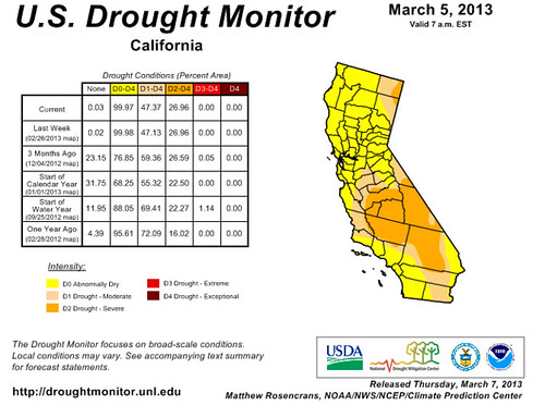
The light yellow shows abnormally dry areas, and the darker yellow shows severe drought. Next, is the latest Drought Monitor for California.
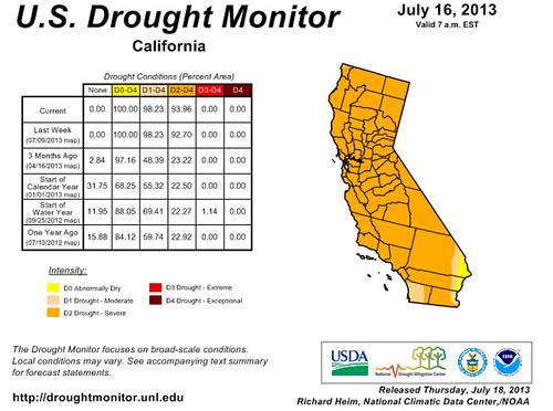
Pretty much the whole state is now in a severe drought.
Forecasts and Results
Here are the details of the forecasts and their results. The dates I used are understood to include a before and after period of a day or so on either side.
March 22 Forecast
Around this date, a stormy and windy system is indicated over southern
California that may bring precipitation.
Results
The Weather Channel reported a winter storm producing rain and high mountain snow from the Northwest to northern and central California.
March 31 Forecast
In and around this date, another storm system is indicated over southern
California.
Results
On the 30th and 31st, rain showers and mountain snows increased for northern and central California, and Great Basin.
April 13-25 Forecast
During this period, Mars transits over the state of California in the Full Moon
chart. This usually coincides with a dry period.
Results
The Weekly Weather and Crop Bulletins for this period said water-supply prospects for California remained bleak. The state experienced warm and dry weather throughout this period.
April 17 Forecast
Specifically around this date, the Sun conjoins Mars and is localized over
California in the Full Moon chart. This corresponds to warmer temperatures and
dry conditions. At times, storms can ensue after the heat.
Results
Posts from the National Weather Service for this date spoke of a warming trend, high pressure, and Santa Ana winds.
April 22 Forecast
At this time one of the above mentioned aspects to Saturn takes places. We
should see a front or low pressure area form off the U.S. West Coast, which may
bring precipitation inland.
Results
The National Weather Service reported an upper level disturbance brought a chance of showers.
April 27 Forecast
At this time Mars triggers the Full Moon chart increasing heat and dryness.
Sometimes this results in storms being generated after the heat.
Results
On the 28th, Accuweather headlines read: Record-Warmth in the Desert Southwest into Early Next Week.
April 28 Forecast
Around this time, the Sun will oppose Saturn off the U.S. West Coast bringing a
front or low pressure system there. The opposition should also affect areas of
southeastern California.
Results
The National Weather Service explained that because of the interaction of an upper level trough and an upper level high pressure system a late season offshore wind event would ensue over southwest California.
May 1 Forecast
A vigorous low pressure area or front forms around now and moves inland bringing
stormy conditions.
Results
On May 2nd, Accuweather reported unusually strong Santa Ana winds and dryness. (The wind is what I expected on the 3rd...but that's close enough)
May 3 Forecast
Warm and dry conditions with the possibility of increased wind velocities are
indicated in and around this date.
Results
An upper level low off the California coast brought a few showers and thunderstorms.
May 5-20 Forecast
In another key chart, Mars will transit across California now bringing warm and
dry conditions.
Results
The Weekly Weather and Crop Bulletins for this period said there were some isolated showers in California between the 5th and 11th. Hot, and mostly dry weather prevailed in California between the 12th and 18th.
May 7-8 Forecast
Mercury's aspect to Mars will bring and warm and dry atmosphere with increased
wind velocities around this time.
Results
An upper-level disturbance triggered scattered showers and thunderstorms some of which produced gusty winds and heavy downpours.
May 11 Forecast
The Sun's conjunction to Mercury is known to bring high pressure, which we
should expect around this date.
Results
The Weather Channel reported very warm conditions in California.
May 12-31 Forecast
The majority of aspects at this time indicate fair weather with not much chance
of rain.
Results
Most of this was covered in the May 5-20 section above. The period from the 20th through the 31st brought worsening drought across the Southwest, warm and dry weather with hot, and breezy conditions.
June 3 Forecast
Due to an aspect involving Saturn, somewhat cooler weather and higher humidity
may be expected but this is not necessarily a rainmaker.
Results
According to the Weekly Weather and Crop Bulletin, a weak upper-level low brought modest cooling to southern California.
June 7-8 Forecast
Mercury makes some important aspects to Uranus and Pluto. This may bring an
anomalous weather pattern to the Pacific Northwest and California. It may mean
stormy or windy conditions or perhaps extremes of cold before and after these
dates.
Results
This forecast was added to and I covered the results
here.
June 12 Forecast
Around this time a cold front lowers temperatures and perhaps triggers a little
precipitation.
Results
The Weekly Weather and Crop Bulletin reported an upper-level low over southern California resulted in mild temperatures over higher terrain.
June 13-20 Forecast
The rest of the season appears to be mostly dry.
Results
The Weekly Weather and Crop Bulletin stated that between June 16-22, little or no rain fell across California. Then from the 23rd to the 29th, early week showers fell in northern California and then turned hot and dry for the latter part of the week.
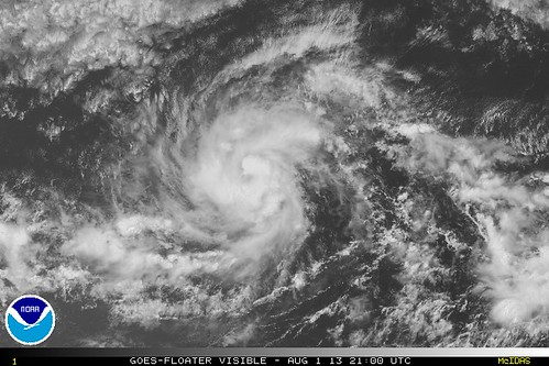
Hurricane Erick Fulfills Long-range Forecast
Hurricane Season 2013 Part 1
West Coast Weather July-August 2013
Tropical Storm Andrea Fulfills Long-range Forecast!
Timing the Relief for Drought-Stricken U.S. Plains
Testing Astrometeorology Part 2
Hurricane Sandy Fulfills Long-range Weather Prediction!
Testing Astrometeorology Part 1
Long-range effects of the May 20, 2012 Solar Eclipse
Long-range effects of the May 20, 2012 Solar Eclipse Part 2
Hurricane Season 2011 Forecast Results
Hurricane Risk-Management
New Weather Alternative Website
Overview of UK Winter 2012-13
The Winters of 2011-14
Fulfilled Long-range Forecasts for Hurricane Season 2010
Introduction to the Weather Alternative
Ten Years of Accelerated Global Warming?