Wednesday, September 30, 2009

Sept 29-Oct 1, 2009 Forecast Results

The Weather Alternative forecast for Sept 29-Oct 1, 2009 stated:

Mercury turns direct on the 29th as it parallels Saturn. A cold front will come pushing out of Canada over the Great Lakes region heading southward over Michigan, Ohio towards the Southeast U.S. triggering storms on its way.

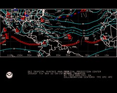
The Weather Channel map for Sept 29th at left shows a strong low pressure system over the Great Lakes kicking up some serious wind, and a cold front that has pushed all the way into the Southeast U.S. and Deep South fulfilling the above mentioned forecast.

Winds in Ohio, Minnesota, Michigan, and New York gusted to over 50 mph. The storm system over the Great Lakes generated hail and downed trees. Windswept rain also added to the miserable weather.

Introduction to the Weather Alternative

How Long-Range Forecasts Are Made

Solar Eclipse Action October and November 2009

A Few More Forecasts for October 2009

Fathering helps self-esteem


A study by the British parenting research project Tomorrow's Men found that fathers who spend a few minutes each day one on one with their sons greatly increase their sons' chances of growing into confident adults.


Of the boys who said that their fathers spent time with them and took an active interest in their progress, more than 90 percent fell in the "can do" category, whereas 72 percent of the boys who said that their fathers rarely or never spent time with them fell into the group with the lowest levels of self-esteem and were also more likely to have emotional and behavioral problems.


More surprisingly, the study found little difference between the positive effects of good father/son relationships in two-parent homes and homes where the father was absent (as in divorce situations) but nevertheless took time with his son. Similar studies have found that in a father's absence, another father figure such as a stepfather, uncle, grandfather, teacher, or mentor, by assuming an active role, can have an equally positive effect.


Monday, September 28, 2009

Sept 23-26, 2009 Forecast Results

According to the long-range weather forecast posted on June 8, 2009, the Mercury-Uranus opposition of Sept 23rd, along with Jupiter's activation of the Feb 6, 2008 solar eclipse, was to trigger possible tropical storm development about 450 miles east of the Windward Islands between Sept 23rd and 26th. This area lies roughly between 52 and 60 west longitude around 17 north latitude.

The National Weather Service map at left for Sept 22nd shows a low pressure system over the forecast area.


On September 24th, the NWS reported:
AN ATLANTIC OCEAN TROPICAL WAVE HAS BEEN MOVED TO 54W/55W TO THE SOUTH OF 19N...MOVING WEST 15 KT... IT IS POSSIBLE THAT STRONG ITCZ PRECIPITATION FROM9N TO 12N BETWEEN 52W AND 55W IS BEING ENHANCED BY THE WAVE.

Accuweather reported on Sept 25th:
Another tropical wave is along 58 west and south of 19 north and is moving west at 10-15 mph. Satellite shows most of the convection with this tropical wave south of 14 north. As it progresses westward, there will be an increase in showers and thunderstorms across the southern Windward Islands, but further development, if any, will be slow to occur.

Introduction to the Weather Alternative
How Long-Range Forecasts Are Made
Solar Eclipse Action October and November 2009
A Few More Forecasts for October 2009

Education


An American woman living in India was having a simple electrical installation done by a native electrician. He troubled her so much for instructions that she at last said irritably, "You know what I want; just use your common sense & do it." The electrician salaamed politely & said, "Madam, common sense is a rare gift of God. I have only a technical education."

Tuesday, September 22, 2009

A Few More Forecasts for October 2009

Here are a few more long-range weather forecasts for October 2009. These forecasts are based on astrometeorology or planetary cycles.
Introduction to the Weather Alternative
How Long-Range Forecasts Are Made


Forecasts
Sept 29-Oct 1, 2009

Mercury turns direct on the 29th as it parallels Saturn. A cold front will come pushing out of Canada over the Great Lakes region heading southward over Michigan, Ohio towards the Southeast U.S. triggering storms on its way.

Oct 3-5, 2009
Stormy conditions are shown for the northern Plains.
A low pressure system, perhaps an Alberta Clipper, affects the Great Lakes area as it moves into the Northeast.
Another low pressure system or front affects the DelMarVa Peninsula.


Oct 10-12, 2009
A storm system pushes through the Plains. The low pressure system may track to the south affecting the area in and around eastern Texas and Oklahoma as it pushes into the Mississippi Valley and Southeast.


Oct 24-26, 2009
Moisture is drawn up over the Plains resulting in storms over the Dakotas and Nebraska.

More October forecasts can be found here:
Solar Eclipse Action October and November 2009
Solar Eclipse Action for August and September 2009

Why Are Governments So Stupid?

Friday, September 18, 2009

Southern Flooding Forecast Results for Sept 11-18, 2009

It's time to look at the results of the September 11-18, 2009 forecast, which was posted on September 1st.

...the Gulf Coast area, roughly from New Orleans to the Florida Peninsula, will be under some very severe weather patterns. This was based on the Saturn-Uranus opposition, among other things. The forecast also stated there may be some tropical storm or hurricane development in the Gulf of Mexico. The strike zone could be from New Orleans to the Florida Panhandle.

During the beginning of the forecast period, conventional meteorologists thought that a low pressure system in the Gulf might develop into some sort of tropical system. Although this never happened lots of moisture from the Gulf has been pumped up over the very forecast area mentioned, and as of today is still being pulled up over the area--thus fulfilling the severe weather prediction for the area from New Orleans to the Florida Peninsula.

A whopping 5.92 inches of rain has soaked Pensacola, Florida, and flash flooding problems have followed torrential rain from Arkansas and Louisiana through Georgia. Multiple high water rescues were preformed in Birmingham, Alabama just to mention some of the recent troubles due to the excessive rain.

The next part of the forecast stated Central America also shows potential for severe weather; possibly a tropical storm or hurricane strike. No hurricanes were reported but on the 11th and 12th the National Weather Service announced that due to a tropical wave AN UPPER LEVEL LOW OVER NICARAGUA... HAS ENHANCED A LARGE CLUSTER OF NUMEROUS STRONG CONVECTION FROM 11N-16N BETWEEN 81W-85W. The map at right shows the low over Central America on the 11th.


The next portion of the forecast was for the Northeast and New England. Here's the forecast: Staring on the 11th, weather conditions are building in intensity and seem to be at their strongest from the 15th through the 18th when storms bringing heavy rainfall are likely. A tropical system cannot be ruled out.


On the 11th, a coastal storm pounded the mid-Atlantic with flooding rain, gusty winds, rough surf, beach erosion and isolated tornadoes. The storm continued on the 12th and because it had tropical characteristics, Accuweather referred to it as The Unnamed Storm. The storm also affected the Northeast and southern New England with flooding rain. This was the main storm during the forecast period although I envisioned more intense storms to take place around the 15th through the 18th.

The last portion of the forecast had to do with Nova Scotia. From the 11th through the 18th, a build up of planetary influence points strongly to a severe weather pattern to affect the area or to the likelihood of a tropical system making landfall around the 17th and 18th.


On the 13th, the aforementioned Unnamed Storm passed by Nova Scotia. The Canadian Weather Service stated A low pressure system south of Nova Scotia will intensify as it tracks northeastward today and tonight. The low is forecast to track across Newfoundland Monday afternoon. Ahead of the low, southeast winds gusting to 100 km/hour...


The 18th (see map at left) brought a low pressure system and front to the area triggering showers.

September 11-18, 2009 Forecast for Eastern U.S. and Nova Scotia
Solar Eclipse Action for August and September 2009
Solar Eclipse Action October and November 2009
Introduction to the Weather Alternative
How Long-Range Forecasts Are Made


Good Science
Good science--good physics, good biology, good chemistry and good economics--depend upon the ability to predict. In other words, if a physicist correctly predicts the moment at which a projectile will strike its target, or a biologist correctly predicts the effect a change in temperature will have on a population of insects, then we can say that these scientists are using good science. On the other hand, if the predictions are wrong, then the science is flawed. --Richard Maybury

Thursday, September 10, 2009

Sept 7-10, 2009 Forecast Results

The Weather Alternative long-range forecast for Sept 7-10 was based on the Solar Eclipse of March 29, 2006. Here's what the forecast called for:

Mars will trigger the solar eclipse of March 29, 2006. The Sun and Moon ascended through Nova Scotia and transit Mars will cut through the Windward Islands at this time. Severe weather, which may be tropical in nature, may afflict these areas now.

As can be seen from the Accuweather map above, the main action was a storm system along the U.S. East Coast. No storm system affected the Nova Scotia area as high pressure held on tight over eastern Canada.

As far as the Windward Islands go, the National Weather Service reported on September 8th that due to the approach of a tropical wave showers would increase in coverage across the Leeward Islands, which are just north of the Windwards.


September 11-18, 2009 Forecast for Eastern U.S. and Nova Scotia
Solar Eclipse Action for August and September 2009
Solar Eclipse Action October and November 2009
Introduction to the Weather Alternative
How Long-Range Forecasts Are Made

Many of life's failures are people who did not realize how close they were to success when they gave up.-- Thomas Edison

Tuesday, September 01, 2009

September 11-18, 2009 Forecast for Eastern U.S. and Nova Scotia

September 11-18, 2009


Forecast for the Southeast
Judging principally from the Solar Ingress chart and the main aspects such as Pluto’s direct station, the Saturn-Uranus opposition, the oppositions of Venus to Jupiter and Neptune, and Mercury’s square to Pluto, the Gulf Coast area, roughly from New Orleans to the Florida Peninsula, will be under some very severe weather patterns.

The crossings between planets in the Solar Ingress and the Lunar Eclipse chart suggest that there may be some tropical storm or hurricane development in the Gulf of Mexico. The strike zone could be from New Orleans to the Florida Panhandle. Central America also shows potential for severe weather; possibly a tropical storm or hurricane strike.

If not an actual tropical system, a severe weather system is possible from the Mississippi Valley eastward to the Southeast and Mid-Atlantic States. Pluto’s station suggests a cold air mass descending out of Canada. The Saturn-Uranus opposition suggests high wind velocities. The Venus oppositions to Jupiter and Neptune suggest warm and moist air masses. Taken together, a clashing of atmospheric elements have the potential to engender very strong storms packing damaging winds, hail, and maybe spawning tornadoes.


Northeast and New England
The New Moon and Full Moon charts place the planet Neptune in key positions over this area. The main aspects at this time are Venus opposition Jupiter and Venus opposition Neptune. These tend to increase warmth and moisture. In extreme cases, Neptune has to do with flooding conditions. Staring on the 11th, weather conditions are building in intensity and seem to be at their strongest from the 15th through the 18th when storms bringing heavy rainfall are likely. A tropical system cannot be ruled out.


Nova Scotia
The Last Quarter Moon places a special emphasis over this area. From the 11th through the 18th, a build up of planetary influence points strongly to a severe weather pattern to affect the area or to the likelihood of a tropical system making landfall around the 17th and 18th.

Solar Eclipse Action for August and September 2009
Solar Eclipse Action October and November 2009
Introduction to the Weather Alternative
How Long-Range Forecasts Are Made

Drinking

Don't try to drown your sorrow in alcohol because sorrow is an expert swimmer.

In ten years 46,000 Americans died in Vietnam. During that same time 250,000 persons were killed in the U.S. by drunk drivers.