The next forecast in The Mountain Astrologer Feb/Mar 2012 issue covered the period between January 19-21. The forecast covered three areas. Let's look at how they turned out. These forecasts were prepared in July 2011.
Forecast
January 19-21, 2012
The sextiles to Uranus and Pluto by the Sun and Venus indicate cold but fair conditions now. The Sun's squares to the approaching Jupiter-Saturn opposition, however, add inclement conditions with above average precipitation. These combine over the U.S. Northeast and New England promising messy winter conditions. A strong low pressure system is also indicated over the western Great Lakes.
Results
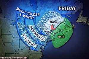
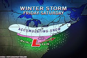
The Accuweather map below shows the winter storm hitting the Great Lakes, Northeast and New England on the 20th and 21st as forecast.
Here are some of the weather headlines for this period.
Jan 19: Snow for Chicago, Detroit, Cleveland, NYC, Boston
Jan 20: Snowstorm for NYC, Hartford, Boston and Others
Jan 21: Snowstorm rips through Northeast
A quick-hitting winter storm brings the heaviest snow since the late October snowstorm to parts of the Northeast.
Forecast
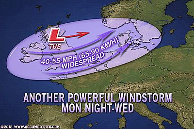
The U.K. gets a blast of winter now, and Portugal is slated for stormy conditions. Farther east over Turkey, the Jupiter-Saturn opposition will most likely result in a winter storm.
Results
Here are some of the European weather headlines. I'm not sure what weather Turkey experienced.
Jan 20: Heavy snow, Gales
Cloudy, wet and windy across England, France, The Low Countries, Denmark and Germany with outbreaks of rain.
Jan 21: Cold and wintry, Strong winds
Forecast
While Uranus and Pluto bring cold air through Russia and central China, the Jupiter-Saturn combination seems to promise a strong winter storm system over China's eastern and southeastern coasts.
Results
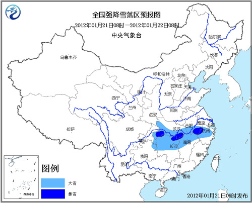
On the 20th and 21st, the China Meteorological Administration issued a blizzard alert close to the areas forecast as shown in the map below.
Forecast
January 19-21, 2012
The sextiles to Uranus and Pluto by the Sun and Venus indicate cold but fair conditions now. The Sun's squares to the approaching Jupiter-Saturn opposition, however, add inclement conditions with above average precipitation. These combine over the U.S. Northeast and New England promising messy winter conditions. A strong low pressure system is also indicated over the western Great Lakes.
Results
The Accuweather map below shows the winter storm hitting the Great Lakes, Northeast and New England on the 20th and 21st as forecast.
Here are some of the weather headlines for this period.
Jan 19: Snow for Chicago, Detroit, Cleveland, NYC, Boston
Jan 20: Snowstorm for NYC, Hartford, Boston and Others
Jan 21: Snowstorm rips through Northeast
A quick-hitting winter storm brings the heaviest snow since the late October snowstorm to parts of the Northeast.
Forecast
The U.K. gets a blast of winter now, and Portugal is slated for stormy conditions. Farther east over Turkey, the Jupiter-Saturn opposition will most likely result in a winter storm.
Results
Here are some of the European weather headlines. I'm not sure what weather Turkey experienced.
Jan 20: Heavy snow, Gales
Cloudy, wet and windy across England, France, The Low Countries, Denmark and Germany with outbreaks of rain.
Jan 21: Cold and wintry, Strong winds
Forecast
While Uranus and Pluto bring cold air through Russia and central China, the Jupiter-Saturn combination seems to promise a strong winter storm system over China's eastern and southeastern coasts.
Results
On the 20th and 21st, the China Meteorological Administration issued a blizzard alert close to the areas forecast as shown in the map below.
The Central Meteorological Office issues Blue alert for blizzard at 6:00 p.m. on January 20 (Beijing Time):
It is forecasted that in the next 24 hours from 8:00 a.m. on January 20 there will be heavy snow affecting southeastern Gansu, central Shaanxi, southwestern Shanxi, most parts of Hubei, southern Anhui, northwestern Jiangxi, and northwestern Hunan. Isolated areas in southern Hubei will be hit by blizzard with precipitation of 10 to 13 mm. Parts of central Guizhou will see freezing rain.
It is forecasted that in the next 24 hours from 8:00 a.m. on January 20 there will be heavy snow affecting southeastern Gansu, central Shaanxi, southwestern Shanxi, most parts of Hubei, southern Anhui, northwestern Jiangxi, and northwestern Hunan. Isolated areas in southern Hubei will be hit by blizzard with precipitation of 10 to 13 mm. Parts of central Guizhou will see freezing rain.
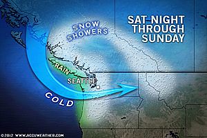
Winter 2011-12 The Rockies
Winter 2011-12 West Coast
Hurricane Season 2011 Forecast Results
Hurricane Risk-Management
Update on Winter 2011-12
Texas Summer 2012
New Weather Alternative Website
Overview of UK Winter 2012-13
The Winters of 2011-14
Fulfilled Long-range Forecasts for Hurricane Season 2010
Introduction to the Weather Alternative