Saturday, November 28, 2009

Thanksgiving 2009 Forecast Results

The Weather Alternative Thanksgiving Forecast 2009 was posted on October 30th. The forecast, based on planetary cycles, achieved a high degree of accuracy. Here are the results.


Forecast

West

Most charts coincide with a storm system moving through the Pacific Northwest into the Intermountain West on the 23rd and 24th. The coastal Pacific Northwest might get some pleasant weather on the 25th, but further inland over the Intermountain West the 26th and 27th looks stormy.


Results

A major storm entered the Pacific Northwest on the 22nd--a day before my forecast. Another weaker system moved in on the 24th bringing rain and some higher-elevation snow to the Pacific Northwest.

I foresaw pleasant weather on the 25th for the coastal Pacific NW. There was a break from the powerhouse storms on the 25h and high pressure over the Great Basin area but some rain and mountain snow still affected the coastal areas. A new front entered the Pacific Northwest on the 26th and moved inland to the Intermountain West on the 26th and 27th.


Forecast

Plains
The 23rd starts with moist air being drawn up over Texas and the southern and eastern Plains initiating storms. Cooler air is drawn southward at this time over the Rockies triggering storms along the Front Range area. Around the 24th, the southern Rockies area centering around New Mexico will have unsettled weather. More cooler Canadian air makes it way southward on the 25th and 26th over the Northern Plains and then meets with moist air creating storms over the Plains.

Results
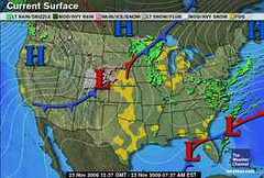
On the 23rd, Accuweathr reported Farther west in the Southern Plains, a developing system will bring showers and thunderstorms to the Plains and Lower Mississippi Valley tonight and tomorrow. The above Weather Channel map for the 23rd also shows a low pressure system over the Front Range area with a cold front headed into New Mexico.

On the 25th, Accuweather reported that cold winds blasted the northern Plains.


Forecast

Mississippi Valley

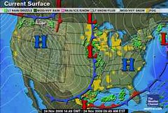
The mid-Mississippi Valley area in and around Missouri shows a low pressure area or front bringing rain around the 24th. By the 25th and 26th this develops into more rainy weather for the Mississippi Valley.


Results

The above Weather Channel map for the 24th shows the predicted low pressure system over Missouri. This low continued to pester the northern Mississippi Valley area on the 25th and brought blustery conditions to the Mississippi Valley and western Great Lakes on the 26th.


Forecast

East
On the 23rd, a front is indicated running the length of the East Coast from Florida through New York generating showers. On the 24th, with more moisture being funneled up over Florida and the Southeast, storms are indicated over the area in and around North Carolina and Virginia. Fair conditions seem to make it into the Southeast, Mid-Atlantic, and Northeast by the 25th and 26th.


Results

Although there was no front running hte length of the East Coast from Florida to New York on the 23rd, the whole forecast area did experience showers on that day. An area of low pressure brought rain as it traveled from the Carolinas to New England. The tail end of a front also brought showers to the Florida Peninsula.

I predicted more rain for Florida and the area in and around North Carolina and Virginia on the 24th. The main rain event over the forecast area didn't happen until the 25th.

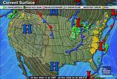
The Weather Channel map above for the 26th, shows the fair conditions making it into the Southeast, Mid-Atlantic, and Northeast. Notice the area is between two fronts.


Forecast

New England

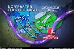
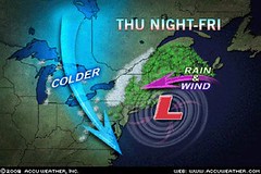
The 26th and 27th are very stormy over the New England area. Indications of severe weather in the lunar eclipse chart of August 5, 2009 will be activated now. The last time these were triggered tropical rainstorm Danny gave a glancing blow to the New England area bringing winds gusting between 40-60 mph and flash flooding due to torrential rainfall that dropped between 2-5 inches of rain. Yikes!

Results

On the 26th a coastal storm over the Carolinas built up and hit New England on the 27th as predicted. I equated this storm to tropical rainstorm Danny since both storms had the same astro-meteorological cause based on the lunar eclipse of Aug 2009. The results were similar. On the 27th, New England had heavy rain and wind gusts of 40 to 50 mph. The storm ushered in cold and the windy conditions created power outages and downed trees.


Introduction to the Weather Alternative

How Long-Range Forecasts Are Made

Christmas and New Year's Weather Forecast United States and Europe

Super Bowl Sunday 2010 Weather Forecast

Saint Patrick's Day 2010 Weather Forecast


Twinkles?
By Gina Bridgeman, Guideposts

One day when my daughter Maria and I were playing on the bed, she suddenly pointed to the fine lines beside my eyes.
"What are these?" she asked.
"Wrinkles," I said. I thought, Oh, great-now my two-year-old has to remind me I'm not getting any younger.
"Twinkles," she said, pleased with herself.
"No, wrin-" I stopped in mid-correction. "You know, that makes them sound like something good, Maria. Twinkles they are."
That night as I looked in the mirror, I realized that my twinkles do come from smiling and laughing, forming a kind of road map of the great joy with which God has blessed my life. From parents who filled our house with laughter and taught us not to take ourselves too seriously, and brothers who are still two of the funniest people I know, I learned the value of a laugh a day. If there's one gift God has given me in abundance, it's joy, and I have the twinkles to prove it.
I'm turning forty, and while I haven't been particularly excited about it, or about those subtle lines or my one pesky gray hair that returns each time I snip it off, I'm ready to look at it all in a new way. Mark Twain wrote, "Wrinkles should merely indicate where smiles have been." So rejoice in the twinkles! They're a sign to the world that God has given me a lot to smile and laugh about.
Joyful Creator, in Your grace continue to fill my life with laughter, joy and an abundance of twinkles.

Tuesday, November 17, 2009

Saint Patrick's Day 2010 Weather Forecast

Here’s the Saint Patrick’s Day 2010 long-range weather forecast for the central and eastern United States and for the United Kingdom.


Central and Eastern United States
March 13-17, 2010

Starting on the 13th, penetratingly cold air descends over the Mississippi Valley and Great Lakes area on gusty winds lowering temperatures and continuing southward easily reaching the central and eastern Gulf Coast States. Here are two ways this may play out:


Scenario 1:
The cold air is due to a high pressure system that dosen’t bring much precipitation with it but barrels down toward the Gulf Coast and also spreads eastward toward the Northeast U.S.
Scenario 2:
As often happens with cold air masses, it interacts with moisture already in place bringing significant precipitation and forms a low pressure system that results in a strong winter storm. The storm system then tracks toward the Northeast U.S.


In both scenarios, we could see lake-effect snows on the southern portions of the Great Lakes.

A chance of rain is indicated for New York City on the 17th for the 248th Saint Patrick’s Day Parade. At the same time the aforementioned weather system (in scenarios 1 and 2) from the central U.S. is moving eastward and due to hit NYC on the evening of the 17th although some models show it hitting earlier.


United Kingdom
March 13-17, 2010

A cold air mass works its way southward and eastward over the United Kingdom. Windy conditions and precipitation are likely.


Introduction to the Weather Alternative

How Long-Range Forecasts Are Made

Thanksgiving 2009 Forecast

Christmas and New Year's Weather Forecast United States and Europe

Super Bowl Sunday 2010 Weather Forecast

Think About it...


While three-fifths of the World's population worries about hunger and survival, we anxiously wrestle with overweight and boredom. Every newspaper supplies increasing evidence that in terms of gross national product, comfort, and personal income, we are superior, yet, in personal relationships and inner peace, we are revealing that we do not know how to live. We are artists at having and failures at being.

Saturday, November 14, 2009

Super Bowl Sunday 2010 Weather Forecast

Super Bowl Sunday will take place on February 7, 2010 at Miami's Dolphin Stadium. This de facto American holiday is the second largest U.S. food consumption day after Thanksgiving.


The city of Miami has often hosted the Super Bowl due to its agreeable February weather. The average daytime temperature in Miami at this time of year is 78 degrees with a nighttime average temperature reading of 61.


Conventional meteorology is extremely limited in its ability to forecast weather conditions beyond 3 or 4 days. Even with the help of the latest supercomputers, which can run about one trillion calculations every second, meteorologists can only expect this upgraded technology to slightly improve the accuracy of their 3-to-4-day forecasts. The idea of forecasting Miami's weather for Feb 7, 2010 on Nov 14, 2009 is not even remotely possible.


The ancient study of astro-meteorology, which considers planetary cycles as indicators of terrestrial weather patterns allows one to look far into the future. Since planetary positions can be known months and years in advance, and since a reliable body of knowledge of each planet's influence on our weather has been compiled and tested over thousands of years, an astro-meteorologist can look ahead and make a pretty accurate forecast. Of course, no forecast method, be it conventional or otherwise, can claim 100% accuracy but astro-meteorology offers the best possibility for long-range predictions as has been shown on this site.


In looking at the planetary line-up over Miami for February 7th, we find a conjunction of the planets Venus and Neptune. These planets when aligned are associated with southerly air flows and an increase in moisture. Under Venus-Neptune rainfall can be heavy, at times leading to flash flooding. The Moon will trigger this pair the day before. So it appears that starting on the 6th into the 7th there is a strong possibility of rain for the Miami area and Florida in general. Hopefully, it won't spoil too much of the fun but if you're headed that way, you might want to be prepared.


Introduction to the Weather Alternative

How Long-Range Forecasts Are Made

Thanksgiving 2009 Forecast

Christmas and New Year's Weather Forecast United States and Europe

Food for Thought

Instant gratification is no longer fast enough.

Adults are just children with better excuses.

Wednesday, November 11, 2009

Tropical Storm Phyan

Tropical Storm Phyan is produced heavy rain over portions of west India Monday and Tuesday. It will make landfall near Mumbai on Wednesday.


What is the astro-meteorological connection? The square aspect between Saturn and Pluto (exact on the 15th, but triggered by the Moon's aspects on the 12th).

The astro-locality map below for the 3rd Quarter Moon of Nov 9th shows a Saturn line passing through the very area. It's the yellow line running north to south through west India.


Introduction to the Weather Alternative

How Long-Range Forecasts Are Made

Thanksgiving 2009 Forecast

Christmas and New Year's Weather Forecast United States and Europe

The Dangers of Genetically Modified Organisims

Saturday, November 07, 2009

Christmas Weather Forecast and New Year's Weather Forecast United States and Europe

The long-range weather forecasts presented here at The Weather Alternative are based on the ancient study of astro-meteorology or planetary cycles.

Here are some forecasts for the Christmas season and New Year's Eve in the United States and Europe.

United States

New England

Forecast
Dec 20, 2009 - Jan 1, 2010
Dec 20-22
: Somebody left the faucet on! Heavy rain is possible for New England as warm moist air is drawn up over the East Coast and New England.
Dec 25-27: Windy and cold weather is in store for the Northeast and New England. If enough moisture is in place, storms ensue.
Jan 1, 2010: Another blast of cold winds out of Canada for the Northeast and New England.

East Coast

Forecast
Dec 20, 2009 - Jan 1, 2010

Dec 20-22: A front moves through to the East Coast. This has the potential to unleash heavy rainfall from the North Carolina coast through the Northeast.
Dec 25-27: Cold and windy over the Northeast.
Dec 31-Jan 1: Another front producing storms through the Mid-Atlantic and Northeast.


Mississippi Valley and East Central U.S.

Forecast
Dec 22, 2009 - Jan 1,
2010
Dec 22-23: A potent storm system begins to gear up over the Mississippi Valley as moisture from the Gulf interacts with cold air out of Canada.
Dec 24-26: A strong winter storm hits the East Central States from Michigan down through the Florida Panhandle. Expect major travel problems and airport delays. Special intensity is shown over the Southeast U.S. in and around Georgia and South Carolina.
Dec 28-31: The area stays stormy as another low pressure system or front pushes through the East Central area leading up to New Year’s Eve.

Rockies

Forecast
Dec 28-31

Warm, moist air filters up over the Rockies from south to north. This may result in foggy conditions but more importantly strong downpours are possible.

West Coast


Forecast
Dec 20-Jan 01
Dec 20-22
: An energetic front enters the U.S. West Coast bringing a good amount of precipitation.
Dec 24: A warm up over the Pacific NW.
Jan 1: A cold front out of British Columbia begins to enter the Pacific Northwest.


Europe


Forecast
Dec 22-23: On the 22nd and 23rd, a cold, dry air mass descends over the United Kingdom and begins to interact with a moist, low pressure area just north of Ireland driving clouds and precipitation over the British Isles.
Dec 24-25: By the 24th and 25th a strong front or storm system is battering France, Germany, and the surrounding areas.
Dec 26: From the 26th on, cold, windy conditions set in over the British Isles, southward into France.
Dec 27-29: A series of fronts or a lingering low pressure area continues to keep the region in and around France and Germany under stormy conditions. Heavy precipitation is shown for the British Isles.


Introduction to the Weather Alternative

How Long-Range Forecasts Are Made

Thanksgiving 2009 Forecast

Action is Everything

If learning about success was all that it took to do great things with your life, then your success would be guaranteed. The bookstores are full of self-help books, each one of them loaded with ideas that you can use to be more successful. The fact is, however, that all the best advice in the world will only help you if you can motivate yourself to take persistent, continuous action in the direction of your goals until you succeed. --Brian Tracy

Wednesday, November 04, 2009

Nor'easter and Oct-Nov 2009 Forecast Results

The Weather Alternative forecast for Nov 5-7 is being fulfilled by the developing Nor'easter over New England. Today's Accuweather article "Cold Winds to Grip Northeast" explains how a storm will intensify as it moves off the New England coast tomorrow, Thursday, and Friday (Nov 5-6). Temps will feel like they're in the teens due to strong northerly winds on the back side of the storm. Some areas of the Northeast will have an early season snowfall.


The Weather Alternative forecast for this time period was posted on June 16, 2009 and stated Mars conjoins the solar eclipse degree over the Northeast U.S. Expect storms through the area. This may also affect the Windward Islands, which may see some tropical activity.

As far as tropical activity affecting the Windward Islands, the National Weather Service today reported that two small low pressure systems are centered north of the Leeward Islands.


Another long-range forecast for October 30-Nov 2, 2009 mentioned to watch for possible tropical storm formation in the western Atlantic around 52 west longitude and 15 north latitude.

On October 29th, the National Weather Service reported a tropical wave along 55 west to the south of 16 north was bringing strong showers and thunderstorms to the area.

On November 2nd, they reported another tropical wave along 55 west.


Another forecast for October 29-Nov 2, 2009 called for a storm system over the U.S. Intermountain West and possible tropical storm activity 540 miles southwest of Cabo San Lucas.

No tropical storm activity was reported, but on October 29th, a storm system hit the Pacific Northwest and British Columbia. Rain hit Washington, Oregon, and Idaho. About 1-3 inches of snow covered the northern Rockies.


Introduction to the Weather Alternative

How Long-Range Forecasts Are Made

Thanksgiving 2009 Forecast


The Future Belongs to the Risk Takers

The future belongs to the risk takers, not the security seekers. Life is perverse in the sense that the more you seek security, the less of it you have. But the more you seek opportunity, the more likely it is that you will achieve the security that you desire. --Brian Tracy