Sunday, July 30, 2006

July 27-30, 2006 Forecast Results

Click here for August 2006 Hurricane and Severe Weather Outlook.

Click here for July 2006 Hurricane and Severe Weather Outlook.

These forecasts were calculated between November 16, 2005 and November 28, 2005.

Forecast:

July 27-30: The inhabitants of the western coast of Mexico around the States of Chihuahua, Michoacan, Jalisco, and Nayarit should prepare for tropical storm development.
It seems the East Coast will be the focal point for severe weather as well. It may be a tropical system affecting the Carolinas and northward. The Upper Mississippi Valley also stands out in regards to strong winds.

Results

The inhabitants of the western coast of Mexico around the States of Chihuahua, Michoacan, Jalisco, and Nayarit should prepare for tropical storm development.

July 27, 2006- Mexican Weather Bureau
Áreas con potencial de tormentas (viento y fenómenos hidrometeorológicos de corta duración):

Intensas: Baja California Sur, Sonora, Sinaloa, Nayartit, Jalisco, Colima, Michoacán, Guerrero, Oaxaca, Chiapas, Tabasco, Hidalgo, Tamaulipas y Veracruz.

Severe thunderstorms over a number of States including Chihuahua, Michoacan, Jalisco, and Nayarit.

July 28, 2006- Mexican Weather Bureau
Lluvias intensas se esperan en Sonora y Chihuahua.

Heavy rain over Sonora and Chihuahua.

It seems the East Coast will be the focal point for severe weather as well. It may be a tropical system affecting the Carolinas and northward.

July 28, 2006- Accuweather
Heavy drenching thunderstorms today will spread across the Ohio Valley and the Northeast.
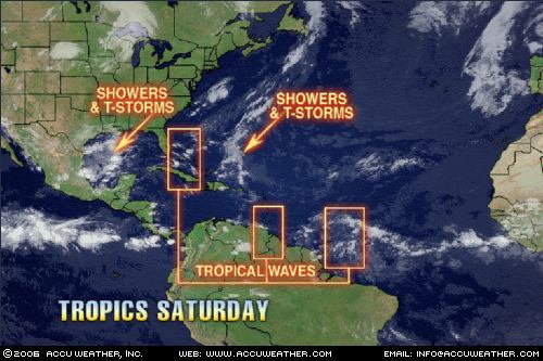
This weekend, a tropical wave will near Florida from the Caribbean. This wave will make for a breezy day along the eastern coastline of Florida, but more noticeable will be the thunderstorms. Thunderstorms that do form will bring more than your typical rainfall to parts of the Southeast as extra moisture will be injected into the storms.

July 30, 2006- The Weather Channel
South

Deep moisture in place, combined with daytime heating, and a weak disturbance in the atmosphere, will produce scattered showers and thunderstorms across parts of the southeast today. The best opportunities to see these showers and thunderstorms will exist across central and southern Mississippi, southern Alabama and Georgia, and the coastal Carolinas and Florida. Here the sea breeze will interact with boundaries left from storms yesterday to produce brief periods of heavy downpours and gusty winds with a few of the thunderstorms.

The Upper Mississippi Valley also stands out in regards to strong winds.

July 28, 2006- Accuweather
On Thursday, numerous thunderstorms ignited in the juicy air mass blanketing the eastern half of the nation. A frontal boundary across the southern Great Lakes enhanced the development of numerous storms with gusty winds, hail and drenching downpours. Strong thunderstorms knocked out power in the Chicagoland area and caused delays at O'Hare and Midway airports.


July 30, 2006- Accuweather


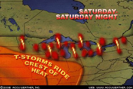
Before the heat spreads over the entire Great Lakes on Monday, the region will have to endure an active weather day, as a frontal boundary has triggered and will continue to trigger severe thunderstorms. As the hot air to the south interacts with the somewhat cooler air to the north, thunderstorms with damaging winds, hail and torrential downpours will erupt.

Sunday, July 23, 2006

August 2006 Hurricane and Severe Weather Outlook

Click here for July 2006 Hurricane and Severe Weather Outlook.

These forecasts were developed during the first two weeks of December 2005.

I’ve included the dates of the Moon’s maximum declination north and south of the equator as well as its equatorial crossing. I’ve noticed that many hurricanes have formed or made landfall around these dates.

Aug. 1-2:
Significant storms focus on the Northeast and New England.

Aug. 6:
Moon attains maximum south declination.

Aug. 6-7:
The coastal areas from Virginia and North Carolina through New England are in for some severe weather in the form of storms producing wind and rain.

Aug. 9-12:
A tropical system may get its act together over Cuba and the Bahamas. Tropical moisture from this system or elsewhere should be pulled up over the Florida Peninsula and the Carolinas. Severe storms will develop over the Ohio Valley as well.
Another hot spot for hurricane development is shown off the eastern coast of Mexico in the western Gulf around 96 West Longitude and 22 North Latitude.

Aug. 12:
Moon crosses equator.

Aug. 11-13:
Gusty winds will prevail along the West Coast with storm potential further inland.

Aug 14-15:
Meteorological mayhem breaks out over the Southeast U.S. through the Ohio Valley as atmospheric elements combine over the area. One scenario shows a tropical system approaching the west coast of Florida and pushing inland with soaking rains. Another model suggests strong storms with damaging winds and flooding.

Aug. 16-18:
A strong storm system is indicated over New England and the Canadian Maritimes as energy moving from the west interacts with a warm, moist air mass.

Aug. 19:
Moon attains maximum north declination.

Aug. 19-22:
Several atmospheric ingredients will come together over the Southeastern States from the Big Bend of Florida into Georgia creating a threat of severe weather. The threat will extend into the Ohio Valley as well. It is possible that this signifies a tropical system or at least abundant tropical moisture that drops heavy rain over the Southeast.

Aug. 20-22:
Another potential Hurricane Hot Spot that also bears watching now extends from the central Gulf of Mexico into the Yucatan Peninsula.

Aug 22-23:
Increasing moisture over the central California coast may lead to anomalous rainfall.
A strong low pressure system develops over the western Great Lakes unleashing strong thunderstorms and gusty winds. (Forecast in italics was added on August 8, 2006)

Aug. 26:
Moon crosses equator.

Aug. 26-27:
The central Gulf of Mexico is still a concern for tropical activity during this period.
The West Coast States and Intermountain area will more than likely experience an influx of moisture setting off storms and flash flooding at this time.
An important area worth watching now is the U.S. Southeast particularly northern Florida through the coastal areas of Georgia and South Carolina. Severe weather, perhaps a tropical system, is possible here.

Aug. 28-30:
Tropical storm formation is possible over the central Baja Peninsula. An outbreak of severe thunderstorms is imminent over the Colorado Front Range and adjacent areas.
Tropical troubles are still brewing over a broad area from western Cuba through western Florida and into Georgia and South Carolina. (See August 26-27)

Aug. 30-Sept. 1:
The West Coast and Intermountain West should feel the effects of a strong monsoonal flow that will unleash heavy rainfall over the area. Abnormal amounts of moisture are shown over the southern California coast.
Another potential Hurricane or severe weather trouble spot forms over Louisiana.
The indications for the Northeast are that windy and stormy conditions will affect the Eastern Seaboard from around Washington DC northward into New England.

Friday, July 21, 2006

July 16-19, 2006 Forecast Results

Click here for July 2006 Hurricane and Severe Weather Outlook.

These forecasts were calculated between November 16, 2005 and November 28, 2005.

July 16-18 Forecast:
The west central coast of Mexico near 106 West Longitude and 21 North Latitude shows the potential for severe weather which may be a tropical storm system.

Results

The low pressure system described below became Tropical Depression 5-E, and the Tropical Storm Daniel. It developed along the longitude I pinpointed but further south around 12 to 15 North Latitude instead of 21.

TROPICAL WEATHER DISCUSSION
NWS TPC/NATIONAL HURRICANE CENTER MIAMI FL
1605 UTC SUN JUL 16 2006

LOW PRESSURE NEAR 12N106W WITHIN IS MOVING W 10-15 KT.
MODEL GUIDANCE CONTINUES TO SUGGEST THAT THIS SYSTEM WILL
GRADUALLY STRENGTHEN OVER THE NEXT 12-36 HRS. STRONG CONVECTION IS NOTED WITHIN 30 NM OF THE CENTER AND WITHIN 45 NM EITHER SIDE OF LINE 12N108W 15N106W. SIMILAR CONVECTION IS SEEN WITHIN 30 NM EITHER SIDE OF LINE 15N102W 16N97W...AND OVER THE GULF OF TEHUANTEPEC WITHIN 45 NM OF 15N94W.


Forecast

July 17-19 Forecast:
The east coast of Mexico also shows potential for tropical storm development. The area in question lies along 98 West and 23 North over the States of Tamaulipas and Veracruz.

Results

July 18, 2006
The following report from the Mexican Weather Bureau states that "a low pressure system in the western Gulf of Mexico along the coasts of Tamaulipas and Veracruz...is bringing moderate to strong rain, lightning, and strong winds to the eastern states."

Canal de baja presión en el Occidente del Golfo de México, frente a las costas de Tamaulipas y Veracruz, se asocia a la onda tropical 16, ambos sistemas favorecerán nublados y lluvia de moderada a muy fuerte con tormentas eléctricas y vientos fuertes en los estados de la vertiente Oriental.

July 19, 2006
The following report from the Mexican Weather Bureau states "tropical wave #17 is bringing strong to intense rains to the States of Chiapas, Tabasco, Veracruz, Oaxaca, and Guerrero
La activa onda tropical N0. 17 ocasionará lluvias de muy fuertes a intensas en los estados de Chiapas, Tabasco, Veracruz, Oaxaca y Guerrero.

July 17-19, 2006 Forecast:

On the U.S. mainland, northern and western Texas may see severe storms or tornadoes.

Results

No severe storms or tornadoes reported. The main event was triple-digit heat.

July 17-19, 2006 Forecast:

Further north, over Minnesota and Wisconsin, dangerous storms and damaging winds will be the attention-getter.

Results

July 18, 2006- Accuweather
For some, there will be good news, as a cold front slicing through the Midwest will break up the heat and humidity - at least temporarily. This front, however, will pack a cruel twist, in that it will bring the potential for severe storms with it from the western and central Great Lakes back into Iowa. Damaging wind gusts will be the main threat to be on alert for; however, some storms will also have the capability of producing hail.

July 19, 2006- The Weather Channel
Midwest

Violent thunderstorms erupted in southern Minnesota Wednesday morning then raced off to the southeast toward northwestern Illinois. Once reaching Illinois the thunderstorms took a right turn and went south through western parts of the state. During the evening the storms turned again, this time to the southwest and took aim on St. Louis. Another round of severe thunderstorms is expected overnight tonight. At highest risk are southeastern Minnesota, northern Iowa, southern Wisconsin and far northern Illinois. Besides the threat of twisters, powerful winds, large hail and locally excessive downpours#up to five inches#are likely.

July 17-19, 2006 Forecast:

This potent weather system then continues toward the east over the Mid-Atlantic region and New England.

Results

July 17, 2006- Accuweather
The oppressive heat in parts of the Northeast will be eased a bit, but at a cost. A cold front coming down from Canada Tuesday will collide with the hot, humid air mass over the region. As this happens, the atmosphere will become unstable, and towering thunderstorm clouds will begin to build. A line of storms will march toward the East Coast during the day, but will likely not reach the big cities until later in the day or at night. The main threat with these storms will be from damaging winds and frequent lightning, but large hail and heavy downpours are also expected.

Sunday, July 16, 2006

July 13-15, 2006 Forecast Results

Click here to see July 2006 Hurricane and Severe Weather Outlook.

These forecasts were perpared during November 2005.

July 13-15 Forecast:The development of a tropical system is likely in the southwestern Caribbean. Tropical moisture is indicated as well over the western portions of Cuba and the Florida Peninsula.

Results

July 13, 2006- NWS

DISORGANIZED CLOUDINESS AND SHOWERS OVER THE EASTERN GULF OF
MEXICO...WESTERN CUBA...AND THE FLORIDA PENINSULA ARE ASSOCIATED WITH A WEAK SURFACE TROUGH OF LOW PRESSURE… MODERATE CONVECTION IS FROM FLORIDA TO W CUBA FROM 22N-28N
BETWEEN 81W-85W MOVING W.

July 15, 2006- NWS

SCATTERED MODERATE/ISOLATED STRONG CONVECTION IS OVER THE SW CARIBBEAN FROM 11N-14N BETWEEN 79W-84W.

Tuesday, July 11, 2006

July 6-10, 2006 Forecast Results

Click here for July 2006 Hurricane and Severe Weather Outlook.

These forecasts were calculated between November 16, 2005 and November 28, 2005.


July 6-9 Forecast:
Tropical storm or hurricane formation is likely now east of the Lesser Antilles.

Results


TROPICAL WEATHER DISCUSSION
NWS TPC/NATIONAL HURRICANE CENTER MIAMI FL
805 PM EDT THU JUL 06 2006

TROPICAL WAVE IS ALONG 42W S OF 13N MOVING W 15-20 KT. BROAD
LOW/MID LEVEL SIGNATURE CURVATURE IS OBSERVED ON SATELLITE
IMAGERY. NO ASSOCIATED DEEP SHOWERS/TSTMS. COMPUTER MODELS
FORECAST THE WAVE TO AFFECT THE LESSER ANTILLES LATE SATURDAY (8th) AND PUERTO RICO PROBABLY ON SUNDAY.

July 8-10 Forecast:
A broad area in the Gulf of Mexico stretching from the tip of the Yucatan through the central Gulf may be the focal point for tropical showers to develop into a more organized system.

Results

TROPICAL WEATHER OUTLOOK
NWS TPC/NATIONAL HURRICANE CENTER MIAMI FL
1130 AM EDT FRI JUL 7 2006

A TROPICAL WAVE IS PRODUCING CLOUDINESS AND THUNDERSTORMS IN THE NORTHWESTERN CARIBBEAN SEA. THIS ACTIVITY HAS INCREASED SINCE YESTERDAY AND IS EXPECTED TO SPREAD OVER YUCATAN TODAY AND SATURDAY. SURFACE PRESSURES REMAIN HIGH AND TROPICAL CYCLONE FORMATION IS NOT EXPECTED.

TROPICAL WEATHER DISCUSSION
NWS TPC/NATIONAL HURRICANE CENTER MIAMI FL
805 PM EDT SUN JUL 09 2006

GULF OF MEXICO...
DEEP LAYERED TROUGH OVER THE E US EXTENDS INTO THE GULF WITH
AXIS EXTENDING SW FROM N FLORIDA TO THE COAST OF MEXICO NEAR
22N97W. ABUNDANT UPPER LEVEL MOISTURE COVERS THE GULF AND MEXICO SOUTH 20N...INCLUDING THE YUCATAN PENINSULA.

Saturday, July 08, 2006

July 4-6, 2006 Forecast Results

Click here for July 2006 Hurricane and Severe Weather Outlook.

These forecasts were calculated between November 16, 2005 and November 28, 2005.

July 4-6 Forecast: The extreme southern portions of Mexico in and around the states of Chiapas and Tabasco are in line for tropical activity.

Results

The Mexican Weather Bureau reported very strong storms over Chiapas and Tabasco with lightning, hail, and 2 to 3 inches of rain.

Forecast
Severe weather potential, which may indicate tropical storm or hurricane formation also exists over the Baja California.

Results

No tropical storm or hurricane formantion was reported over the Baja California. The Mexican Weather Bureau the following on July 5th:

Warm. Clear to partly cloudy. Moderate to strong rain with thunderstorm. Moderate west and northwest wind.

Forecast
In the Atlantic, the area east of the Lesser Antilles around 58 West Longitude and 16 North Latitude is a vulnerable area for hurricane formation.

Results

TROPICAL WEATHER DISCUSSION NWS TPC/NATIONAL HURRICANE CENTER MIAMI FL805 PM EDT THU JUL 06 2006

TROPICAL WAVE IS ALONG 58W/59W S OF 12N MOVING W 15-20 KT. WEAK MID LEVEL SIGNATURE CURVATURE IS OBSERVED ON SATELLITE IMAGERY. A CLUSTER OF MODERATE/ISOLATED STRONG CONVECTION IS ALONG GUYANA/VENEZUELA BORDER PROBABLY ASSOCIATED WITH THE WAVE.

Forecast
Windy and stormy action will center over the western Great Lakes area, and then move eastward over the Mid-Atlantic region. A low pressure area over New England will lead to storms that may reach severe limits as it pushes toward the Canadian Maritimes.

Results

NATURE PROVIDES ITS OWN FIREWORKS ACROSS THE MID-ATLANTIC
Posted: Tuesday, July 04, 2006 at 9:09 PM EDT

There will be some thunderstorms across the Mid-Atlantic this evening, some of which will be strong to severe…Storms will have the risk this afternoon and this evening of being severe, mainly from eastern Illinois into New England.

AREA FORECAST DISCUSSION
NATIONAL WEATHER SERVICE CARIBOU ME
1110 PM EDT TUE JUL 4 2006

.SYNOPSIS...LOW PRESSURE MOVING ACROSS SOUTHERN QUEBEC WILL TRACK INTO THE SAINT LAWRENCE VALLEY TONIGHT AND THEN LIFT NORTHEASTTOWARD LABRADOR ON WEDNESDAY. THE LOW WILL REMAIN IN EASTERN CANADA THROUGH THURSDAY.

July 6, 2006- The Weather Channel
Wednesday, a slow-moving cold front brought another deluge to the mid-Atlantic region. The steady downpours led to Flash Flood Warnings around the Washington, D.C., area. Already saturated after last week's heavy rain and flooding, the soil was unable to absorb Wednesday's rain. The combination of the heavy rain and strong wind uprooted trees from Long Island to Virginia.

Forecast
An active weather period continues throughout the West U.S. with severe weather likely over Oregon, Nevada, Utah, and Idaho.

Results

URGENT - IMMEDIATE BROADCAST REQUESTED
FLOOD WATCH
NATIONAL WEATHER SERVICE POCATELLO ID
758 PM MDT TUE JUL 4 2006

...FLASH FLOODING POSSIBLE WEDNESDAY AFTERNOON THROUGH WEDNESDAY NIGHT...


URGENT - WEATHER MESSAGE
NATIONAL WEATHER SERVICE SALT LAKE CITY UT
632 PM MDT TUE JUL 4 2006

...STRONG EAST WINDS THROUGH 8 PM ACROSS EASTERN BOX ELDER COUNTY...

URGENT - WEATHER MESSAGE
NATIONAL WEATHER SERVICE PENDLETON OR
623 PM PDT THU JUL 6 2006

..WIND ADVISORY IN EFFECT UNTIL 11 PM PDT THIS EVENING...

July 6, 2006- The Weather Channel

West
The summer monsoon is in full swing across the Interior West and that means plenty of thunderstorms. Much of the action will be centered across parts of Utah, Colorado, New Mexico and Arizona again. Slow-moving thunderstorms are prone to cause localized flash flooding. Lightning strikes will remain a major fire threat, but localized downpours will bring beneficial rain to some areas.

Thursday, July 06, 2006

July 3-5, 2006 Forecast Results

Click here for July 2006 Hurricane and Severe Weather Outlook.

July 3-5 Forecast: Conditions will be favorable now for tropical storm or hurricane formation over the eastern Pacific around 120 West Longitude and 17 North Latitude. Thunderstorms will roam the western U.S. into the Rockies.

Results


TROPICAL WEATHER DISCUSSION
NWS TPC/NATIONAL HURRICANE CENTER MIAMI FL
0405 UTC MON JUL 03 2006

TROPICAL WAVE ALONG 117W FROM 5N TO 15N IS MOVING W 12-15 KT.
THE LAST VISIBLE AND ENHANCED INFRARED IMAGERY SHOWS A WELL
DEFINED LOW LEVEL CIRCULATION NEAR 12.5N117W WITH SCATTERED
MODERATE TO STRONG CONVECTION SHEARED OFF TO THE SW OF THE LOW LEVEL CENTER AND CONFINED TO WITHIN 180 NM IN THE SW QUADRANT OF THIS LOW LEVEL CENTER. THIS SYSTEM IS CURRENTLY EXPERIENCING NORTHERLY SHEAR WHICH IS INHIBITING ANY EVELOPMENT AT THIS TIME.

Forecast

Thunderstorms will roam the western U.S. into the Rockies.

Results

8:04 p.m. ET 7/4/2006Senior Meteorologist, The Weather Channel

West
Most of the Mountain West will be polka-dotted with showers and thunderstorms again tomorrow--mainly during the afternoon and evening

Sunday, July 02, 2006

Comments on Forecast for July 2-4, 2006


Click here for July 2006 Hurricane and Severe Weather Outlook.

Here is some commentary on the July 2-4, 2006 forecast. This forecast was prepared between Nov. 16-28, 2005.

July 2-4Forecast: The tropics may begin to rumble as planetary indicators off the coast of Veracruz, Mexico suggest the possibility of tropical storm formation there.The Arklatex region shows signs of severe weather as moisture from the Gulf of Mexico is pumped into the area.

Results
The July 1, 2006 Accuweather Map above shows the development of thunderstorms and showers off the coast of Veracruz, Mexico. The Mexican Weather Bureau reported the following today:

Amplia zona de inestabilidad convectiva frente a las costas de Veracruz y Tamaulipas se asocia con nublados de convección moderada a fuerte, favoreciendo nublados con chubascos, tormentas y vientos fuertes. El sistema avanza hacia el Noroeste y se encuentra en vigilancia debido a su lenta evolución. (A wide area of convective instability off the coasts of Veracruz and Tamaulipas is asscociated with moderate to strong convection favoring showers, storms, and strong winds. The system is moving toward the Northeast and is being watched for further development.) (Rough translation is mine)

Forecast continues...
The Arklatex region shows signs of severe weather as moisture from the Gulf of Mexico is pumped into the area.


The map to the left (courtesy of Accuweather) shows the tropical moisture being pulled up over Texas and Louisiana.

Here Comes The Rain AgainSunday, July 02, 2006 2:18 PM EDT More News The Texas Gulf Coast, which had torrential rain for a couple of days nearly 2 weeks ago, is in for another bout of heavy, flooding rain over the next couple of days. A tropical low pressure system, which was in the southern Gulf of Mexico a couple of days ago, has been drawn northward. Tropical moisture has been concentrating around this system and, as it continues to be pushed northward, this tropical moisture will be shoved ashore into coastal Texas, resulting in heavy, drenching thunderstorms. The overall movement of this system will be slow, so parts of coastal Texas appear to be in for another thorough soaking. This story by AccuWeather.com Meteorologist Gerald Mohler.

Louisiana and Arkansas are in for some wet weather due to this system and other factors.

1213 PM CDT SUN JUL 2 2006
THIS HAZARDOUS WEATHER OUTLOOK IS FOR SOUTHEAST OKLAHOMA...NORTHEASTTEXAS...SOUTHWEST ARKANSAS...NORTHWEST...AND NORTH CENTRAL LOUISIANA.

HEAVY RAINFALL PRODUCING THUNDERSTORMS WILL BE POSSIBLE SOUTHWEST OFA TYLER TEXAS TO POLLOCK LOUISIANA LINE THROUGH TONIGHT. BECAUSE OF THE ANTICIPATED SLOW MOVEMENT OF THE SHOWERS AND THUNDERSTORMS...LOCALIZED HEAVY DOWNPOURS IN THE STRONGER STORMSMAY RESULT IN THE PONDING OF WATER OVER PARTS OF EAST TEXAS THROUGHCENTRAL LOUISIANA.

157 PM CDT SUN JUL 2 2006
THIS HAZARDOUS WEATHER OUTLOOK IS FOR A LARGE PART OF ARKANSAS..

AN ACTIVE WEATHER PATTERN IS SETTING UP FOR MUCH OF THE UPCOMING WEEK... AN UPPER LEVEL LOWPRESSURE SYSTEM OVER TEXAS WILL SEND UP COPIOUS AMOUNTS OFMOISTURE OVER THE MID SOUTH DURING MUCH OF THE WEEK... THE LARGE AMOUNT OF MOISTURE OVER THE AREA WILL INTERACT WITHDAYTIME HEATING AND THE FRONTAL BOUNDARY. THIS WILL ALLOW SCATTEREDTO NUMEROUS SHOWERS AND THUNDERSTORMS TO DEVELOP THROUGH WEDNESDAY.SOME OF THE STORMS MAY PRODUCE HEAVY RAINFALL. ...THE STORMS WILL HAVE THECAPABILITY OF PRODUCING ONE TO TWO INCHES OF RAIN IN A VERY SHORT PERIOD OF TIME.