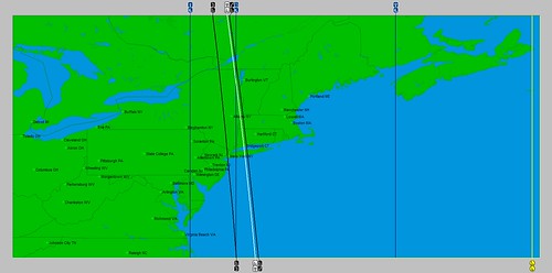
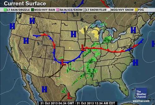
Wednesday, November 27, 2013

New Year's Day Weather 2014

new-years-day-2013-5


A potent winter storm gearing up around the 29th of December will afflict the Northeast U.S., New England, and Nova Scotia through January 2nd of the New Year. Long-range forecast models provide strong indications of a low pressure system to form or at least pass near the Virginia coast and buffet the northeastern sector of the country with strong winds, precipitation, and hazardous weather conditions as it treks toward the Canadian Maritimes.

This long-range forecast is based on the relationship observed between planetary phenomena and atmospheric changes as expounded upon by Johannes Kepler, the discoverer of the planetary laws of motion. A fully documented record of his work from 1602 to 1629 appears in Kepler’s “Mysterium Cosmographicum.”

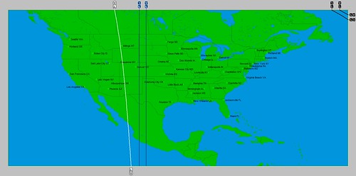
Planetary alignments involving the Sun, Mercury, Mars, Uranus, and Pluto culminate at this time. The above forecast is based on observations of previous weather patterns that coincided with these same alignments. In addition, the New Moon of January 1st will be a perigee-syzygy, commonly referred to as a SuperMoon. This describes a New or Full Moon that takes place when the Moon is at its closest approach to Earth. This particular SuperMoon has the extra influence of the Moon also being at its southernmost declination indicating storms of a more intense nature.

Stay safe and check in with your local weather news source to keep abreast of conditions in your area at this time.

Monday, November 25, 2013

Christmas Day Weather 2013

Christ-in-Christmas1


A boisterous weather system will affect the Northeast U.S. and New England on Christmas Day this year. The storm system will carry potentially damaging winds as an energetic low pressure area or strong front treks through the region.

This long-range forecast is based on the relationship observed between planetary phenomena and atmospheric changes as expounded upon by Johannes Kepler, the discoverer of the planetary laws of motion. A fully documented record of his work from 1602 to 1629 appears in Kepler’s “Mysterium Cosmographicum.”

In regards to Christmas Day, the celestial alignments taking place at this time include the opposition of the planets Mars and Uranus as well as Mars’ activation of the July 1, 2011 Solar Eclipse. As seen in the astro-locality map below, a number of planetary influences (represented by the white, blue, and black lines on the map) congregate over the U.S. Northeast.

Chirstmas


The last opposition between Mars and Uranus occurred on July 18, 2012. This particular opposition also affected the same northeastern section of the country. Accuweather reported on this date that “vicious storms” affected Boston, NYC, Philly, and DC. They warned of “beastly storms” packing “damaging blasts of wind.” Hail, lightning, and blinding downpours also accompanied the storms.


Wednesday, November 20, 2013

An Observation on Typhoon Haiyan


On November 8th, Typhoon Haiyan slammed into the Philippines killing over 10,000 people. Here, over the years on the pages of the Weather Alternative, I’ve made numerous accurate long-range forecasts naming the dates and places of hurricane formations and landfalls months in advance. The links below provide the specifics. My work is based on the work of Johannes Kepler, who was convinced of the truth that the alignments of the planets in our solar system affect weather patterns here on Earth.

philippines-typhoon-haiyan_jpeg-620x412

As I reviewed the different planetary alignments at the time of Typhoon Haiyan’s landfall over the Philippines, I came across an interesting “key” that I think will be instrumental in future forecasts. That key has to do with our closest satellite, the Moon. In astro-meteorology, the Moon has long been known as an important timing factor in long-range weather forecasting, the distributor of moisture, and the celestial trigger that activates other planetary alignments. The Moon, as a weather forecasting tool, has been expertly explored by long-range weather forecaster Ken Ring of www.predictweather.com

Besides orbiting the Earth every 27.32 days, the Moon also varies in its closeness to Earth. Its closest approach to Earth is called perigee, and its farthest distance from the Earth is termed apogee. This aspect of the Moon’s orbit is referred to as the anomalistic month, which is 27.55 days in length. The Moon also moves north and south of the equator in its orbit at the same time. At some point in the month, the Moon will reach its highest north declination and then begin to head south. After it reaches its southern most declination it begins to head north again and repeat the cycle.

Each one of these cycles is important in long-range weather forecasting. At times, these cycles can overlap each other for a while, and when they do, the lunar influence is even stronger than usual. This is exactly what was happening during Typhoon Haiyan’s landfall over the Philippines. Around November 7th, the Moon was at its closest approach to Earth (perigee) and at its southernmost declination. In addition to this, the Moon was making a square to Uranus and an opposition to Pluto. These two outer planets and been in exact square to each other on November 1st so they were still very close. The square between these two planets, according to astro-meteorology is very disruptive to atmospheric conditions. The chart below shows that at the time the Moon made its square to Uranus all three celestial bodies were over the Philippines.  
Haiyan


Let’s follow this pattern because it repeats itself during the month of December. The Moon will be at its southernmost declination and at its closest approach to Earth again as it squares Uranus and conjoins Pluto on December 4th. Now, Uranus and Pluto will not be as close to each other as they were in November, but I think we should see some type of severe weather system generated by this. The first astro-locality map below shows that India will be affect. This is the post-monsoon season in India, so, since Uranus-Pluto can signify cold air masses, there might be an outbreak of cold air from the north.
India
The next map shows that this trio will also affect the Rocky Mountains of the United States. This could result in a strong cold front and perhaps precipitation and windy conditions.
USA


The last map shows the Moon, Uranus, and Pluto over the waters just north of the Guyanas of South America. We are no longer in hurricane season at this time but perhaps some type of low pressure area will form.  
South America

Hurricane Erick Fulfills Long-range Forecast
Tropical Storm Andrea Fulfills Long-range Forecast!
Timing the Relief for Drought-Stricken U.S. Plains
Testing Astrometeorology Part 2
Hurricane Sandy Fulfills Long-range Weather Prediction!
Testing Astrometeorology Part 1
Long-range effects of the May 20, 2012 Solar Eclipse
Long-range effects of the May 20, 2012 Solar Eclipse Part 2
Hurricane Season 2011 Forecast Results
Hurricane Risk-Management
New Weather Alternative Website
Overview of UK Winter 2012-13
The Winters of 2011-14
Fulfilled Long-range Forecasts for Hurricane Season 2010
Introduction to the Weather Alternative

Obamacare Fix
140352_600

Sunday, November 03, 2013

Dangerous Weather Pattern Results

The October 1, 2013 post Dangerous Weather Pattern October 30-November 3, 2013 warning of a severe weather pattern to affect the Plains and Mississippi Valley materialized on schedule fulfilling the long-range forecast issued thirty days in advance.

Here are some of the details:

Forecast
The forecast related that the storm system would likely start over the West Coast states, transfer its energy eastward, and crank up over the Plains.

Results
The Weather Channel reported on Tuesday, October 29th that "The cold front from the Rockies winter storm charges eastward Wednesday (30th) increasing the threat of severe thunderstorms in western and central Oklahoma and central Texas."

Forecast
The forecast then mentioned that serious activity starts around October 30th when a major storm system would affect the Central Plains with severe weather warnings as far south as Texas. The severe weather system would then continue through the Mississippi Valley.

Results
Accuweather reported that on Wednesday, October 30th, "Thunderstorms produced wind gusts over 60 mph in southwestern Oklahoma Wednesday night and extreme downpours caused flash flooding across central Texas into the early morning hours Thursday." Below is the Weather Channel map for October 30th.

Oct 30

According to the Weather Channel, 1 to 3 inches of rain was expected from Missouri to Michigan with isolated amounts of 4 to 5 inches in some areas. Sustained winds of 15 to 35 mph with gusts up to 50 mph were expected over the Great Lakes. The lower Mississippi Valley was also under a severe weather threat best shown by the following Accuweather map for October 31st.
31 Halloween

Shortly I will post some long-range weather forecasts for the U.S. Northeast winter.

Hurricane Erick Fulfills Long-range Forecast
Tropical Storm Andrea Fulfills Long-range Forecast!
Timing the Relief for Drought-Stricken U.S. Plains
Testing Astrometeorology Part 2
Hurricane Sandy Fulfills Long-range Weather Prediction!
Testing Astrometeorology Part 1
Long-range effects of the May 20, 2012 Solar Eclipse
Long-range effects of the May 20, 2012 Solar Eclipse Part 2
Hurricane Season 2011 Forecast Results
Hurricane Risk-Management
New Weather Alternative Website
Overview of UK Winter 2012-13
The Winters of 2011-14
Fulfilled Long-range Forecasts for Hurricane Season 2010
Introduction to the Weather Alternative