Click here for the
Introduction to The Weather AlternativeRead about a possible
January Blizzard
My
December 15, 2006 post contained a long-range forecast for January 15-17, 2007. The forecast pinpointed the West Coast States for
intense cold fronts, precipitation, and high wind velocities. Here's a recap of what happened.
Intense cold fronts...
Jan 16- Accuweather
...the cold has been a catastrophe for California's citrus industry. Widespread subfreezing temperatures may have damaged up to three-quarters of the state's billion-dollar citrus crop. A.G. Kawamura, secretary of the California Department of Food and Agriculture, tells Associated Press, "This is one of those freezes that, unfortunately, we'll all remember."
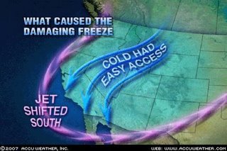 In days prior, arctic air sitting over Montana and western Canada produced temperatures well below zero. At the time, the cold had no reason to come south. Then the jet stream shifted. When that happened, nothing held back the cold, and arctic air had full access to the lower half of California and southern Nevada. That combined with crystal clear nights allowed the temperature to plummet, resulting in a widespread killer freeze. The total extent of the damage is not known, but it is estimated that 75 percent of the citrus crop is in ruin.
Precipitation...
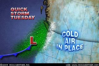
Jan 15th- Accuweather
A quick-moving storm will move into the Northwest from tonight into Tuesday (16th). Precipitation, mainly in the form of rain, will push onto the Washington coastline late tonight. However, the rain will turn to snow as it runs into the colder air in place to the east. The cities along the I-5 Corridor are forecast to receive some snow from this storm.
Jan 18th-
Blizzard closes I-5 north of Los Angeles
A fast-moving cold storm dropped snow in the mountains above Malibu, left white coats of hail in the city and unleashed a blizzard Wednesday that closed Interstate 5 north of Los Angeles.

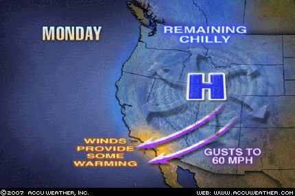
High velocity winds...

Jan 15th- Accuweather
Gusty winds will blow through the mountain passes and canyons of Southern California today and into the first part of Tuesday. With an area of high pressure strengthening over the Rockies, the resultant offshore flow will cause winds to gust to 60 mph in the usual windy locations.