Friday, October 27, 2006

Drenching Rains in India


Click here for the Introduction to The Weather Alternative

Click here for October 2006 Hurricane and Severe Weather Outlook

Drenching rains along India's east coast confirm The Weather Alternative's long-range forecast for October 22-25. This forecast was prepared in January 2006 and published in the July 2006 edition of Dell Horoscope. The forecast was a follows:

Oct. 22-25:
The potential for major tropical activity is also shown for the eastern coast of India.

Yesterday Accuweather reported:

International Weather News Center World Weather Summary
Posted: 26-OCT-2006 11:24am EDT


Downpours drenched the eastern shores of southern India Wednesday to Thursday. Among observation sites, Chennai (Madras) was wettest with 5.63 inches of rain within 24 hours ending Thursday morning, local time; this is more than half of the average rainfall for all of October.

Thursday, October 26, 2006

Colorado Blizzard

Click here for October 2006 Hurricane and Severe Weather Outlook

Click here for the Introduction to The Weather Alternative

The Weather Alternative Forecast for Oct 25-27 posted at the end of September is certainly shaping up.


Oct 25-27:
A vigorous low pressure system will trek across the Rockies generating strong storms.


Here's what Accuweather has to say:

Snowstorm Impact
Updated: Wednesday, October 25, 2006 3:01 PM
This will be remembered as a big storm. The heaviest snow will fall in the Colorado Rockies and along the Front Range. Snowfall totals will exceed a foot in the south-central part of the state. In Denver, AccuWeather.com expects up to 8 inches. Storm development will be explosive later Wednesday night as air masses clash. The intensifying swirl of air will cause winds to reach 40 miles or more resulting in blowing snow and blizzard conditions. The only thing missing will be extremely low temperatures, which is a trait of a true blizzard. The storm will close roads, cause airport delays and bring down power lines. The snow from this storm will not expand across the Great Plains due to a lack of cold air. There it will just rain.

Monday, October 23, 2006

Coast to Coast

Click here for October 2006 Hurricane and Severe Weather Outlook

Click here for the Introduction to The Weather Alternative

A number of forecasts were posted at the end of September for October 22-25. Here's a run down on their accuracy.

Forecasts Posted at the end of September

Oct. 22-25:

A new wave of inclement weather reaches the West Coast States. The period climaxes with the potential for tempestuous, widespread storms and heavy downfall.

The Plains should respond with an outbreak of severe weather, which may include possible tropical storm implications along the southwest coast of Texas.

The potential for major tropical activity is also shown for the eastern coast of India.

The eastern U.S. should be dealing with its own weather anomalies as temperatures skyrocket. The atmosphere may try and equalize the situation by unleashing strong storms over the Southeast and Mid-Atlantic regions. A tropical system cannot be ruled out.

Another Hurricane Hot Spot may develop off the eastern coast of Nicaragua threatening Central America, while the island of Jamaica is in for severe weather as well.


West Coast

The Weather Channel today reports " Two separate systems will hurl showers into the West tomorrow; one into the Pacific Northwest, the other into the Southwest." That looks good for my forecast above.

Plains


Accuweather is forecasting a storm for the Plains starting on Wed. Oct 24th, which would fall within dates for my forecast.


The next Accuweather graphic is interesting since my forecast calls for "possible tropical storm implications along the southwest coast of Texas."


Accuweather says "Moisture from Hurricane Paul will come up into Mexico, then turn eastward into Texas this week. This, combined with a storm taking shape across the central states, could mean another heavy rain event for southeastern Texas and Louisiana..."


India

Nothing reported as of yet.

Eastern U.S.

Yesterday Accuweather reported that "Rain is moving eastward today across the Great Lakes as a storm system over Lower Michigan this morning heads northeastward into southern Ontario. This system will spread rain eastward by this evening into western New England, upstate New York, western Pennsylvania and West Virginia."

Central America

No tropical trouble has been reported over Central America.

Today the National Weather Service reported "WIDELY SCATTERED TSTMS HAVE POPPED UP ALONG COASTAL AREAS FROM GUATEMALA TO NRN COSTA RICA..."

Wednesday, October 18, 2006

New Western Storm and Eastern Rain

Click here for October 2006 Hurricane and Severe Weather Outlook

Click here for the Introduction to The Weather Alternative


The Weather Alternative long-range forecast for October 19-21 called for Showers and storms hit the Northeast down through Virginia, the coastal areas of Florida, Georgia, and South Carolina with falling temperatures and a new round of storms for the West Coast.

Here's the latest from Accuweather:


By Friday (20th), the cold front will reach the East Coast as chilly air continues to spread in from the west. The front and an area of low pressure along it will bring rain from New England southward along the mid-Atlantic coast, while thunderstorms will rumble across the eastern Carolinas.


Wet weather will break out across the Northwest over the next couple of days as a storm arrives from the Pacific. A moist and mild flow into Washington and Oregon will mean snow levels in the Cascades will stay rather high; mainly above pass level.

Sunday, October 15, 2006

Rockies Storm and Texas Trouble

Click here for October 2006 Hurricane and Severe Weather Outlook

Click here for the Introduction to The Weather Alternative

Forecasters are just now becoming aware of the storm potential developing over the Rockies and Plains. The Weather Alternative forecast (see below), crafted last December and January and published in the July issue of Dell Horoscope, pinpointed the developing weather systems months ago.

Oct 15-18, 2006
Abundant moisture is also drawn up over the Plains creating severe weather potential along the Front Range of the Rockies.

Accuweather reports the following:


Another system - an upper-level low, will move across Arizona today spreading plenty of moisture northeastward into New Mexico and the western half of Texas. This will lead to thunderstorms as well across this area. Given
the proximity of the upper-level low and its associated cold pool of air aloft, stronger thunderstorms in this area will have the risk for hail in them.


The Next Cold Shot
One nice thing about fall is it is a season in
transition. If you don't like the weather at one point, give it time, and it will change. That will happen the middle of this week across the northern Rockies and much of the Midwest as the next shot of cold air is released. This air mass will not be quite as cold as its predecessor, but will still be cold enough to drop temperatures back downwards significantly and also set the stage for another winter storm from Montana to the Colorado Rockies and into the Dakotas and western Nebraska, come Tuesday (17th) and Wednesday (18th).

Friday, October 13, 2006

Coming Changes for East and West Coasts

Click here for October 2006 Hurricane and Severe Weather Outlook

Click here for the Introduction to The Weather Alternative

The weather patterns contained in forecasts prepared back in December 2005 and posted here in September 2006 are beginning to become evident to conventional meteorologist. These call for good sized storms over the Mid-Atlantic region and a moisture-laden air mass over California. (See forecast below)
The wet weather in California starting today is a bit earlier than I predicted. The approaching storms over the Mid-Atlantic will arrive as forecast.

Forecast

Oct. 15-18:
The general weather pattern over California begins to change now as a warmer more moisture-laden air mass enters the region. This may result in tropical moisture being funneled into the area setting off heavy showers. Fog may also be a concern now.
The Mid-Atlantic States will have to deal with what promises to be some good-sized storms of their own.

From Accuweather:
A storm system sitting just off the Southern California coastline will slide inland today, bringing showers and thunderstorms that have been dry for much of the summer. Today, locations such as Los Angeles and San Diego will be rather cloudy with showers and thunderstorms in the area. While heavy rain is unlikely, the recent forest fires have left mountainsides exposed, and it will not take too much rain before mudslides will form. This storm system will continue to track inland, bringing rain into the Desert Southwest over the weekend.

While the Eastern Seaboard is dealing with chilly temperatures this Friday the 13th, wet weather is on the horizon. After mainly dry conditions persist through the weekend, a storm system currently moving into Southern California looks to overspread the mid-Atlantic states and Southeast with rain and thunderstorms next Tuesday(17th). Before arriving over these areas, moisture interacting with the system will allow the wet weather to first pour down on the South Central states on Sunday, then over the southern Mississippi and Tennessee valleys on Monday. With the rich moisture streaming overhead, be advised that some of the rain could fall heavily each of these days.

Monday, October 09, 2006

Stormy West and Rockies

Click here for October 2006 Hurricane and Severe Weather Outlook

Click here for the Introduction to The Weather Alternative

Scroll down to see more long-range forecast results

Here's another long-range forecast issued by The Weather Alternative at the end of September that's shaping up:

Oct 8-10:
A storm system moves in over the West Coast States and pushes toward the Rockies.


The Weather Channel reports today that:

Two disturbances will bring wet weather to a large part of the West on Monday. An upper low over western Arizona will pump moisture into the Four Corners region and across the Rocky Mountains.
As a result, look for showers and thunderstorms across Arizona, New Mexico, Utah, and Colorado.
Flood watches are in effect for portions of Utah and Colorado as some of the rain could be locally heavy.

Farther north, another disturbance will trigger snow across the Northern Rockies. Snow advisories and winter storm warnings are in effect for parts of Montana and Wyoming, and some mountain locations could see a foot of snow.

Weather graphic courtesy of Accuweather

Saturday, October 07, 2006

Coming Cold Wave

Click here for October 2006 Hurricane and Severe Weather Outlook

Click here for the Introduction to The Weather Alternative

Conventional meteorologists over the last few days have been warning us of a very powerful cold front that will push southward over the Plains and move toward the east. Here's the latest from Accuweather:
...a blast of cold air...will reach the Plains Wednesday (11th) of next week. A sharp cold front from northern Canada will bring temperatures 15 to 25 degrees below normal, and combined with a strong wind, a drastic change will be on the horizon. Showers and thunderstorms ahead of this cold front will pass through the Plains and into the east. Some locations will receive their first snow of the season behind this cold front as rain will change to snow across the northern Plains, northern Great Lakes, as well as the northern Rockies.
This cold blast will reach southward into the southern Plains and push eastward toward the Atlantic coastline.


This will be a direct fulfillment of The Weather Alternative's October 10-12, 2006 forecast posted at the end of September, which read:

Storms should rev up over the Plains and West Coast. After the 12th, falling temperatures and windy conditions are in store for the eastern U.S.

Wednesday, October 04, 2006

Coastal Storm Approaches

Click here for October 2006 Hurricane and Severe Weather Outlook

Click here for the Introduction to The Weather Alternative

The Weather Alternative forecast for October 5-7, 2006 was prepared in December 2005 and stated "Storms hit from coastal North Carolina and Virginia through the Northeast."

Today Accuweather confirms this long-range forecast.

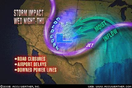
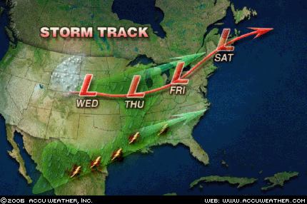
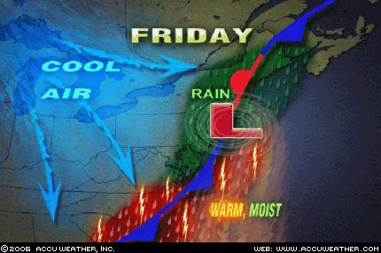
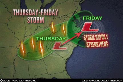
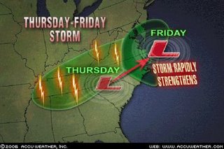
Following summer's brief return, a coastal storm will batter the central Atlantic states as the workweek draws to a close. After causing showers and thunderstorms to rumble across the Northeast, a cold front will drop into the Tennessee Valley on Thursday (5th). Instead of making a quick passage through the region, an area of low pressure will slow down the front's southward progress. To complicate matters, a strong upper-level storm system will also dive into the region, allowing the low pressure to rapidly intensify as it moves off the North Carolina coast on Friday (6th). As the storm interacts with a strong area of high pressure to the north, the southeastern mid-Atlantic states and northeastern North Carolina will be pounded with heavy rain and high winds Friday into Friday night.

The Weather Alternative also issued some other forecasts for this same time period.

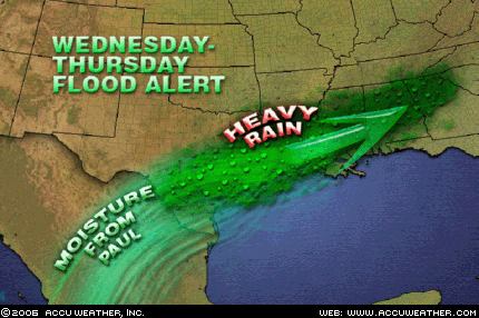
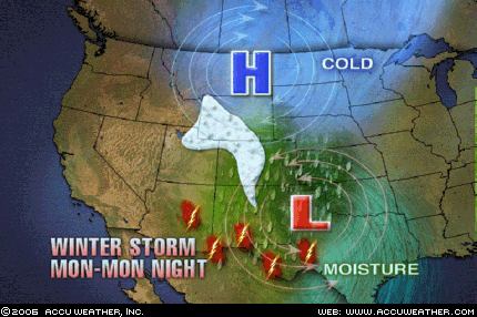
A tropical moisture is indicated over the Bahamas, Cuba, and Jamaica.

Jamaica's Meteorological Service issued the following statement today:

Thur..Tropical Wave passes over the island.

Fri..Surface to upper level trough over Bahamas and Cuba.

Sat..Surface to upper level trough over Bahamas and Cuba.

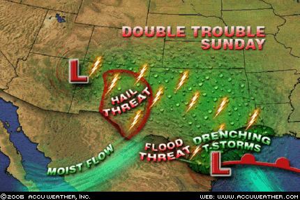
A storm system will advance into the Pacific Northwest and Intermountain West, pushing showers and thunderstorms into those areas.

Accuweather reported today:

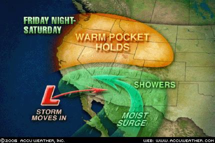
The West will also be wet, thanks to a slow moving upper-level low located off the coast of Northern California. As this low works closer to the coast tonight, colder air will be drawn south into California, lowering snow levels in the northern and central Sierra Mountains to 6,000 feet.