Saturday, March 26, 2016

March 23-26, 2016 Forecast Results

Here are the results of the last of the March forecasts posted on January 9th of this year. The basis for the long-range weather forecast was the alignment of Jupiter and Saturn. This particular segment of the forecast was for the March 23-26 period. You can read the original forecast here.

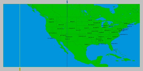
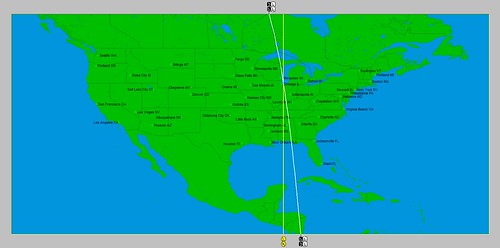
The area to be affected by the alignment centered on the 80th degree of west longitude which takes in the eastern Great Lakes and runs southward through the Carolinas. The New England area was also to be affected as can be seen from the astro-locality map below.

Jupiter Saturn

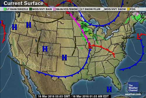
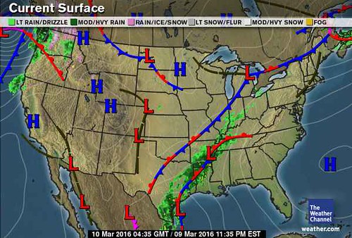
On the 24th, a low pressure system over the eastern Great Lakes and a trailing cold front aligned itself with the Saturn line running through 80 west longitude. The Weather Channel map below shows the low and front.

Mar 24

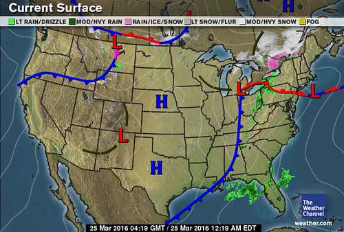
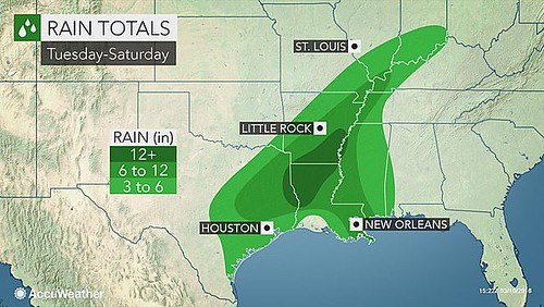
My forecast expected strong storms with potential to bring torrential downpours and gusty winds. The National Weather Service reported on the 25th that "a strong cold front moving eastward through the Ohio Valley this evening will continue to fuel heavy rainfall and thunderstorms across portions of the central/eastern Gulf Coast to the lower Great Lakes."

AccuWeather also pointed out that the Mid-Atlantic would experience blustery conditions which "will mark an end to the above-average warmth" that had prevailed over the region.

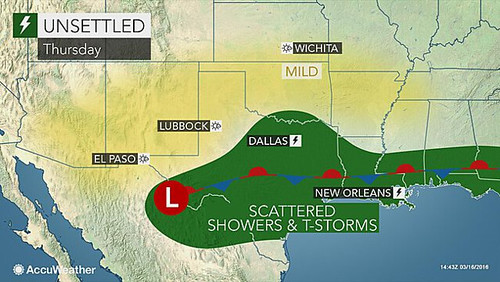
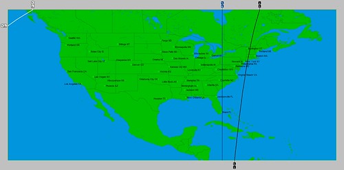
The New England area also participated in the effects of the low and front as seen in the AccuWeather map below for Friday, the 25th.

24 Late week

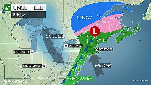
The National Weather Service declared that "snow and freezing rain will move into portions of northern New England with up to a quarter of an inch of ice possible."


Links to Other Long-range Weather Forecasts and Forecast Results

April 2016 Long-range Weather Forecast 
Hurricane Dolores Fulfills Long-range Weather Forecast
Hurricane Season 2015 Long-range Weather Predictions
Tropical Cyclone Hadi
Hurricane Erick Fulfills Long-range Forecast
Tropical Storm Andrea Fulfills Long-range Forecast!
Timing the Relief for Drought-Stricken U.S. Plains
Testing Astrometeorology Part 2
Hurricane Sandy Fulfills Long-range Weather Prediction!
Testing Astrometeorology Part 1
Hurricane Season 2011 Forecast Results
Hurricane Risk-Management
New Weather Alternative Website
Fulfilled Long-range Forecasts for Hurricane Season 2010
Introduction to the Weather Alternative

The Resurrection: Fact or Fiction?

Sunday, March 20, 2016

March 14-16, 2016 Forecast Results

In this post, I'll review the second of the March 2016 long-range forecasts that were published on January 9, 2016 in a post entitled March 2016 Long-range Forecasts. The second forecast period was that of March 14-16. The forecast called for storm potential over the the area from the western Great Lakes down through the Deep South with the likelihood of storms to focus over southern portions of the country.

The National Weather Service forecast for March 15-17 stated "Developing low pressure will be accompanied by significant rain across the Upper Mississippi Valley and Upper Midwest...

Accuweather headlines on the 14th stated "Election 2016: Severe storms may threaten voters in Missouri, Illinois on Tuesday" (March 15th)

Another headline of theirs read " Damaging winds, downpours to target Chicago, Indianapolis Tuesday"

The Weather Channel map below is for the 15th.

Mar 15

The Deep South became the focal point of a stationary front as shown in the Accuweather Map below for the 17th. Their headline warned "Late-week rain could aggravate flooding from Texas to Louisiana, Mississippi"

16 Texas Louisiana

Links to Other Long-range Weather Forecasts and Forecast Results

March 2016 Long-range Weather Forecasts
Hurricane Dolores Fulfills Long-range Weather Forecast
Hurricane Season 2015 Long-range Weather Predictions
Tropical Cyclone Hadi
Hurricane Erick Fulfills Long-range Forecast
Tropical Storm Andrea Fulfills Long-range Forecast!
Timing the Relief for Drought-Stricken U.S. Plains
Testing Astrometeorology Part 2
Hurricane Sandy Fulfills Long-range Weather Prediction!
Testing Astrometeorology Part 1
Hurricane Season 2011 Forecast Results
Hurricane Risk-Management
New Weather Alternative Website
Fulfilled Long-range Forecasts for Hurricane Season 2010
Introduction to the Weather Alternative

Mass Gains of Antarctic Ice Sheet Greater than Losses, NASA Study Reports (click to read)

nasastudymas

Wednesday, March 16, 2016

April 2016 Long-range Weather Forecast

During April of this year, Jupiter and Uranus will enter into an important alignment that will affect weather patterns over various parts of the United States. Alignments of this nature are known to result in strong cold fronts, increased precipitation, and heightened wind velocities. It may be helpful to review what weather patterns occurred during the last Jupiter-Uranus alignment in order to get a better understanding of its effects on the weather. Let's turn back the clock to October of last year.

Between the 19th and 22nd of October 2015, the planets Venus and Mars entered into a configuration that added impetus to the alignment of Jupiter and Uranus that was already underway. The locality map below shows that Uranus was positioned over the Rocky Mountains at about 110 west longitude while Jupiter was placed over the eastern Pacific at 141 west longitude.

Juipter Uranus 2015

On the 18th, the National Weather Service warned that a deep trough and upper level low would affect the western U.S. with the heaviest activity from northern Arizona to the northern Rockies where 1 to 2 inches of rain or higher could lead to flash flooding.

For the 20th, the forecast was for additional heavy rains for the Southwest and south-central Rockies.
Flash flooding was called for on the 21st for portions of the Southwest and Southern High Plains. The NWS warned of a stationary boundary over the Four Corners region and anomalous pools of moisture to increase the likelihood of heavy rain and/or intense rainfall over the region on the 22nd. Further south, Hurricane Patricia, with sustained winds of 200 mph, was being drawn toward the Uranus line at 110 west longitude.

April 2016

The next locality map shows the positions of Jupiter and Uranus during April 2016. Jupiter is represented by the blue line over the eastern U.S. at approximately 79 west longitude, while Uranus is shown by the black line off the U.S. West Coast.

Jupiter Uranus 2016

April 6-10, 2016

Between these dates the Sun will participate in the Jupiter-Uranus configuration adding important energy to the mix. The potential exists for a strong front to move into the West Coast states bringing precipitation. The eastern portion of the country should see a strong cold front that ignites storm activity from the eastern Great Lakes through the Mid-Atlantic area as it moves eastward.

April 22-25

At this time Venus aligns with the Jupiter-Uranus configuration and is likely to represent another round of fronts for the West Coast states and the eastern U.S.


Links to Other Long-range Weather Forecasts and Forecast Results

March 2016 Long-range Weather Forecasts
Hurricane Dolores Fulfills Long-range Weather Forecast
Hurricane Season 2015 Long-range Weather Predictions
Tropical Cyclone Hadi
Hurricane Erick Fulfills Long-range Forecast
Tropical Storm Andrea Fulfills Long-range Forecast!
Timing the Relief for Drought-Stricken U.S. Plains
Testing Astrometeorology Part 2
Hurricane Sandy Fulfills Long-range Weather Prediction!
Testing Astrometeorology Part 1
Hurricane Season 2011 Forecast Results
Hurricane Risk-Management
New Weather Alternative Website
Fulfilled Long-range Forecasts for Hurricane Season 2010
Introduction to the Weather Alternative

Friday, March 11, 2016

March 8-10, 2016 Forecast Results

The January 9, 2016 Weather Alternative post covered a long-range forecast for March 8-10. This forecast predicted strong storms bringing wind and rain to the area comprising the western Great Lakes southward through the Deep South due to the alignment of Jupiter and Saturn. The post discussed how the previous alignment of Jupiter and Saturn during August of 2015 had brought torrential downpours and gusty winds to the U.S. Deep South and to certain Mexican states at that time.

The following map was posted to show the general area to be affected.

March 8 2016

On March 8th, the National Weather Service warned " Showers and thunderstorms will develop along and ahead of the boundary from the Western Ohio Valley to the Lower Mississippi Valley/Southern
Plains and continue along and near the front through Thursday."

On the 9th, the NWS informed its readers with the headline "Heavy rain from parts of the Ohio Valley to the Lower Mississippi Valley and parts of the Southern Plains."

The following Weather Channel map provides a view of the low pressure area, rain, and front on the 9th.

Mar 09

Extensive flooding plagued Texas, Louisiana, and Arkansas. The following AccuWeather map shows rain totals from 3 to 12 inches primarily over the Deep South area.

10 Texas Louisiana

More forecasts for March are posted here.


Links to Other Long-range Weather Forecasts and Forecast Results
March 2016 Long-range Weather Forecasts
Hurricane Dolores Fulfills Long-range Weather Forecast
Hurricane Season 2015 Long-range Weather Predictions
Tropical Cyclone Hadi
Hurricane Erick Fulfills Long-range Forecast
Tropical Storm Andrea Fulfills Long-range Forecast!
Timing the Relief for Drought-Stricken U.S. Plains
Testing Astrometeorology Part 2
Hurricane Sandy Fulfills Long-range Weather Prediction!
Testing Astrometeorology Part 1
Hurricane Season 2011 Forecast Results
Hurricane Risk-Management
New Weather Alternative Website
Fulfilled Long-range Forecasts for Hurricane Season 2010
Introduction to the Weather Alternative

Why the New Definition of Tolerance Is Dangerous  (click to read)


Why Some People Will Not Be Convinced