Saturday, May 26, 2012

Long-range Effects of the May 20, 2012 Solar Eclipse Part 2

In the first post regarding the long-range effects of the May 20, 2012 Solar Eclipse on weather patterns, I talked about two areas that will be affected when the eclipse degree is triggered in the future by other planetary transits. The first area is about 350 miles east of the South Carolina coast around 73 west longitude and 33 north latitude, and the second area is off the eastern coasts of Nicaragua and Costa Rica in the southwestern Caribbean.

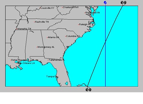
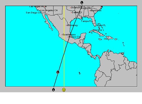
In this post, I'll mention other geographical areas that will be affected each time the eclipse degree is triggered. These times will match with the times mentioned in the first post because those are also based on triggers to the Solar Eclipse degree. So where are these other areas? The areas are circled in the astro-locality map below.

Eclipse 
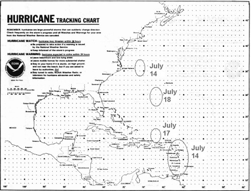
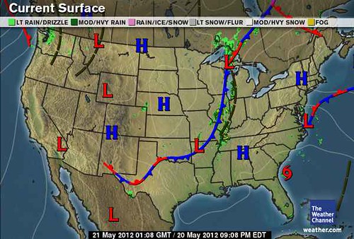
The circled areas all have one thing in common: they are areas where two planetary lines cross. Probably the most important one is the area over South Carolina because here the crossing is between the two slow-moving, outer planets Jupiter and Neptune. Let's look at the brief history of this crossing. As can be seen in the Weather Channel map below for May 20th (the day of the eclipse), Tropical Storm Alberto formed there the day before. May 20 Then on May 24th, Mercury conjoined the eclipse degree and Subtropical Storm Beryl began to form there as shown in the National Weather Service map below.

26- TS Beryl 
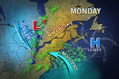
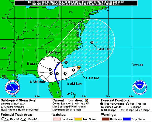
Similar arguments can be made about the other crossings. For example the crossings over the Mid-Atlantic and Northeast were also active after the eclipse began on the 20th. The map below, for the 21st, shows a cold front setting off storms over that area and moisture being pumped in from--of all places-- the circled area about 350 miles off of South Carolina. Accuweather reported that "The rain and clouds are advancing in from the Atlantic, but that moisture is not associated with Tropical Storm Alberto." When Mercury triggered the eclipse on the 24th, the Mid-Atlantic and Northeast once again experienced showers and thunderstorms. 21 Northeast 
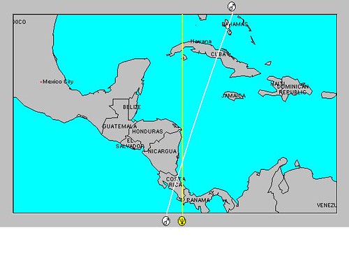
The last crossing is the one in the central Caribbean around 80W/17N. This became active around the 24th when Mercury triggered the eclipse degree and generated the beginnings of what is now Subtropical Storm Beryl. On the 25th, the NWS reported " SCATTERED STRONG CONVECTIVE PRECIPITATION...FROM 18N TO THE ATLANTIC OCEAN COAST OF CUBA BETWEEN 78W AND 83W...THIS AREA HAS BEEN CLOUDY AND RAINY FOR THE LAST FOUR TO FIVE DAYS. (That would mean since the time the eclipse took place) ENVIRONMENTAL CONDITIONS ARE EXPECTED TO BECOME MORE CONDUCIVE FOR THE FORMATION OF A SUBTROPICAL OR TROPICAL CYCLONE BY SATURDAY OR SUNDAY.

So in addition to the times and places mentioned in the first post, the following weather patterns should be expected on the dates listed below:

1- Tropical systems to affect the area in and around South Carolina. If not an actual tropical system, the weather pattern may manifest as a subtropical system or as an increase in troipcal moisture being pumped into the region resulting in drenching rains.

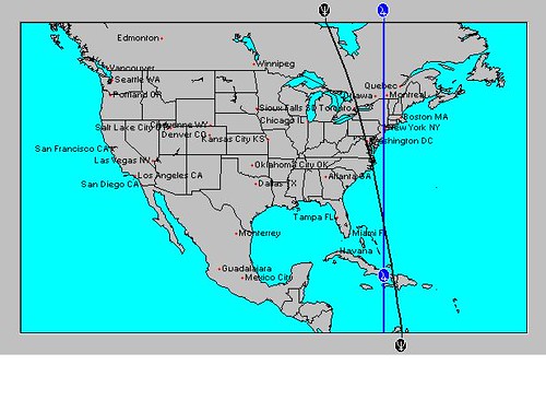
2- Thunderstorm activity over the Mid-Atlantic and Northeast.

3- Tropical system development or strong troughs to develop in the central Caribbean area resulting in deep layer moisture and precipitation.

4- The approximate dates in 2012:
June 13-14
August 21-24
September 1-3
October 2-4
October 6-8
October 28-30
November 10-14
November 20-22

Long-range effects of the May 20, 2012 Solar Eclipse
July 14-19, 2012 Hurricane Season Outlook
June 22-30, 2012 Long-range Weather Forecast
June 10-12, 2012 Long-range Weather Forecast
June 4-7, 2012 Long-range Weather Forecast
Hurricane Season 2011 Forecast Results
Hurricane Risk-Management
Texas Summer 2012
New Weather Alternative Website
Overview of UK Winter 2012-13
The Winters of 2011-14
Fulfilled Long-range Forecasts for Hurricane Season 2010
Introduction to the Weather Alternative

Are There Logical Reasons to Believe that God Exists?

Saturday, May 19, 2012

Long-range effects of the May 20, 2012 Solar Eclipse

In astrometeorology (the study of planetary influences on earthly weather patterns), solar eclipses are useful tools used in forecasting future weather patterns. A solar eclipse is much like a New Moon in this regards except that it has a longer life span. The influence of a solar eclipse is thought to be active for about 3 to 3 and a half years. At the exact moment of conjunction between the Sun and Moon a chart or map is set up. Note is taken of where all the planets were angular (rising, setting, exactly above, and exactly beneath the observer's reference point) at the time. These positions then are used to determine where certain weather patterns will develop and at what times.

The solar eclipse of May 20, 2012 sets up some important sensitive points in the northern and western hemispheres that will be activated over the coming months and carry the promise of severe weather when activated. Here are some brief explanations and time frames. Southeast The first place lies about 350 miles off the South Carolina coast. Here we see a crossing between the Sun and Moon, which were setting at that time, and Mars, which was directly overhead. The idea is that when these positions are activated later on by other planets arriving at those zodiacal degrees they held, certain weather patterns will develop there.

June 13-14
On these dates, the planet Jupiter will arrive at the exact degree the Sun and Moon held at the time of eclipse, and Venus will arrive at the square or 90 degree point to the position that Mars held. This carries the potential for the development of a tropical system around this area (73W/33N) in and around these dates.

Central America

An even more important set up occurs off the eastern coasts of Nicaragua and Costa Rica as seen in the map below. Caribbean Here we find that at the time of the eclipse the Sun and Moon were setting over this area and the planet Neptune was directly below any observer at that point. In astrometeorology, Neptune is known for its tendency to increase tropical moisture. This implies that, when activated, tropical systems may develop here--or at least tropical moisture will be abundant even if a tropical low does not specifically form.

August 21-24
At this time Sun will trigger the solar eclipse degree and oppose Neptune. Watch for a possible tropical system or heavy rains to affect the area in and around the east coasts of Nicaragua and Costa Rica.

September 1-3
Around this time Mercury will activate the solar eclipse and oppose Neptune once again increasing the likelihood of heavy rains or a tropical system over the eastern coasts of Honduras and Nicaragua. At this time the abovementioned area about 350 miles of the South Carolina coast will also be activated, indicating a possible tropical system or severe weather there.

October 2-4
Venus will spark the solar eclipse now and also oppose Neptune off the eastern coasts of Nicaragua and Costa Rica. The Venus-Neptune combination charges the atmosphere with saturating humidity provoking heavy downpours. This may manifest as a tropical system.

October 6-8
Right on the heels of Venus' opposition to Neptune we find Mars triggering the solar eclipse and squaring Neptune over the same area. Torrential downpours from acute storms (possibly a tropical system) correlate with Mars-Neptune aspects.

October 28-30
Mercury will perform the same manuever instigating tropical rains in and around Nicaragua and Costa Rica.

November 10-14
Both Mercury and Neptune will now activate the solar eclipse and square each other. Indications in another key chart adds to this itimating that any storm system developing over Nicaragua and Costa Rica now could be very powerful.

November 20-22
The Sun activates the solar eclipse and Neptune increasing tropical moisture while other indications show Mercury and Mars add powerful winds into the mix. This sounds like a tropical system over Nicaragua and Costa Rica.

Based on similar astrometeorological long-range techniques, I was able to predict 10 tropical systems that developed during Hurricane Season 2011. Hurricane Season 2011 Forecast Results

July 14-19, 2012 Hurricane Season Outlook
June 22-30, 2012 Long-range Weather Forecast
June 10-12, 2012 Long-range Weather Forecast
June 4-7, 2012 Long-range Weather Forecast
Hurricane Season 2011 Forecast Results
Hurricane Risk-Management
Texas Summer 2012
New Weather Alternative Website
Overview of UK Winter 2012-13
The Winters of 2011-14
Fulfilled Long-range Forecasts for Hurricane Season 2010
Introduction to the Weather Alternative

Monday, May 14, 2012

July 14-19, 2012 Hurricane Season Outlook

We continue to look at how the Uranus-Pluto and Jupiter-Neptune squares will possibly affect weather patterns during Hurricane Season 2012. This post looks at the time period between July 14-19. At this time Uranus and Mercury will make their retrograde stations, the Sun will square Saturn, and more importantly, Mars will trigger the close Uranus-Pluto square by first squaring Pluto and then opposing Uranus on the 17th and 18th.

Aspects of this sort by Mars to Uranus and Pluto usually coincide with very energetic weather patterns provoking high wind velocities and dangerous atmospheric conditions. There is a contrary influence at work during this time as Jupiter moves into a sextile aspect with Uranus. This influence usually manifests with fair weather patterns. Be that as it may, I think that it will be difficult for that aspect to completely override the Mars-Uranus-Pluto influence. track_chart The above map shows the locations that various planetary alignments are likely to affect as we approach the Mars aspects on July 17th and 18th. The 14th shows that there is the potential for a storm system to develop around the Windward Islands. There is also another influence setting up off the North Carolina and Virginia coasts. The 17th highlights an area north of Puerto Rico, and the 18th pinpoints another just southwest of Bermuda.

Except for the area off the North Carolina and Virginia coasts on the 14th, the other areas seem to form a natural progression from south to north between the 14th and the 18th starting at the Windward Islands. The key Solar Ingress chart for the season places the Uranus-Pluto influence over the New England area so one possibility is that a tropical system forms around the 14th over the Windward Islands and moves northward with its eyes on New England.

Of course, there is always the possibility that some other type of severe weather is indicated by these alignments that is not tropical in nature. In such a case, other types of severe storms may affect the New England area at this time.

June 22-30, 2012 Long-range Weather Forecast

June 10-12, 2012 Long-range Weather Forecast

June 4-7, 2012 Long-range Weather Forecast

Hurricane Season 2011 Forecast Results

Hurricane Risk-Management

Texas Summer 2012

New Weather Alternative Website

Overview of UK Winter 2012-13

The Winters of 2011-14

Fulfilled Long-range Forecasts for Hurricane Season 2010

Introduction to the Weather Alternative

Monday, May 07, 2012

June 22-30, 2012 Long-range Weather Forecast

This is the next in a series of posts that analyzes the squares between Jupiter-Neptune and Uranus-Pluto and their effect on weather patterns. Both these square are exact at the end of June. The square between Jupiter and Neptune indicates predominant low barometric pressure and above normal precipitation. The configuration between Uranus and Pluto brings storm emergencies with sharp dips in temperatures and erratic gusty winds.

The Jupiter-Neptune Square

This aspect is exact on June 24th and 25th and is later triggered again on June 28th. The Solar Ingress chart for the summer season places Neptune along the 101st degree of west longitude which passes through western Texas, along the Front Range of the Rockies, and through the High Plains. Jupiter affects eastern Texas, the central Mississippi River Valley, and the Great Lakes. These are areas that should generally receive above normal precipitation at this time.

As we look at the combined influence of Jupiter and Neptune in other key charts such as Solar Eclipse charts and New and Full Moon charts, we get some other interesting scenarios. For example, the New Moon chart of June 19th places an important crossing of Jupiter and Neptune in the western Atlantic about emphasizing the area from Haiti northward for about 550 miles as shown in the astro-locality map below.
   Jupiter Neptune
This area could be the spawning grounds of a tropical system. Since Jupiter and Neptune also affect the coasts of North Carolina and Virginia and continue into the Northeast, the chance exists of a tropical system heading towards those areas at this time. Sometimes it's not an actual tropical system that forms. This configuration can represent the presence of abundant tropical moisture that is pumped up into the area.

As Jupiter perfects its square to Neptune, it will also trigger the Solar Eclipse of November 25, 2011. This will sensitize the 96th degree of west longitude which runs through Dallas, Texas northward into the Plains. Neptune also affects Texas and the Plains. This could argue that tropical moisture from the Gulf of Mexico is pulled northward into Texas pushing its way into the Plains. The mechanism that brings this about could be a low pressure area, front, or even a tropical system in the Gulf.

Another interesting scenario develops in the Solar Ingress chart as shown in the astro-locality map below. Ju Ne Mex


Here we see Jupiter and Neptune crossing in the eastern Pacific at 101 west longitude and 10 north latitude or about 550 miles south of the Mexican coast. This indicates the possibility of a tropical system forming around this area now.

The Uranus-Pluto Square

The Uranus-Pluto square is exact on June 24th but is triggered a bit earlier on the 22nd. The Moon will activate it again on the 27th, and finally the Sun will square and oppose them on the 29th. The Solar Ingress chart has them affecting the eastern U.S. and New England. We've already seen that the Jupiter-Neptune configuration affects the East Coast, so this is another influence happening simultaneously.

Two other places that might be worth watching are in and around the state of Mississippi where severe weather could develop and around the 29th about 750 miles west of Cabo San Lucas (121 west/23N) where a tropical system could develop or pass.

June 10-12, 2012 Long-range Weather Forecast

June 4-7, 2012 Long-range Weather Forecast
Hurricane Season 2011 Forecast Results
Hurricane Risk-Management
Texas Summer 2012
New Weather Alternative Website
Overview of UK Winter 2012-13
The Winters of 2011-14
Fulfilled Long-range Forecasts for Hurricane Season 2010
Introduction to the Weather Alternative