Saturday, April 27, 2013

Forecast Results: Jupiter-Neptune and Heavy Rain

I posted some long-range weather forecast back in July of 2012 based on the Jupiter-Neptune square of June 25, 2012. I focused on two places that were affected by the alignment. The first was in the Philippines. There, Neptune affected the line of longitude passing directly through the islands while Jupiter was setting as shown in the map below. Phil

The very next day, Tropical Depression Doksuri formed just east of the Philippines affecting the islands on its way toward Hong Kong.

I listed some dates when this crossing would be activated. I expected heavy rain at those times. Here are the results.

August 25, 2012
The Weather Channel reported on August 26th that Typhoon Bolaven was churning in the Philippine Sea with maximum sustained winds of 130 mph.

September 2, 2012
Nothing reported.

October 5, 2012
Tropical Storm Gaemi was located just west of the Philippines destined for Vietnam with heavy rainfall and inland flooding for the Indochina Peninsula.

October 11, 2012
Typhoon Prapiroon developed on the 5th and by the 7th it had entered what is called the Philippine Area of Responsibility, which is essentially the area in and around the Philippines. In this case Prapiroon was in the Pacific Ocean just east of the Philippines.

November 2, 2012
Nothing reported.

November 10, 2012
Tropical Depression 25W moved over the Philippines on November 11th and then entered the South China Sea.

November 24, 2012
Typhoon Bopha formed on the 23rd but very far east of the Philippines. By December 2nd it entered the Philippine Area of Responsibility and was renamed Pablo. It hit the Philippines on December 3rd--too far removed, however, from the forecast date to be counted as a hit.

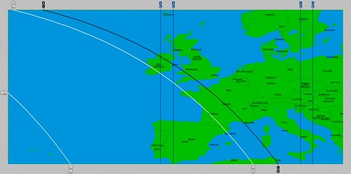
New England and Eastern Canada

The original forecast also mentioned another crossing related to Jupiter-Neptune. This was over eastern Canada as shown in the map below.
Newfoundland

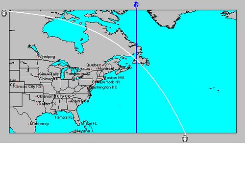
The day after the Jupiter-Neptune square, heavy rain causing localized flooding hit New England and eastern Canada.

August 25, 2012
On the 26th, northern New England received about an inch of rain.

September 2, 2012
On the 3rd, southern Maine received about from 1 to 3 inches of rain. On the 4th, parts of New England saw rainfall of 1 inch or greater.

October 5, 2012
On the 4th, New England registered between 0.25 to 1 inch of rain.

October 11, 2012
Nothing reported.

November 2, 2012
By the 1st, Hurricane Sandy's remnants were leaving the Northeast and New England.

November 10, 2012
On the 12th, a strong cold front swept off the coast with rain and showers.

November 24, 2012
On the 23rd, rain, snow, and windy conditions over New England.

Ireland Weather June 5-10, 2013
California Water Shortage Part 2
April 2013 Heat
California Water Shortage Spring 2013 Forecast
Timing the Relief for Drought-Stricken U.S. Plains
Testing Astrometeorology Part 2
Hurricane Sandy Fulfills Long-range Weather Prediction!
Testing Astrometeorology Part 1
Long-range effects of the May 20, 2012 Solar Eclipse
Long-range effects of the May 20, 2012 Solar Eclipse Part 2
Hurricane Season 2011 Forecast Results
Hurricane Risk-Management
New Weather Alternative Website
Overview of UK Winter 2012-13
The Winters of 2011-14
Fulfilled Long-range Forecasts for Hurricane Season 2010
Introduction to the Weather Alternative

Has Dawkins Lost? Check out the audio link below
Has Dawkins Lost? | Reasonable Faith

Wednesday, April 24, 2013

Ireland Weather June 5-10, 2013

A number of planetary cycles culminate between the 5th and 10th of June and promise a severe weather pattern for Ireland. These cycles include 1) Neptune's retrograde station, 2) Mars' square to Neptune, 3)Mercury's opposition to Pluto, and 4) Mars' activation of the most recent lunar eclipse of May 24th. The astro-locality map below shows how a number of planetary positions affect the Emerald Isle.

Ireland

Let's see how each of these cycles has operated in the recent past to get an idea of what might happen to weather conditions over Ireland and the surrounding area.

1- Neptune's Retrograde Station
Last year, Neptune's station took place on June 4th over 101 west longitude which runs through the U.S. Plains states and Texas. By the 6th, meteorologists were warning of severe weather to break out of the eastern Rockies and the Plains bringing large hail and wind damage. The High Plains took a pounding from multiple rounds of severe thunderstorms. A repeat performance was offered on the 7th and 8th with torrential downpours, large hail, and locally damaging wind gusts.

2- The Mars-Neptune Square
The combination of Mars and Neptune usually result in freak weather changes due to rising temperatures, increasing humidity, and low pressure areas. Last year, the Mars-Neptune square of October 7, 2012 was placed along 71 west longitude passing through New England and the Bahamas. At that time, an upper level disturbance and a developing storm offshore brought rain to the eastern Mid-Atlantic through New England. A tropical cyclone attempted to form near the Bahamas as well.

3- The Mercury-Pluto Opposition
The last Mercury-Pluto opposition was on June 12, 2012. The Full Moon chart placed the two planets over the U.S. Northeast. On the 12th, drenching downpours shifted into the Northeast due to a surge of tropical moisture creating urban and small stream flooding.

4- Mars Activating Lunar Eclipse
The lunar eclipse of June 15, 2011 was activated by the opposition of Mars on July 25 of the same year. The eclipse was overhead at 123 west longitude which runs along the U.S. Pacific Northwest coast. At that time, an upper level low brought showers and storms to the Northwest.

Conclusion
A number of these planetary alignments brought some impressive weather conditions. The potential seems to be there for a similar response over Ireland and surrounding areas.

California Water Shortage Part 2
April 2013 Heat
California Water Shortage Spring 2013 Forecast
Timing the Relief for Drought-Stricken U.S. Plains
Testing Astrometeorology Part 2
Hurricane Sandy Fulfills Long-range Weather Prediction!
Testing Astrometeorology Part 1
Jupiter-Neptune and Heavy Rain
Long-range effects of the May 20, 2012 Solar Eclipse
Long-range effects of the May 20, 2012 Solar Eclipse Part 2
Hurricane Season 2011 Forecast Results
Hurricane Risk-Management
New Weather Alternative Website
Overview of UK Winter 2012-13
The Winters of 2011-14
Fulfilled Long-range Forecasts for Hurricane Season 2010
Introduction to the Weather Alternative

Getting Happiness Down to a Science

Saturday, April 20, 2013

Revisiting the Mars-Saturn Conjunction of August 2012

In July of 2012, I posted a number of forecasts regarding the Mars-Saturn conjunction of August 15, 2012. I then posted the results of the initial forecast to see how it came out. In that first forecast, I also included upcoming dates when the conjunction would be triggered. As I look back at these now, I see that the triggers to the conjunction passed without much fanfare with regards to the weather. I noticed that all of the planets triggering Mars-Saturn were from the faster moving inner planets. It's a different story when the outer planets (Mars, Jupiter, Saturn,Uranus, Neptune, and Pluto) trigger these conjunctions. I've posted about these outer planet triggers before regarding Typhoon Ma-On that hit Japan in July of 2011.

When we look at what happened when Mars triggered the conjunction degree later on, things are quite different. For example, On December 19, 2012, Mars squared this degree. As you recall, the Mars-Saturn conjunction affected the Plains running through 100 west longitude. US

On the 19th, a powerful winter storm gathered strength over Wyoming and Colorado and spread blizzard conditions across the Plains and the Midwest delivering snow and gusty winds. The map below is for the 20th as it moves eastward.

Dec 20

Just recently, Mars triggered the conjunction again, along with the Sun as they both opposed the Mars-Saturn conjunction degree. On the 13th, winter storm Xerxes (as it's called by the Weather Channel) brought heavy snow to the northern Plains states. Then another band of significant precipitation reached Wyoming and Colorado leaving about 6 inches of snow across the higher elevations of the latter. Gusty winds hit the area as well. By the 16th, the winter storm, now dubbed "Yogi," was now affecting Nebraska, South Dakota, and Kansas with 1 to 12 inches of snow. The storm even dipped down into Oklahoma and West Texas. Damaging wind gusts, large hail, and tornadoes were also part of its legacy.

In upcoming posts we'll work with this method and see how these outer planet triggers will affect the Uranus-Pluto square that will form this May.

California Water Shortage Part 2
April 2013 Heat
California Water Shortage Spring 2013 Forecast
Timing the Relief for Drought-Stricken U.S. Plains
Testing Astrometeorology Part 2
Hurricane Sandy Fulfills Long-range Weather Prediction!
Testing Astrometeorology Part 1
Jupiter-Neptune and Heavy Rain
Long-range effects of the May 20, 2012 Solar Eclipse
Long-range effects of the May 20, 2012 Solar Eclipse Part 2
Hurricane Season 2011 Forecast Results
Hurricane Risk-Management
New Weather Alternative Website
Overview of UK Winter 2012-13
The Winters of 2011-14
Fulfilled Long-range Forecasts for Hurricane Season 2010
Introduction to the Weather Alternative

The Truth About GMOs

Saturday, April 13, 2013

California Water Shortage Part 2

In the first California Water Shortage post, I gave some dates during the spring season when the state might get some rain and some other dates that showed dry periods. In this post, I'll talk about some other major planetary cycles that will affect California and the West Coast and thus add some other influences not mentioned in the first post.

May 20, 2013 - Uranus square Pluto

The first event that needs to be added to the calendar is the Uranus-Pluto square on May 20th. The astro-locality map below shows that this aspect falls over the U.S. West Coast.

Uranus Pluto

Since the square represents atmospheric disturbances, and Uranus signifies cold air masses with erratic winds, in stands to reason that the West Coast states could experience a strong cold front or low pressure area in and around this time that brings windy conditions and possibly some precipitation to the area.

June 7, 2013 - Neptune's Retrograde Station

The next important event is Neptune's retrograde station. One of Neptune's characteristic influences is to increase moisture. Notice from the astro-locality map below, Neptune makes a crossing with the Sun off the U.S. West Coast.

Neptune Rx

This means that moisture should be funneled up over the area in the days following. The original forecast in the first post for June 7-8 was as follows:

Mercury makes some important aspects to Uranus and Pluto. This may bring an anomalous weather pattern to the Pacific Northwest and California. It may mean stormy or windy conditions or perhaps extremes of cold before and after these dates.

Now, with the added information regarding Neptune's retrograde station at this time, an increase in moisture resulting in more of a chance of precipitation is indicated along with the above forecast. It would be wise to also extend the time period mentioned to include June 7-12 as well.

April 2013 Heat
California Water Shortage Spring 2013 Forecast
Timing the Relief for Drought-Stricken U.S. Plains
Testing Astrometeorology Part 2
Hurricane Sandy Fulfills Long-range Weather Prediction!
Testing Astrometeorology Part 1
Mars Conjunct Saturn August 15, 2012
Jupiter-Neptune and Heavy Rain
Long-range effects of the May 20, 2012 Solar Eclipse
Long-range effects of the May 20, 2012 Solar Eclipse Part 2
Hurricane Season 2011 Forecast Results
Hurricane Risk-Management
New Weather Alternative Website
Overview of UK Winter 2012-13
The Winters of 2011-14
Fulfilled Long-range Forecasts for Hurricane Season 2010
Introduction to the Weather Alternative

Has Whole Foods Succumbed to GMO Pressure?

U

Sunday, April 07, 2013

April 2013 Heat

The next Sun-Mars conjunction will take place on April 17, 2013. When Mars is configured with the Sun the temperature rises. This aspect takes place about every two years.

The last conjunction was on February 4, 2011. The chart for that winter season placed the conjoined planets just off the U.S. West Coast. The Weather Channel reported on February 5th that temperatures would be 5 to 10 degrees above average across the Great Basin and the West Coast. Meteorologists also pointed out that the warmer air was thawing out the Rockies as temperatures increased.

Summer_2010_ClipArt9_SunWearingGlasses

April 17-21, 2013

The key chart for the 2013 spring season places the Sun-Mars conjunction over Newfoundland and Labrador in Canada. Increasing temperatures over this area may give way to unsettled conditions which sometimes occur with Sun-Mars conjunctions.

Another key chart, the Full Moon chart of March 27th, places the Sun-Mars conjunction over California and the Pacific Northwest. As mentioned in a previous post about the California Water Shortage, this should bring warmer and drier conditions to the area.

tumblr_m5x5f6fTBo1r9qhhio1_500

Still other key charts show the Sun-Mars conjunction affecting a large portion of the United States. We may see a general warm up spreading across the country during the days following the April 17th conjunction.

California Water Shortage Spring 2013 Forecast
Timing the Relief for Drought-Stricken U.S. Plains
Testing Astrometeorology Part 2
Hurricane Sandy Fulfills Long-range Weather Prediction!
Testing Astrometeorology Part 1
Mars Conjunct Saturn August 15, 2012
Jupiter-Neptune and Heavy Rain
Long-range effects of the May 20, 2012 Solar Eclipse
Long-range effects of the May 20, 2012 Solar Eclipse Part 2
Hurricane Season 2011 Forecast Results
Hurricane Risk-Management
New Weather Alternative Website
Overview of UK Winter 2012-13
The Winters of 2011-14
Fulfilled Long-range Forecasts for Hurricane Season 2010
Introduction to the Weather Alternative

Blueberries Faked in Cereals and Other Food Products