 The following long-range forecasts indicate the time and place of likely hurricane or tropical storm activity for the United States.
Forecast
Sept 2-5, 2010
Sun-Mercury conjunctions during hurricane season often coincide with hurricane or tropical storm landfalls at times when Mercury is in retrograde motion. Of course, certain key charts must place the planets over hurricane prone areas of the States in order for this to happen. The Last Quarter Moon of Sept 1st presents this type of setup over longitude 78 west. This line passes through the Carolinas and Virginia.
Sun-Mercury conjunctions usually play out as very windy and stormy conditions. This is why hurricanes often result. If not an actual tropical system, the Mid-Atlantic could face storms producing gusty winds.
Forecast
Sept 18-23, 2010
During this period there exists the possibility of a low pressure area forming in the Gulf of Mexico about 200 miles south of Mobile, Alabama. Another area that could see tropical activity is along the west coast of Florida. So we may be dealing with a tropical system at this time that is drawn from the Gulf to the west coast of Florida. It could also manifest as a strong cold front that triggers severe thunderstorms.
Hurricane Season 2010--Forecasts for June
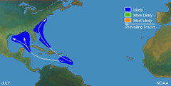
Hurricane Season 2010--Forecast for July
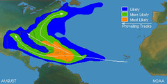
Hurricane Season 2010--Forecasts for August
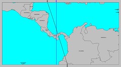
Hurricane Season 2010--Central America Part I
Introduction to the Weather Alternative
How Long-Range Forecasts Are Made
Success is the child of drudgery and perseverance. It cannot be coaxed or bribed; pay the price and it is yours.—Orison Swett Marsden
A man either lives life as it happens to him, meets it head-on and licks it, or he turns his back on it and starts to wither away.—Gene Roddenberry
You may have a fresh start any moment you choose, for this thing that we call “failure” is not the falling down but the staying down.—Mary Pickford