Here are the results of the long-range weather forecasts for August 2005. These forecasts were prepared at the end of July 2005.
Forecast
August 4-5, 2005:
Showers are indicated over eastern Maine and Nova Scotia.
Results
Aug 4, 2005: (The Weather Channel)
As the cold front infiltrates northern New England and Upstate New York on Friday, high temperatures will reach into the 90s...Scattered thunderstorms will erupt out ahead of the front.
Aug 5, 2005: (The Weather Channel)
After a hot, muggy and in some cases thundery Friday from New England to Virginia, the passing cold front will bring less humid air...
Forecast
August 5-6, 2005:
1) Some unsettled weather is shown over the Great Basin area.
2) Warm and fair throughout the Mississippi Valley area.
3) Warm conditions that may break out in thunderstorms over New York State and surrounding area.
Results
Aug 5, 2005: (National Weather Service)
1) The NWS reported flash flood warnings for Utah and Nevada.
Aug 5, 2005: (The Weather Channel)
2) Except for scattered showers and thunderstorms lingering from the Ohio River and southern Missouri southward, most of the Midwest will enjoy a rain-free weekend.
Aug 5, 2005: (National Weathe Service)
3) ...HIGH HEAT AND HUMIDITY FOR NEW YORK CITY THIS AFTERNOON...
Forecast
August 8-9, 2005:
1) Front setting off thunderstorms over the Pacific Northwest.
2) Possible tropical storm and/or hurricane formation over the Lesser Antilles (61 West/16 North)
Results
Aug 8, 2005: (National Weather Service)
1) ISOLATED THUNDERSTORMS WILL RETURN ACROSS THE CENTRAL AND EASTERN OREGON MOUNTAINS TODAY AND INTO THIS EVENING.
(The Weather Channel)
Gusty afternoon winds will prevail along the immediate coast from the Olympic Peninsula to the Mexican border.
Aug 8, 2005: (National Weather Service)
2) CENTRAL ATLC TROPICAL WAVE IS ALONG 60W/61W S OF 19N...SCATTERED MODERATE/ISOLATED STRONG CONVECTION IS FROM 14N-18N E OF 65W TO OVER THE LEEWARD ISLANDS. THIS ACTIVITY WILL MOVE E OF THE LEEWARDS OVER THE NEXT COUPLE OF HOURS.
Forecast
August 9-11, 2005:
1) A stormy period is indicated for the Rockies. The weather pattern then continues over the Plains.
2) Storms are on the increase over New England.
Results
Aug 10, 2005: (National Weather Service)
1) RIVERTON WY AN UPPER LEVEL DISTURBANCE WILL MOVE ACROSS NORTHWEST AND NORTH CENTRAL WYOMING...THE POSSIBILITY OF STRONG THUNDERSTORMS WITH SMALL HAIL...FREQUENT LIGHTNING...WIND GUSTS UP TO 45 MPH AND VERY HEAVY RAIN.
1) COLORADO...A VERY MOIST AIRMASS IS IN PLACE ...THUNDERSTORMS CAPABLE OF PRODUCING LARGE HAIL AND LOCALLY HEAVY RAINFALL OVER THE URBAN CORRIDOR AND NORTHEAST COLORADO PLAINS.
(The Weather Channel)
1) The Northern Plains will be stormy through the early morning hours Thursday as a thunderstorm complex will make its way across Nebraska and into the Missouri River Valley. The primary threat with this stormy weather will be hail and wind, however the isolated tornado cannot be ruled out.
Aug 9, 2005: (The Weather Channel)
2) Showers and thunderstorms will threaten areas today from the Appalachians to the Mid-Atlantic and into New England.
Forecast
August 12-14, 2005:
1) Windy conditions affect the Pacific Northwest as a front pushes through.
2) Breezy to windy conditions and most likely cooler temps affect the Great Basin and Rocky Mountains.
3) Windy weather is also shown for the Mid-Atlantic region through New England.
Results
Aug 11, 2005: (The Weather Channel)
1 & 2) ...the accompanying low humidity and locally gusty winds are the perfect enablers for the many wildfires raging in parts of Washington, Oregon, Idaho, and western Montana...From the Rockies eastward, cool Canadian high pressure will slide southward Friday (Aug 12) and over the weekend...clouds showers will add to the chill. High temperatures in Cheyenne and Denver could be in the 50s Saturday (Aug 13).
Aug 11, 2005: (National Weather Service)
3)...THUNDERSTORMS WITH GUSTY WINDS...HAIL AND HEAVY RAIN WILL
AFFECT SOUTHWEST MAINE THROUGH 415 PM..
Aug 12, 2005: (National Weather Service)
3)...TORNADO WARNING FOR... NORTHERN PIKE COUNTY IN NORTHEAST PENNSYLVANIA...THIS STORM IS PRODUCING DESTRUCTIVE STRAIGHT LINE WINDS.
Aug 13, 2005: (National Weather Service)
3) UPTON NY...A STRONG SOUTHWEST WIND WILL USHER HOT AND HUMID CONDITIONS...
Forecast
August 16-18, 2005:
1) Warmer conditions are shown for the Plains as a southerly airflow kicks in. If enough moisture is available, thunderstorms will ensue.
2) Rising temperatures over the Northeast and New England with the potential to trigger thunderstorms.
Results
Aug 17, 2005: (Accuweather)
1) Across the southern Plains, a warm, southerly wind will blow, allowing temperatures to heat up into the 90s in most places.
Aug 16, 2005: (The Weather Channel)
2) The weekend heat in the Northeast is now just a memory as much more comfortable air is in place. Highs across much of the region will remain in the 70s today.
Forecast
August 17-19, 2005:
A warm period is shown for the West Coast and Great Basin areas.
Results
Aug 18, 2005: (The Weather Channel)
Temperatures for the Pacific Coast return to average as highs will climb back into the 70s for Seattle and low 80s for Portland.
Aug 19, 2005: (The Weather Channel)
High pressure will push into the Pacific Northwest allowing temperatures to warm into the 80s and 90s from Seattle to down to Medford and east to Boise. The Idaho Panhandle will see temperatures climb into the 90s...
Forecast
August 20-22, 2005:
Another stormy period is indicated for New England. There is a chance that this could be a tropical system.
Results
August 21, 2005: (National Weather Service)
...SCATTERED STRONG THUNDERSTORMS WILL AFFECT CENTRAL NEW HAMPSHIRE...THESE STORMS MAY DEPOSIT UP TO ONE AND ONE-HALF INCHES OF RAIN IN LESS THAN 40 MINUTES...
TAUNTON MA...A LINE OF STRONG THUNDERSTORMS WITH THE POTENTIAL TO PRODUCE WIND GUSTS TO 40 MPH ALONG A LINE EXTENDING FROM...FRAMINGHAM TO...PUTNAM TO...MANSFIELD...THESE STORMS MAY ALSO CONTAIN VERY HEAVY RAINFALL.
Forecast
August 24-28, 2005:
1) A strong cold front will enter the Pacific Northwest and set off storms as the front advances through the Great Basin area.
Results
August 27, 2005: (The Weather Channel)
A cold front will bring much cooler temperatures and showers to parts of the Pacific Northwest late in the weekend (Sunday Aug 28) into Monday. Seattle and Portland which have consistently peaked in the mid 80s and upper80s/low 90s for much of this month will see their thermomters dip into the 60s and 70s as we head into early next week.
2) The potential for tropical storm development is shown in and around 117 West Longitude and 20 North Latitude. This lies in the eastern Pacific about 560 miles southwest of the tip of Baja California.
Results
August 27, 2005: (National Weather Service)
TROPICAL STORM IRWIN IS CENTERED NEAR 17.4N 112.6W AT 27/1500
UTC MOVING W AT 10 KT. MAXIMUM SUSTAINED WIND SPEED IS 35 KT WITH GUSTS TO 45 KT...
August 28, 2005: (National Weather Service)
TROPICAL DEPRESSION IRWIN CENTERED NEAR 16.9N 115.5W...OR 480 NM SW OF THE SOUTHERN TIP OF BAJA CALIFORNIA...AT 28/1500 UTC
3) Tropical storm development is likely near 142 West Longitude and 18 North Latitude.
Results
August 24-28, 2005:
No Tropical storm development reported.
4) Texas and the Plains will see an active weather pattern at this time resulting in storms producing wind, hail, and possible tornadoes.
Results
August 25, 2005: (The Weather Channel)
The Midwest will experience more active storms through Friday (Aug 26). Flood watches are in effect for parts of southern Nebraska, Kansas and Missouri. Parts of Kansas received six to nine inches of rain on Wednesday night (24th) into early Thursday (25th). More rain and thunderstorms are likely in these areas as a vigorous cold front approaches from the northern Plains overnight into Friday. This cold front will offer widespread gusty thunderstorms for the region with travel and air port headaches due to the storms.
5) Moisture is also drawn up from the Gulf of Mexico over the Gulf Coast States of Louisiana, Mississippi, and Alabama. As the moisture surges northward toward the Central Mississippi Valley, storms will result.
Results
August 25, 2005: (National Weather Service)
NATIONAL WEATHER SERVICE LAKE CHARLES LA
.A STRONG HIGH PRESSURE SYSTEM IN THE MID LEVELS OF THE ATMOSPHERE WILL HELP TEMPERATURES SOAR TO THE MID TO UPPER 90S THIS AFTERNOON. HIGH LOW LEVEL MOISTURE WILL ALSO BE IN PLACE RESULTING IN OPPRESSIVE CONDITIONS.
NATIONAL WEATHER SERVICE JACKSON MS
THE NATIONAL WEATHER SERVICE IN JACKSON HAS ISSUED A HEAT
ADVISORY FOR PORTIONS OF SOUTHEAST ARKANSAS...NORTHEAST LOUISIANA AND NORTH CENTRAL MISSISSIPPI.
August 25, 2005: (The Weather Channel)
Stormy weather is in store from the Plains to the mid and upper Mississippi Valleys as several disturbances impact the region...some of the thunderstorm may become strong to severe. In addition, a disturbance rolling from the central Plains to the mid-Mississippi Valley will bring locally heavy rainfall to areas from eastern Kansas through Missouri.
6) A front through the Mid-Atlantic region will result in storms around the 26th.
Results
August 25, 2005: (The Weather Channel)
The cold front will offer more chances for storms on Saturday (27th) in western sections and then region wide on Sunday (28th)
August 27, 2005: (The Weather Channel)
...showers and some embedded thunderstorms will work their way eastward into western Virginia, West Virginia, western Pennsylvania, and southwestern New York...
7) The Northeast will experience a severe weather pattern that may be tropical in nature. One model shows a possible storm system off the coast of Virginia and North Carolina heading northward to the New York area.
Results
August 27, 2005: (Accuweather)
As high pressure over New England shifts east, a more tropical air mass will move into the Northeast this weekend. Residents of the mid-Atlantic will certainly notice a difference today as it will be more muggy than the previous week. In fact, dewpoints will climb into the middle to upper 60s in many locations this afternoon. Tomorrow will feel even worse, with dewpoints at the 70 degree mark or higher as far north as southern New England.
August 27, 2005: (National Weather Service)
AN INCREASE IN TROPICAL MOISTURE ALONG WITH A STALLED FRONT OVER CENTRAL NEW YORK STATE WILL CAUSE THESE SHOWERS AND STORMS TO FORM. THE BEST CHANCE OF PRECIPITATION APPEARS TO BE FROM TUESDAY (30th) THROUGH WEDNESDAY (31st)...WITH SOME HEAVY DOWNPOURS POSSIBLE. THIS
COULD ALSO HAVE SOME REMNANTS OF HURRICANE KATRINA INVOLVED WITH THIS SYSTEM.
8) Puerto Rico may find itself in the path of a tropical storm or hurricane as a number of indicators zero in on the area between 64-66 West Longitude and 17-18 North Latitude.
Results
August 26, 2005: (National Weather Service)
NATIONAL WEATHER SERVICE SAN JUAN PR
AN UPPER LEVEL TROUGH WILL BE IN A POSITION TO PUT THE LOCAL AREA IN THE REGION FAVORABLE FOR ACTIVE WEATHER.
DOPPLER WEATHER RADAR AND SPOTTER REPORTS INDICATED STRONG THUNDERSTORMS...THESE STRONG STORMS WILL CONTINUE MOVING VERY SLOWLY NORTH NORTHWEST ACROSS THESE AREAS...WITH OTHER THUNDERSTORMS DEVELOPING THEREAFTER. RESIDENTS SHOULD EXPECT FREQUENT AND DANGEROUS CLOUD TO GROUND LIGHTNING...WIND GUSTS IN EXCESS OF 40 MPH...TORRENTIAL RAINFALL AND SOME LOW LYING FLOODING TO ACCOMPANY THESE STORMS. IN ADDITION...SOME PEA SIZED HAIL IS ALSO POSSIBLE.
Forecast
August 30-31, 2005:
1) A weather system will bring cool, dry air to the West Coast and Rockies.
2) The same is indicated for the Plains.
3) Fair and warm conditions are shown for the Mississippi Valley area.
Results
August 29, 2005: (The Weather Channel)
1) A cold front sweeping eastward across the northwest could bring some scattered showers to parts Oregon, Washington, Idaho, and western Montana. This same front will also usher in much cooler air to the above mentioned areas...A cold front should push through the northern Rocky Mountains during the day Tuesday (30th) producing an area of scattered showers and thunderstorms over Montana and Wyoming. After that front clears the western third of the country high pressure should take over producing glorious weather through the end of the week.
August 29, 2005 (The Weather Channel)
2) ...most of the Midwest should have a nice day Tuesday (30th). A cold front is forecast to push out of the Rocky Mountains through the northern Plains Tuesday afternoon and evening.
Temperatures should run 5 to 10 degrees below average through midweek along the Canadian border with highs mostly in the 60s and 70s. Farther south readings should be closer to average with highs in the 70s and lower 80s.
August 30, 2005 (National Weather Service)
3) TROPICAL STORM KATRINA MOVED INLAND BRINGING RAIN TO MUCH OF THE SOUTHEASTERN UNITED STATES OVERNIGHT. OVER THE CENTRAL AND UPPER MISSISSIPPI RIVER VALLEY HIGH PRESSURE AND MOSTLY CLEAR SKIES WERE COMMON...TODAY AND TONIGHT...HIGH PRESSURE OVER THE UPPER MIDWEST WILL KEEP
THE REGION DRY AND MILD...AND BLOCK REMNANTS OF KATRINA FROM REACHING THE AREA.
NATIONAL WEATHER SERVICE KANSAS CITY/PLEASANT HILL MO
ACROSS THE REGION...WE WILL BE IN BETWEEN HURRICANE KATRINA TO OUR EAST...AND ANOTHER AREA OF LOW PRESSURE TO OUR NORTHWEST. WINDS WILL SLOWLY TURN TO THE SOUTH...WITH HIGH TEMPERATURES IN THE 80S TO AROUND 90 FOR THE REST OF THE WEEK.
Wednesday, August 31, 2005
Saturday, August 27, 2005
More Thoughts on Katrina´s Path
The Weather Alternative forecast for August 24-28, 2005 stated ¨The Northeast will experience a severe weather pattern that may be tropical in nature. One model shows a possible storm system off the coast of Virginia and North Carolina heading northward to the New York area.¨
In a recent post entitled Katrina´s Path, I explored the possibility of Katrina´s arrival over the Northeast as a fulfillment of the aforementioned forecast. There seems to be another possibility since Katrina won´t make it there within the forecast timeframe.
Conventional forecasters are now showing that a tropical air mass will move into the Northeast producing muggy conditions as far north as New England. A stalled cold front over New York will interact with this tropical air mass triggering showers and storms--some with heavy downpours.
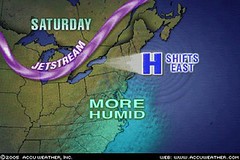
Weather map courtesy of Accuweather
In a recent post entitled Katrina´s Path, I explored the possibility of Katrina´s arrival over the Northeast as a fulfillment of the aforementioned forecast. There seems to be another possibility since Katrina won´t make it there within the forecast timeframe.
Conventional forecasters are now showing that a tropical air mass will move into the Northeast producing muggy conditions as far north as New England. A stalled cold front over New York will interact with this tropical air mass triggering showers and storms--some with heavy downpours.
Weather map courtesy of Accuweather
Thursday, August 25, 2005
Tropical Depression 9-E
The National Weather Service has issued its first forecast advisory on Tropical Depression 9-E. It is presently located at 106.3 West Longitude and 17.2 North Latitude. By August 27th, as can be seen from the map below, TD 9-E is forcast to move very near the coordinates mentioned in the Weather Alternative forecast for August 24-28, 2005. This forecast stated "The potential for tropical storm development is shown in and around 117 West Longitude and 20 North Latitude. This lies in the eastern Pacific about 560 miles southwest of the tip of Baja California." This forecast was prepared at the end of July 2005.
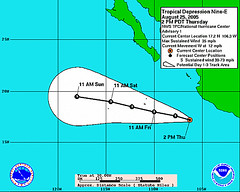
Weather map courtesy of the National Weather Service
Weather map courtesy of the National Weather Service
Katrina's Path?
Conventional forecasters are now toying with the possibility that Tropical Storm Katrina might make it to the Mid-Atlantic and Northeast in a few days. If this happens, it would be a fulfillment of the Weather Atlernative's forecast for Aug 24-28, 2005 that stated "The Northeast will experience a severe weather pattern that may be tropical in nature. One model shows a possible storm system off the coast of Virginia and North Carolina heading northward to the New York area." This forecast was prepared at the end of July 2005.
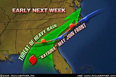
Weather grapic courtesy of Accuweather.
Weather grapic courtesy of Accuweather.
Monday, August 22, 2005
Scoreboard April-July 2005
Although no forecast method, be it conventional or alternative, can claim 100 percent accuracy, the Weather Alternative's system allows us to look much further into the future than today's conventional methods. How accurate have the Weather Alternative forecasts been so far? Here are some approximate scores for the long-range forecasts posted so far on this blog.
The Best and Worst of April's Weather: 82%
June 2005 Forecasts: 81%
July 2005 Mainland US: 64%
July 2005 Atlantic Hurricanes: 42%
July 2005 Pacific Hurricanes: 25%
July 2005Carribean Hurricanes: 50%
Forecast for the US mainland have been far more successful than hurricane predicitions for the open oceans due to more experience with North American weather patterns.
Wednesday, August 03, 2005
August 2005 Forecasts
These forecasts were prepared between July 22 and August 2, 2005.
August 4-5, 2005:
Showers are indicated over eastern Maine and Nova Scotia.
August 5-6, 2005:
Some unsettled weather is shown over the Great Basin area.
Warm and fair throughout the Mississippi Valley area.
Warm conditions that may break out in thunderstorms over New York State and surrounding area.
August 8-9, 2005:
Front setting off thunderstorms over the Pacific Northwest.
Possible tropical storm and/or hurricane formation over the Lesser Antilles (61 West/16 North)
August 9-11, 2005:
A stormy period is indicated for the Rockies. The weather pattern then continues over the Plains.
Storms are on the increase over New England.
August 12-14, 2005:
Windy conditions affect the Pacific Northwest as a front pushes through.
Breezy to windy conditions and most likely cooler temps affect the Great Basin and Rocky Mountains.
Windy weather is also shown for the Mid-Atlantic region through New England.
August 16-18, 2005:
Warmer conditions are shown for the Plains as a southerly airflow kicks in. If enough moisture is available, thunderstorms will ensue.
Rising temperatures over the Northeast and New England with the potential to trigger thunderstorms.
August 17-19, 2005:
A warm period is shown for the West Coast and Great Basin areas.
August 20-22, 2005:
Another stormy period is indicated for New England. There is a chance that this could be a tropical system.
August 24-28, 2005:
A strong cold front will enter the Pacific Northwest and set off storms as the front advances through the Great Basin area.
The potential for tropical storm development is shown in and around 117 West Longitude and 20 North Latitude. This lies in the eastern Pacific about 560 miles southwest of the tip of Baja California.
Tropical storm development is likely near 142 West Longitude and 18 North Latitude.
Texas and the Plains will see an active weather pattern at this time resulting in storms producing wind, hail, and possible tornadoes.
Moisture is also drawn up from the Gulf of Mexico over the Gulf Coast States of Louisiana, Mississippi, and Alabama. As the moisture surges northward toward the Central Mississippi Valley, storms will result.
A front through th Mid-Atlantic region will result in storms around the 26th.
The Northeast will experience a severe weather pattern that may be tropical in nature. One model shows a possible storm system off the coast of Virginia and North Carolina heading northward to the New York area.
Puerto Rico may find itself in the path of a tropical storm or hurricane as a number of indicators zero in on the area between 64-66 West Longitude and 17-18 North Latitude.
August 30-31, 2005:
A weather system will bring cool, dry air to the West Coast and Rockies. The same is indicated for the Plains. Fair and warm conditions are shown for the Mississippi Valley area.
Subscribe to:
Posts (Atom)