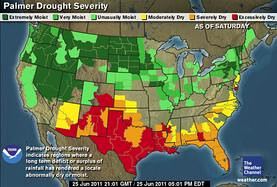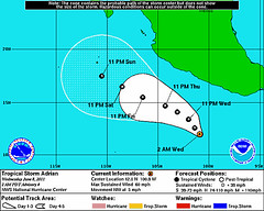
The long-range forecast posted on June 18th talked about how the astrometeorological effect of Venus would begin being felt around July 1st. Venus' influence was described as increasing the moisture content of the atmosphere accompanied by a southerly air flow and increasing temperatures.
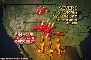
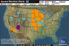
The mercury is starting to rise over the central U.S. with temperatures in some of these locations reaching between 100 to 110 degrees! Accuweather warns that the heat will continue for the next couple of days and be accompanied by high levels of humidity as well. As we progress into the forecast period, we'll look at how the rest of the forecast fared.
July 1-11 Long-range Weather Forecast
Hurricane Hot Spots for June 2011
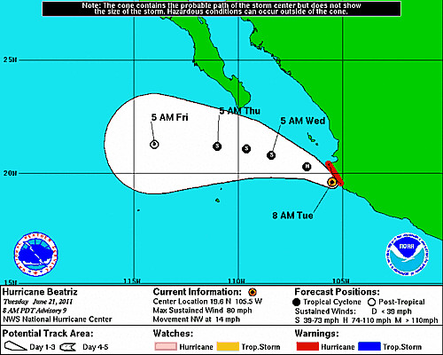
Hurricane Season 2011 Baja, Mexico
Hurricane Risk-Management
Hurricane Season 2011 Predictions
Overview of UK Winter 2012-13
The Winters of 2011-14
Cyclone Yasi fulfills long-range prediction!
Tropical Storm Matthew Fulfills Long-range Forecast!
Hurricane Earl and T.D. 10E Fulfill Long-range Forecasts!
Tropical Storm Alex Fulfills Long-range Prediction!
Bonnie Fulfills Long-range Forecast!
Introduction to the Weather Alternative
How Long-Range Forecasts Are Made
Excerpts from Tidal Dynamics by Fergus J. Wood
Big Dreamers
All successful people men and women are big dreamers. They imagine what their future could be, ideal in every respect, and then they work every day toward their distant vision, that goal or purpose. -- Brian Tracy