The Dell Horoscope long-range weather forecast that appeared in the August 2011 edition stated:
August 22-25
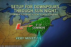
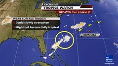
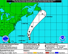
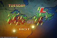
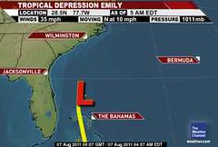
Tropical moisture still has access to the U.S. East Coast from the Carolinas northward. This time, however, there is an indication of a low pressure system about 200 miles off the North Carolina coast, which could be a tropical system.
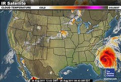
This is a great forecast in the sense that six months ago when I formulated the forecast (February 2011) the general time and area of this tropical system was obvious whereas conventional forecasters only began to see the potential around August 19th. The day before, conventional forecasters commented that it was too soon to determine what land areas would eventually be affected by the tropical wave that eventually would become Irene.
There is something I overlooked which could have made the forecast even more accurate since Hurricane Irene will be affecting the U.S. East Coast past the time frame I used. Mercury is turning direct today (26th) and as it does so it will make a ses-square aspect to Uranus. Normally, this would be considered a "minor" aspect, somewhat disruptive to weather patterns and usually pretty quick--a one day transit. Since Mercury, however, is slow in motion this aspect will linger for a couple of days and be triggered by the Moon's conjunction to Mercury tomorrow (Aug 27th). Under these circumstances a minor aspect by a fast moving planet now becomes a major aspect due to Mercury's slower-than-normal motion. Mercury-Uranus combinations are known for stormy and windy conditions.
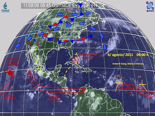
How does this tie in with Hurricane Irene? Well, the Solar Ingress chart for the summer season places Uranus over the U.S. Northeast and New England exactly where Irene will track during the next few days.
New Weather Alternative Website
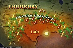
What About Rain For Texas?
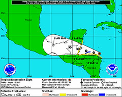
Tropical Storm Harvey Fulfills Long-range Weather Prediction!
General Weather Indications for August 2011
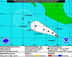
Hurricane Season 2011 Baja, Mexico
Hurricane Risk-Management
Hurricane Season 2011 Predictions
Overview of UK Winter 2012-13
The Winters of 2011-14
Fulfilled Long-range Forecasts for Hurricane Season 2010
Introduction to the Weather Alternative
How Long-Range Forecasts Are Made
Excerpts from Tidal Dynamics by Fergus J. Wood
August 22-25
Tropical moisture still has access to the U.S. East Coast from the Carolinas northward. This time, however, there is an indication of a low pressure system about 200 miles off the North Carolina coast, which could be a tropical system.
This is a great forecast in the sense that six months ago when I formulated the forecast (February 2011) the general time and area of this tropical system was obvious whereas conventional forecasters only began to see the potential around August 19th. The day before, conventional forecasters commented that it was too soon to determine what land areas would eventually be affected by the tropical wave that eventually would become Irene.
There is something I overlooked which could have made the forecast even more accurate since Hurricane Irene will be affecting the U.S. East Coast past the time frame I used. Mercury is turning direct today (26th) and as it does so it will make a ses-square aspect to Uranus. Normally, this would be considered a "minor" aspect, somewhat disruptive to weather patterns and usually pretty quick--a one day transit. Since Mercury, however, is slow in motion this aspect will linger for a couple of days and be triggered by the Moon's conjunction to Mercury tomorrow (Aug 27th). Under these circumstances a minor aspect by a fast moving planet now becomes a major aspect due to Mercury's slower-than-normal motion. Mercury-Uranus combinations are known for stormy and windy conditions.
How does this tie in with Hurricane Irene? Well, the Solar Ingress chart for the summer season places Uranus over the U.S. Northeast and New England exactly where Irene will track during the next few days.
New Weather Alternative Website
What About Rain For Texas?
Tropical Storm Harvey Fulfills Long-range Weather Prediction!
General Weather Indications for August 2011
Hurricane Season 2011 Baja, Mexico
Hurricane Risk-Management
Hurricane Season 2011 Predictions
Overview of UK Winter 2012-13
The Winters of 2011-14
Fulfilled Long-range Forecasts for Hurricane Season 2010
Introduction to the Weather Alternative
How Long-Range Forecasts Are Made
Excerpts from Tidal Dynamics by Fergus J. Wood