Friday, April 29, 2011

May 8-17, 2011

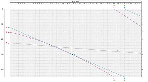
There's about a two week period in May where the planets Mercury and Venus are traveling side by side in close conjunction, which doesn't normally happen. The graph below gives an idea of this. Notice the two lines that run together from the left down the the lower right. At one point they cross a third line, which represents their conjunction to Jupiter. Let's see what weather these conjunctions might engender. I'll try and mention the most outstanding dates and places.
SFEphem

May 7-10, 2011
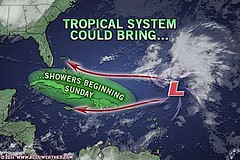
There is an indication that the tropics will begin to awaken at this time. It doesn't necessarily mean that a tropical system will result but there's a strong possibility that a low pressure system will develop now about 420 northeast of the Lesser Antilles.
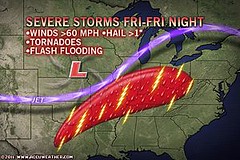
Another area that stands out for severe weather is the Texas and Oklahoma panhandles. Mercury and Venus together indicate increasing temperatures due to a moist, southerly airflow. This can indicate the ingredients necessary to trigger damaging thunderstorms, hail, and tornadoes. These storms could then continue in eastward transit toward the Mississippi Valley.

May 10-12, 2011
At this time the three planets, Mercury, Venus, and Jupiter all conjoin. A broad area in the west central Atlantic to the Lesser Antilles is activated now so we may continue to see low pressure areas that may be monitored for development.

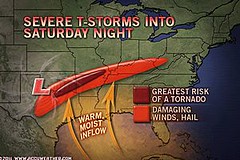
The Plains continues to be an area of concern as more warm, moist air will be available as a mechanism for thunderstorm generation. Storm potential is therefore greatly enhanced now.
The Full Moon and New Moon charts place these aspects over the West Coast States of California, Washington, and Oregon. Increasing heat and moisture could very well manifest as an increased monsoonal flow triggering storms over the area.
May 14-17, 2011
The West Coast States are still responding to increases in temperatures or at least warm, moist air masses. The area in and around Idaho is emphasized where storm development is a likely response.
Generally, the Plains through the Deep South and East Central States are experiencing an influx of warm, moist air from the Gulf which continues to provide the ingredients for storms.
A strong low pressure area seems likely to develop or strengthen about 475 miles northeast of the Lesser Antilles (around 54 west longitude and 19 north latitude).

untitled

Monday, April 25, 2011

April 18-24, 2011 Forecast Results

At the end of March, I posted a long-range forecast for April 18-24, 2011. The forecast zeroed in on areas that might experience "wild weather." Three areas were highlighted: Puerto Rico, the area from Northwest Texas through Tennessee and Georgia, and area about 600 miles off the coast of California.

21 Tropical
As can be seen from the above Accuweather map of April 21, conventional meteorologists were watching a low-pressure system about 460 northeast of San Juan, Puerto Rico. Forecasters were concerned that it might develop tropical characteristics. The low lingered in the area and by the 23rd, the National Weather Service issued its last advisory on the low pressure.

The next area for wild weather was from Northwest Texas through Tennessee and Georgia.
22 Texas Through Ohio
This was a very volatile time for this section of the States. Prior to the forecast period there were already deadly tornadoes. Within the April 18-24 window there were violent thunderstorms that hit central Texas to northern parts of Mississippi, Alabama and Georgia. There were reports of damaging winds and hail.

The above map is for the 22nd and shows the area slated for severe storms, tornadoes, and flash flooding. This is roughly the same area I pinpointed in my long-range forecast. The St. Louis airport was hit by a tornado.

23 Ohio Valley to Texas
The above Accuweather map is for the 23rd and shows roughly the same area that I had specified. Severe weather continued to threaten the area.
The 3rd area mentioned in the forecast was 600 miles off the coast of California. I was unable to verify either way if a low developed there or not.

Thursday, April 21, 2011

Tropical Activity

The Weather Alternative forecast posted on March 25, 2011 specified some "wild" weather likely to form around Puerto Rico between April 18-24, 2011. Check out the Accuweather map below that shows a low pressure area developing near Puerto Rico that may even develop tropical features.
21 Tropical

Here's what the National Weather Service is saying:

April 21, 2011
A LOW PRESSURE AREA LOCATED ABOUT 460 MILES NORTHEAST OF SAN JUAN
PUERTO RICO HAS DEVELOPED SOME SHOWER AND THUNDERSTORM ACTIVITY
NEAR ITS CENTER. IN ADDITION...SATELLITE DATA AND SHIP REPORTS
INDICATE GALE-FORCE WINDS ARE OCCURRING NORTH OF THE CENTER. SLOW
DEVELOPMENT OF THIS SYSTEM IS POSSIBLE DURING THE COUPLE OF DAYS AS
IT MOVES WEST-NORTHWESTWARD AT ABOUT 10 MPH. THERE IS A LOW
CHANCE...20 PERCENT...OF THIS SYSTEM DEVELOPING INTO A SUBTROPICAL
OR TROPICAL CYCLONE BEFORE CONDITIONS BECOME LESS FAVORABLE IN
ABOUT 48 HOURS.

In a few days we'll look at the results of the complete long-range forecast.

Hurricane Season 2011 Predictions

April 18-24, 2011 Severe Weather Window

Overview of UK Winter 2012-13

The Winters of 2011-14

Cyclone Yasi fulfills long-range prediction!

Tropical Storm Matthew Fulfills Long-range Forecast!

Hurricane Earl and T.D. 10E Fulfill Long-range Forecasts!

Tropical Storm Alex Fulfills Long-range Prediction!

Bonnie Fulfills Long-range Forecast!

Introduction to the Weather Alternative

How Long-Range Forecasts Are Made

Excerpts from Tidal Dynamics by Fergus J. Wood


easter

Friday, April 15, 2011

April 9-11, 2011 Forecast Results

The long-range forecast for April 9-11, 2011 was posted about a week beforehand on April 2nd. The forecast called for thunderstorms and severe weather over the New England area due to Pluto's retrograde station, Mars' square to Pluto and the Sun's conjunction to Mercury.
10 Northeast
The American Meteorological Society's Data Stream Atmosphere website reported the following for April 11th:


UNSETTLED WEATHER ACROSS THE NORTHEAST -- Two waves of precipitation moved across the Northeast on Monday. Early in the day, an area of rainshowers and thunderstorms traveled across sections of Upstate New York and New England. Early morning thunderstorms across New England produced quarter size hail along the Connecticut Valley in New Hampshire and in southern Maine. This precipitation was out ahead of a warm front that moved across the region. The warm front accompanied a storm that had moved into eastern Canada. This storm was responsible for Sunday's severe weather across sections of the upper Midwest.

Case For The Resurrection of Jesus

Wednesday, April 06, 2011

Hurricane Season 2011 Predictions

I'm proud to announce that Dell Horoscope magazine will carry my long-range weather forecasts for Hurricane Season 2011. The forecasts will appear in the August 2011 edition and cover the months of August through November.
image
Conventional forecasters are already predicting an active season but of course are not able to pinpoint specific dates and locations. Astro-meteorology can specify when and where hurricanes and severe weather patterns are likely to hit months or even years beforehand. If you click on some of the links below, you will see a number of tropical systems from last year's hurricane season that I predicted months or weeks beforehand.
Why Does Power Corrupt

Saturday, April 02, 2011

April 9-11, 2011 New England Forecast

The Mars-Pluto square of April 11, 2011 will be preceded by Pluto's retrograde station on the 9th and the Sun's conjunction to a retrograde Mercury that same day.
untitled
Pluto's retrograde station will usher in cold air over the New England area while the Mars-Pluto square will generate thunderstorm potential. Adding the gusty winds that usually accompany the conjunction of the Sun to a retrograde Mercury we have the recipe for some severe weather over the New England area.


April 18-24, 2011 Severe Weather Window

Overview of UK Winter 2012-13

The Winters of 2011-14

Cyclone Yasi fulfills long-range prediction!

Tropical Storm Matthew Fulfills Long-range Forecast!

Hurricane Earl and T.D. 10E Fulfill Long-range Forecasts!

Tropical Storm Alex Fulfills Long-range Prediction!

Bonnie Fulfills Long-range Forecast!

Introduction to the Weather Alternative

How Long-Range Forecasts Are Made

Excerpts from Tidal Dynamics by Fergus J. Wood

Monkey Business