
Work is under way on long-range weather forecasts for Hurricane Season 2006. This will take awhile before they are posted.
Another project to be posted is the forecast results of The Weather Alternative forecasts for October and November 2005.
Work is under way on long-range weather forecasts for Hurricane Season 2006. This will take awhile before they are posted.
Another project to be posted is the forecast results of The Weather Alternative forecasts for October and November 2005.

Click here for November Forecasts.
Graphics courtesy of Accuweather.com
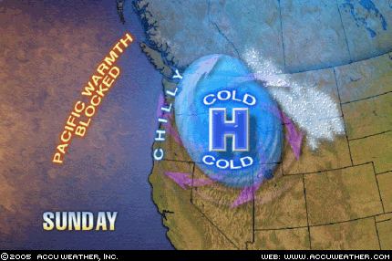
Conventional forecasters are saying that the blizzard affecting the Northern Plains with over a foot of snow and sustained winds of 40 mph and gusts up to 60 mph will go down is history as the Great Plains Blizzard of 2005.
The Weather Alternative posted the following forecast on September 9, 2005:
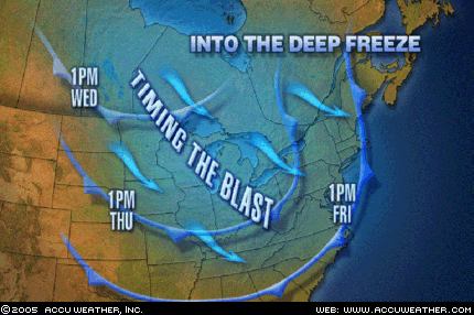
November 27-29, 2005:
Forecast: Increasing wind speeds and falling temperatures will be the story from the western Great Lakes, across the Mississippi Valley, and eastward as cold Canadian air pushes southward. This weather pattern will extend across the eastern Great Lakes and into the Mid-Atlantic area etc...
Click here for November Forecasts
Weather Graphic courtesy of Accuweather.
This Weather Alternative forecast was posted on September 9th, over 2 months ago.
November 27-29, 2005:
Forecast: A cool high pressure area will enter the West Coast. This drier air mass may ignite some storms and windy conditions in its attempt to establish itself over the region.
The Weather Channel reports that "strong, gusty winds are expected to gallop over the Southwest—especially the higher elevations—and the southern Great Basin. Strong Santa Ana winds are likely tonight and early tomorrow in Southern California."
The National Weather Service has issued a frost adivsory for parts of California:
NATIONAL WEATHER SERVICE
HANFORD CA
636 PM PST SAT NOV 26 2005
...FROST ADVISORY ISSUED FOR THE CENTRAL AND SOUTHERN
SAN JOAQUIN VALLEY FOR TONIGHT....A COLD AND DRY AIRMASS...ALONG WITH LIGHT WINDS AND CLEARSKIES...OVER THE CENTRAL AND SOUTHERN SAN JOAQUIN VALLEY WILL ALLOW TEMPERATURES TO DROP TO NEAR FREEZING BY EARLY
SUNDAY MORNING.
Click here for November Forecasts.
Graphics courtesy of Accuweather.com
Here's another Weather Alternative forecast that was posted back on September 9, 2005:
November 21-24, 2005:
Forecast: This promises to be a very active period for the Plains. The necessary ingredients to produce blizzard-like conditions seem to be present over the Northern Tier States.
The National Weather Service has issued Winter Storm warnings for the Great Lakes area.
URGENT - WINTER WEATHER MESSAGE
NATIONAL WEATHER SERVICE
MARQUETTE MI 519 PM EST TUE NOV 22 2005
...DANGEROUS WINTER STORM FOR THE THANKSGIVING HOLIDAY...
.LOW PRESSURE MOVING INTO THE UPPER GREAT LAKES WEDNESDAY WILL INTENSIFY AS IT MOVES SOUTHEAST INTO THE CENTRAL GREAT LAKES WEDNESDAY NIGHT. BEHIND THE LOW PRESSURE...A BLAST OF ARCTIC AIR WILL SURGE ACROSS LAKE SUPERIOR...GENERATING HEAVY LAKE EFFECT SNOWSHOWERS ACROSS UPPER MICHIGAN WEDNESDAY NIGHT THROUGH THURSDAYNIGHT. VERY STRONG NORTHERLY WINDS WILL CREATE BLIZZARD CONDITIONS NEAR LAKE SUPERIOR WEDNESDAY NIGHT THROUGH THE THANKSGIVINGHOLIDAY.
Click here for November Forecasts
Graphics courtesy of Accuweather.com
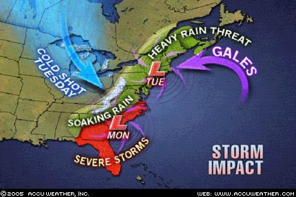
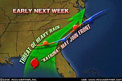
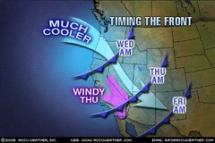
As shown above, conventional forecasters are predicting a major East Coast storm Monday and Tuesday, November 21-22, 2005.
Accuweather states "Adverse weather with the big East Coast storm will begin in the Southeast late Sunday and early Monday before spreading quickly through the Eastern Seaboard to New York and New England Monday through early Tuesday... Much of Florida and Georgia through the coastal plain of the Carolinas and southeastern Virginia will have a threat of severe local thunderstorms, including hail, high winds and even isolated tornadoes... Another factor will be that of high winds, especially coastal winds, as the storm spins up dramatically late Monday through Tuesday. New England will bear the brunt of coastal winds along with tide and wave action, but there will be strong winds well inland at this time too. As if these were not enough, there will be a wintry side to the storm, too. Cold air will pour into the Midwest Monday night and Tuesday.
(Bold print added by The Weather Alternative)
On September 9th of this year, The Weather Alternative posted forecasts for November 2005. The East Coast storm and the cold air entering the Midwest were mentioned in these forecasts although the timing seems to be a day or so off.
For example, the cold air to pour into the Midwest on the 21st and 22nd was mentioned in the November 19-20 forecast:
"Another bout of blustery weather and lower temperatures is shown for the Mississippi Valley and Eastern U.S. "
The East Coast storm scheduled for Monday and Tuesday November 21-22 was specified in The Weather Alternative forecast for November 23-24:
"The clash between high and low pressure systems will focus on the coastal areas of Virginia and North Carolina. High winds or severe storms are likely to hit this area. This may be part of a larger weather pattern that affects the Mid-Atlantic area."
Click here for November Forecasts.
Here are some updates on The Weather Alternative's November Forecasts. These were prepared between August 21, 2005 and September 6, 2005.
November 12-15, 2005:
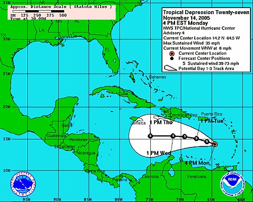
Forecast: It seems that a tropical weather system, be it a tropical wave, storm etc., or other severe weather pattern will affect Hispañola.
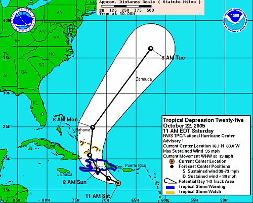
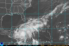
As can be seen from the above map, Tropical Depression 27 (soon to be upgraded to Tropical Storm Gamma) is forecast to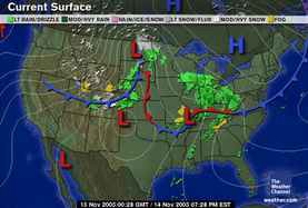 pass close to Hispañola over the next few days.
Another Weather Alternative forecast that's shaping up is the following:
November 14-17, 2005:
Forecast: The incursion of colder air over the eastern half of the country and consequent tumbling temperatures will necessitate frost and freeze advisories over the region. The 16th and 17th appear to be high points when cold air and windy conditions will manifest over the Mississippi Valley area.
The Weather Channel reports the following:
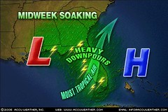
A strong cold front will smash into the South tomorrow, and with it, some very dangerous weather. While scattered showers and storms will speckle much of the South, nasty thunderstorms with the potential for damaging winds and violent tornadoes will sweep eastward from the eastern parts of Oklahoma and Texas across the Mississippi Valley during the daylight hours and on eastward during the evening. At highest risk for potentially deadly storms are eastern Arkansas, western Tennessee, northern Mississippi and northwest Alabama. Behind the front, gusty winds will hurl colder air southward toward the Texas Gulf Coast and eastward into the lower Mississippi Valley.
Click here for November Forecasts
The Weather Alternative forecasts for November 2005 were prepared between August 21, 2005 and September 6, 2005.
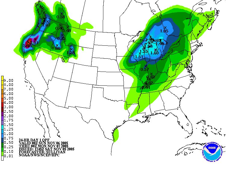
Here's an update on two forecasts for November 5-7, 2005.
Forecast: Another round of storms batters the West Coast States. Moist, warm air finds its way over the region producing "caffeinated" storms over the Intermountain West.
Today the Weather Channel reported "Another Pacific storm will take aim on the Pacific Northwest today resulting in increasing winds, rain and snow. This system is the latest, in a series of storms, to batter the Pacific Northwest and this trend will continue next week. A flood watch in effect for today and through much of Sunday for northwestern Oregon including the Willamette Valley."
Forecast: As warm, moist air is funneled northward over the Plains, colder, drier air rushes southward over the Mississippi Valley. The inevitable result is that storms will erupt over both these areas as the colder air collides with this southerly invasion. Watch, in particular, for strong storms over the Arrowhead of Minnesota. Gusty winds usually accompany this pattern.
Today Accuweather related the following: "Cold air blasting in from the northern Plains is colliding with warm, moist air from the South, creating an explosive, fast-moving band of thunderstorms that will pummel the Midwest and parts of the Great Lakes today. The region will experience a line of strong storms with high winds, locally heavy rainfall, and possibility of hail. Scattered power outages are possible due to the high winds and damage caused by the storms."
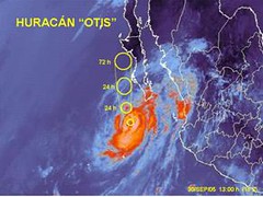
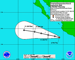
MSNBC reported today that "Hurricane Wilma triggered mudslides that killed up to 10 people in Haiti as the season’s record-tying 21st storm strengthened rapidly on Tuesday and headed for the Gulf of Mexico on a path toward storm-weary Florida."
Conventional forecasters foresee Wilma hitting southern or central Florida by this weekend. This Saturday, the 22nd, shows important planetary alignements between the Sun and Jupiter, and Mercury and Mars. The recent Lunar Eclipse of October 17th focuses some of these energies over the Florida Panhandle. This may be an indication where Wilma will make landfall.
July 21, 2005: (The Weather Channel)
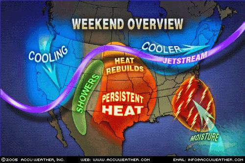
Midwest
The heat continues to expand across the Midwest with St.Louis under an excessive heat warning into the weekend. High temperatures in the 100s will be common across the Central Plains with the Upper Midwest sitting comfortably in the 70s and 80s. The threat for scattered t-storms will exist across the northerh half of the Midwest into the weekend as a front will traverse across the northern tier of the U.S.
July 22, 2005: (The Weather Channel)
Midwest
High temperatures will eclipse 100 degrees on Saturday from Illinois, South Dakota and down to Kansas and Oklahoma on Saturday. Highs in the 90s will surround this area of 100s. With plenty of humidity, afternoon heat indices could top 110 degrees in the mid-Mississippi Valley along the Missouri-Illinois line Saturday and Sunday. Numerous heat advisories and excessive heat warnings/watches will continue for parts of the Ohio Valley, mid-Mississippi Valley, and Central Plains.
July 23, 2005: (The Weather Channel)
Afternoon heat indices in the lower Missouri, mid-Mississippi and lower Ohio Valleys may again top 115 degrees. This heat is potentially deadly and heat advisories and excessive heat warnings remain in effect.
Forecast
July 31-Aug 1, 2005:
This will more than likely be a stormy period for the Southeast and Mid-Atlantic States as conflicting atmospheric currents produce severe disturbances. The New England area will also be targeted by severe weather, which may be a tropical system.
Results
July 30, 2005: (The Weather Channel)
South
Scattered showers and thunderstorms will once again speckle much of the South tomorrow, mainly east of the Mississippi River, as a sticky subtropical air mass stands its ground.
NortheastThe generally pleasant weather gracing much of the Northeast north of the Mason-Dixon Line today will be replaced by the threat of a few showers and thunderstorms tomorrow.
July 31, 2005: (The Weather Channel)
South
More of the same for the South Monday: the Southeast will see scattered showers and thunderstorms...
Northeast
A weak disturbance aloft and a weak cold front dipping southward into New York and New England will set off a few showers and thunderstorms in the Northeast Monday...
August 1, 2005: (The Weather Channel)SouthNothing much will change across the Southeast on Tuesday as conditions will be warm and humid. Showers and thunderstorms will dot the landscape...
NortheastTemperatures will feel more like the dog days of August over the next couple of days through the Northeast...
August 2, 2005: (National Weather Service)
The NWS reported that Tropical Depression 8 formed 565 miles southwest of Bermuda. (68.7 West/28.5N)
Atlantic
Forecast
July 9-13, 2005:
The broad area between 41-55 West Longitude and 15-18 North Latitude shows potential for tropical storm and/or hurricane development.The “hottest” longitudes appear to be 44, 51 and 55 West. Potential is also shown around 41 West/21 North, and around 45 West/8 North.
Results
July 10, 2005 (National Weather Service)
...FIFTH TROPICAL DEPRESSION OF THE SEASON DEVELOPS OVER THECENTRAL TROPICAL ATLANTIC OCEAN...
AT 11 PM AST...0300Z...THE CENTER OF TROPICAL DEPRESSION FIVE WASLOCATED NEAR LATITUDE 10.8 NORTH... LONGITUDE 42.9 WEST OR ABOUT1280 MILES...2055 KM... EAST-SOUTHEAST OF THE LESSER ANTILLES.
MAXIMUM SUSTAINED WINDS ARE NEAR 30 MPH... 45 KM/HR...WITH HIGHERGUSTS. SOME GRADUAL STRENGTHENING IS FORECAST DURING THE NEXT 24HOURS AND THE DEPRESSION COULD BECOME A TROPICAL STORM ON MONDAY.
Forecast
July 10-13, 2005:
The central Atlantic around 35 West Longitude and 18 North Latitude shows potential for tropical storm and/or hurricane formation.
Results
July 11, 2005: (National Weather Service)CENTRAL CARIBBEAN TROPICAL WAVE IS ALONG 33W SOUTH OF 15N MOVING WEST 10 TO 15 KT. CURRENT SATELLITE IMAGERY SHOWS A WELL DEFINED WAVE. SCATTERED MODERATE/ISOLATED STRONG CONVECTION EXTENDS FROM 5N-9N BETWEEN 30W-37W.
July 12, 2005: (NWS)CENTRAL ATLC TROPICAL WAVE IS ALONG 37W S OF 16N. THE SYSTEM IS MOVING W NEAR 10 KT. ISOLATED MODERATE/CONVECTION FROM 7N-11N BETWEEN 34W-39W.
July 14, 2005: (National Weather Service)TROPICAL WAVE IS ALONG 38W/39W S OF 21N WITH A 1011 MB LOW ALONG THE WAVE NEAR 15N. THE SYSTEM IS MOVING W NEAR 10-15 KT. SCATTERED MODERATE/ISOLATED STRONG CONVECTION IS N OF THE LOW WITHIN 60/75 NM OF 17N FROM 37W-41W.
Forecast
July 14, 2005:
Look for Tropical Storm development off the west coast of Africa around 20 West Longitude and 10 North Latitude.
Results
July 14, 2005: (National Weather Service)TROPICAL WAVE WAS INTRODUCED ALONG 21W S OF 19N AT 0600 UTC BASED ON SATELLITE PRESENTATION. THE WAVE IS MOVING W 10 KT. BROAD MID/UPPER LEVEL CYCLONIC FLOW IS OBSERVED ON INFRARED AND VISIBLE SATELLITE IMAGERY. SCATTERED MODERATE/ISOLATED STRONG CONVECTION IS N OF THE ITCZ AXIS WITHIN 60 NM OF LINE 10N22W- 11N24W-10N26W.
Forecast
July 19-20, 2005:
Tropical Storm and/or Hurricane formation between 39-42 West Latitude and 20 North Longitude.
Results
July 19, 2005: (National Weather Service)
EAST ATLANTIC TROPICAL WAVE ALONG 37W/38W S OF 19N MOVING W 10-15 KT. THE WAVE EXHIBITS A SHARP INVERTED-V SIGNATURE WITH A LOW-LEVEL CIRCULATION CENTER NEAR 13N37.5W. THE WAVE IS BEING OVERTAKEN BY A SURGE OF DRY SAHARAN AIR AND SUSPENDED DUST E OF 34W WHICH IS MAKING THE ENVIRONMENT UNFAVORABLE FOR DEEP CONVECTION. HOWEVER...LOW STRATUS HAS BEEN INCREASING NEAR THE AXIS AND LIGHT SHOWERS ARE POSSIBLE FROM 12N-22N BETWEEN 34W-44W.
Forecast
July 22, 2005:
Tropical Storm and/or Hurricane formation around 23 West Longitude and 11 North Latitude and 43 West which seems to back July 19-20 indications.A cold front may develop off the East Coast of the U.S. running the length of coast.
Also check 48 West Longitude and 11 North Latitude for Tropical Storm development.
Results
July 23, 2005: (National Weather Service)
TROPICAL WAVE INTRODUCED BETWEEN THE AFRICAN COAST AND CAPE VERDE ISLANDS ALONG 20W S OF 16N MOVING W 10-15 KT.
CENTRAL ATLANTIC TROPICAL WAVE ALONG 44W/45W S OF 22N MOVING W 15-20 KT WITH A 1011 MB LOW ALONG THE AXIS NEAR 11N45W.
Forecast
July 31-Aug 2, 2005:
The following places show potential for Tropical Storm and/or Hurricane development:
51 West Longitude and 10 North Latitude
44 West Longitude and 10 North Latitude
29 West Longitude and 8 North Latitude (maybe 21 North too)
35 West Longitude and 19 North Latitude
Results
July 31, 2005: (National Weather Service)
TROPICAL WAVE IS ALONG 50W S OF 19N MOVING WEST 17 KT.
SCATTERED MODERATE CONVECTION IS SEEN FROM 5N-8N BETWEEN 36W-39W. ISOLATED MODERATE CONVECTION IS WITHIN 9 0NM EITHER SIDE OF THE ITCZ BETWEEN 28W-36W.
August 2, 2005: (National Weather Service)FAR E ATLC TROPICAL WAVE IS ALONG 28W S OF 17N MOVING W 10 KT.
Pacific
Potential for Tropical Storm and/or Hurricane formation is indicated for the follwing places around the dates indicated:
Forecast
July 5, 2005:
Around 154W/24N or North of Big Island, Hawaii.
Results
No tropical system reported.
Forecast
July 9-13, 2005:
145 through 149 West Longitude around 16 North Latitude.
Results
No tropical systems reported.
Forecast
July 10-13, 2005:
127 West Longitude and 7 North Latitude.
Results
July 10, 2005: (National Weather Service)TROPICAL WAVE ALONG 124W FROM 5N TO 15N AND IS MOVING W AT 15 KT. SCATTERED MODERATE ISOLATED STRONG CONVECTION IS MAINLY E OF THE WAVE AXIS AND WITHIN 120-150 NM OF THE ITCZ.July 11, 2005: (NWS)TROPICAL WAVE IS ALONG 127W/128W FROM 7N TO 15N AND IS MOVING W AT 10 KT. ONLY ISOLATED MODERATE CONVECTION IS OCCURRING WITHIN 120 NM E OF THE WAVE AXIS.
Forecast
July 13, 2005:
131 West Longitude and 21 North Latitude. This may be related to the July 10-13 forecast.
Results
July 12, 2005: (National Weather Service)TROPICAL WAVE IS ALONG 133W FROM 8N TO 15N AND IS MOVING W AT 10 KT. LITTLE CONVECTION IS ASSOCIATED WITH THIS SYSTEM.
Forecast
July 22, 2005:
141 West Longitude and 11 North Latitude.
141 West Longitude and 38 North Latitude is highlighted for storm activity. This, however, is to far north to be tropical in nature.
Results
July 23, 2005: (National Weather Service)
A LONG WAVE UPPER TROUGH DOMINATES THE UPPER LEVELS OF THE E PACIFIC WITH MEAN AXIS ALONG 36N142W THROUGH AN UPPER CYCLONE AT 33N148W WITH THE TROUGH CONTINUING SW TO BASE AT 20N154W.
Forecast
July 31-Aug 2, 2005:
129 West Longitude and 12 North Latitude
146 West Longitude
Results
ResultsJuly 31, 2005: (National Weather Service)
TROPICAL WAVE ALONG 125W MOVE W 15 KT. BROAD CYCLONIC CIRCULATION FROM 10N TO 15N BETWEEN 120W AND 127W.
August 2, 2005: (National Weather Service)
An area of cloudiness and scattered thunderstorms is about 880 miles southeast of the Big Island of Hawaii. The thunderstorms continue to remain disorganized...(aprox. 145W/11N)
Caribbean
Forecast
July 10-11, 2005:
80 West Longitude and 13 North Latitude, which lies off coast of Nicaragua.
Results
July 10, 2005: (National Weather Service)CLUSTERS OF SCATTERED MODERATE TO STRONG CONVECTION IS INLANDOVER CENTRAL AMERICA FROM NICARAGUA TO S MEXICO BETWEEN84W-93W.
July 11, 2005: (National Weather Service)THE UPPER LOW OVER THE CENTRAL CARIBBEAN ALONG WITH THE TROPICAL WAVE IS ENHANCING THE GENERATION OF CONVECTION OVER CUBA AND JAMAICA AS WELL AS NUMEROUS MODERATE/ ISOLATED STRONG CONVECTION FROM 7N-15N BETWEEN 81W-87W ALONG HONDURAS...NICARAGUA...COSTA RICA AND PANAMA.
Forecast
July 23-26, 2005:
79 West Longitude and 20 North Latitude. This lies off the south central coast of Cuba.
Results
July 24, 2005: (National Weather Service)CENTRAL CARIBBEAN TROPICAL WAVE IS ALONG 75W/76W S OF 20N MOVING W 15-20 KT. THIS WAVE MARKS THE LEADING EDGE OF THE AFRICAN DUST SURGE...BUT THE CONCENTRATIONS APPEAR THINER AS IT MOVES ACROSS THE CARIBBEAN. SCATTERED MODERATE/STRONG CONVECTION IS W OF THE WAVE AXIS S OF 11N FROM 76W-78.5W TO INLAND OVER N COLOMBIA AND THE COAST OF PANAMA.
Forecast
July 31, 2005:
74 West Longitude and 12 North Latitude, which lies off the northern coast of Colombia.
Results
July 30, 2005: (National Weather Service)
A WELL-DEFINED TROPICAL WAVE IS LOCATED OVER THE CENTRAL CARIBBEAN AND SW ATLANTIC ALONG FROM 12N72W TO 23N68W MOVING WEST 15-20 KT...