Tuesday, May 31, 2011

Hurricane Hot Spots June 2011

The following long-range weather forecasts reveal some dates and places worth watching for tropical activity and other forms of severe weather. The slower moving planets can have a major impact on the weather as they align in important configurations. During June of this year, Uranus and Pluto will be only 2 degrees shy of an exact square. The square or 90 degree aspect between planets in astrometeorology brings low pressure systems and disruptive atmospheric conditions.
map_caribbean

June 17-20
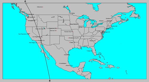
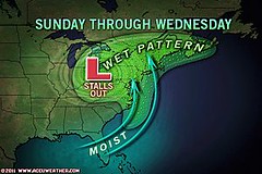
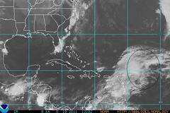
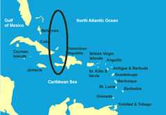
On the 18th and 19th of June, Mercury will trigger this square by squaring Uranus and then opposing Pluto. One of the areas vulnerable to their influence is just east of the Bahamas and southward through Haiti. This is an area that has the potential to develop a tropical system or some type of severe weather pattern. New England is another area, which most likely will experience a severe weather pattern of its own.

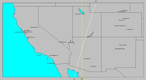
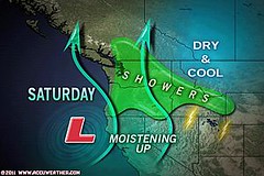
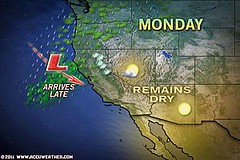
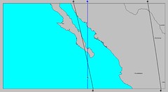
The Baja California also stands out as an area where tropical storm or severe weather conditions may develop. Since I'm already expecting a low pressure or tropical system around June 21-23, this may be a build up of that. The Rockies appear to be affected by a strong front or low pressure system at this time as well.
baja

June 20-23
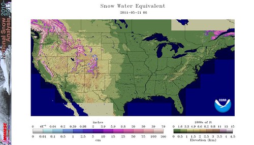
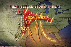
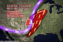
Mercury will square Saturn on the 21st and Mars will square Neptune on the 22nd. One area that stands out for possible tropical storm development is around 67 west longitude and 25 north latitude. This is roughly 550 miles east of the Bahamas and 430 miles north of Puerto Rico. This may be the same system mentioned in the above June 17-20 forecast or an independent one. The Rockies are also highlighted again for severe weather conditions in the form of a front or storm system. This could be a time when the melting snowpack brings flooding conditions to the area.

Gas Prices

Thursday, May 26, 2011

June 2011: Long-range Weather Forecasts

Johannes Kepler, the discoverer of the planetary laws of motion, developed a long-range weather forecast system based on planetary cycles. His success as a long-range weather forecaster or astro-meteorologist preceded his success as the discoverer of the laws of motion. Here are some forecasts for June based on his system.
Southwest

On June 3rd, Mercury will square Neptune. The square or 90 degree aspect is a storm-breeding relationship between two planets. On the same day, Neptune will begin its retrograde motion. This means that from our viewpoint on earth, Neptune will appear to move backwards in the heavens. The retrograde motion of Neptune has been observed to coincide with excessive humidity and abundant moisture.

Key charts used in making astro-meteorological forecasts show the influence of Mercury and Neptune over the western U.S., the Baja Peninsula, and the area around Guadalajara, Mexico. The above astro-locality map shows the area in and around Arizona to be particularly affected by Neptune's pluvial influence. In my experience, the effects of a retrograde planet build up over the days after it begins its retrograde motion. I think the period between June 3rd and 7th should show that the above mentioned areas will receive an influx of moisture due to low pressure systems or fronts. The Guadalajara area and the Baja could see a tropical system affecting them since the eastern Pacific is now in hurricane season or it could be some other type of severe weather pattern. The Arizona area may see an increased monsoonal flow triggering abundant moisture at this time.

The-Planet-Saturn

On June 12th, Saturn will also change its apparent motion after about 4 1/2 months of its backward boogie. Saturn will now appear to move forward in the heavens. This change of motion has been observed to correspond to cold and damp conditions. When coupled with the Sun's conjunction to Mercury on the same day, which can excite windy conditions, these can all work together to bring noticeable weather patterns.

Astro-locality maps draw our attention to a number of places. One place where the Sun, Mercury, and Saturn join forces is in and around the Texas and Oklahoma panhandles up through Nebraska. One possibility is that a strong low pressure system is ejected out of the Rockies into the central Plains bringing severe weather in eastward transit to the Mississippi Valley area. Our time frame is roughly between the 12th and the 16th.

Another area that might be worth watching from around the 10th through the 14th is the Gulf of Mexico. The area just north of the Yucatan Peninsula (around 89W/23N) over to western Cuba and northward to the Central Gulf Coast may show signs of tropical activity.

Neptune and Rockies Flood Potential

Hurricane Season 2011 Baja, Mexico

Hurricane Risk-Management

Hurricane Season 2011 Predictions

Overview of UK Winter 2012-13

The Winters of 2011-14

Cyclone Yasi fulfills long-range prediction!

Tropical Storm Matthew Fulfills Long-range Forecast!

Hurricane Earl and T.D. 10E Fulfill Long-range Forecasts!

Tropical Storm Alex Fulfills Long-range Prediction!

Bonnie Fulfills Long-range Forecast!

Introduction to the Weather Alternative

How Long-Range Forecasts Are Made

Excerpts from Tidal Dynamics by Fergus J. Wood


Alister McGrath on Science and the New Atheism

Saturday, May 21, 2011

Neptune and Rockies Flood Potential

Conventional weather forecasters are concerned that the snowpack that has accumulated in the northern and central Rockies, Cascades, and Sierra Nevada due to a long-running winter with deep snowfall may mean downstream flooding for those areas when warmer conditions melt the snowpack. The light pink and white areas on the map below depict snow water content over 30 inches. Image appears courtesy of NOAA.
nsm_swe_2011052105_National
A great deal of the snowpack is still intact due to unseasonably cool conditions and with the combination of cool, wet weather, more snow continues to fall. Some meteorologists, however, are forecasting above-normal warmth through the Rockies during the month of June. A rapid thaw could lead to dangerous flooding.

According to astro-meteorology, which ventures long-range forecasts based on planetary cycles, the influence of the planet Neptune affects the western United States during the spring season as shown on the map below.

Melt
Some of the effects of Neptune on weather conditions due to its connection with southerly airflows according to the late George J. McCormack are thaws and snow slides in mountain areas. Times when this influence is activated should be when Neptune is aspected by other planets. Here are some approximate dates to watch for.
May 22nd- Sun square Neptune
June 3rd- Mercury square Neptune
June 8th- Jupiter sextile Neptune
June 10th- Venus square Neptune
June 16th- Mercury trine Neptune

End

Wednesday, May 18, 2011

May 8-17, 2011 Forecast Results

The close conjunction of Mercury and Venus throughout the May 8-17 period was the basis of the long-range forecast posted on April 29th. There were basically three areas that were emphasized: the Plains, the western Atlantic, and the West Coast.

The Plains
The first portion of the forecast for the Plains spoke of increasing temperatures due to a moist, southerly airflow and the possibility of damaging thunderstorms, hail, and tornadoes. The areas to be affected were the Texas and Oklahoma panhandles and eastward toward the Mississippi Valley.

The first Accuweather map shows the severe thunderstorm threat for the 8th through the 10th over Texas and Oklahoma and continuing toward the Mississippi River Valley.
06 Next Week
The next Accuweather map for the 9th confirms the increasing temperatures and moisture talked about in the forecast.

09 Record heat
Greatly enhanced storm potential was the forecast for the Plains during the May 10-12 period.
This next map for the 11th shows the area slated for tornadoes, large hail, and severe thunderstorms.

10 Heartland
The forecast for the final period, May 14-17, specified through the Plains, Deep South, and East Central States. This next map shows the lingering low pressure area affecting the East Central and Northeast States from the 15th through the 18th.
15 Northeast

The Western Atlantic
The forecast for the whole period mostly concentrated on an area roughly 420 to 475 miles northeast of the Lesser Antilles centering around 54 west longitude and 19 north latitude, and looked for a low pressure system (not necessarily tropical) that would affect the area. A strong low was forecast to develop between the 14th through the 17th.

The National Weather Service made the following comments throughout the period:
May 9: Low-level moisture continues to pool along a surface trough from 18N55W into the NE Caribbean...
May 11: A SURFACE TROUGH IS OVER THE W TROPICAL ATLC INTO THE NE CARIBBEAN EXTENDING FROM 21N55W ACROSS THE VIRGIN ISLANDS NEAR 18N63W.
May 15: ANOTHER LOW PRESSURE SYSTEM IS IMPACTING THE CENTRAL ATLC. AN UPPER LEVEL TROUGH IS ALONG 53W...

The following weather map is for May 15 and shows the area mentioned.

15 Tropics
This low pressure area around May 15th was broad enough that it affected Puerto Rico and the Virgin Islands with strong storms. Accuweather reported "More Drenching Storms for Puerto Rico, Virgin Islands. Drenching showers and thunderstorms will continue to soak the northeastern Caribbean Islands through at least early next week..."

West Coast
Between the 10th and the 17th, the West Coast was forecast to experience an increase in heat and moisture leading to storms over California, Washington, Oregon, and Idaho.

On the 14th, a low pressure area hit the West Coast States of Washington, Oregon, and Idaho as shown in the following Accuweather map. Their title was "Storm to Slam West Coast this Weekend."
13 West Coast

On the 16th, Accuweather reported "The next shot of rain will advance onshore over northern California later today. " Here's their weather graphic.

16 West


If Evolution Were Really True, It Would Look Like This...

img119

Saturday, May 14, 2011

Hurricane Season 2011 Baja, Mexico

The map below shows the planetary influences at work over the Baja California at the time of the summer solstice. The summer solstice chart is used by astro-meteorologists to assess weather patterns for the summer season and issue long-range weather forecasts.
Baja
This map for the summer of 2011 in particular is of interest because of the planetary influences that concentrate over the Baja California. The two crossing lines represent the influences of Mars and Neptune. In addition to their crossing, the two planets are in a 90 degree relationship which indicates a distruptive influence on weather patterns.

Neptune's influence on the weather correlates with tropical moisture, high humidity, and heavy downpours. Mars adds energy to weather patterns through heat. Together this planetary combination can indicate low pressure areas that bring strong storms and heavy rainfall. Tropical storms and hurricanes fit this description as well.

Vacationers considering the Baja California as their destination this year should note the following dates as times when low pressure areas and/or tropical systems could threaten the area. My Hurricane Season 2011 forecasts will appear in the August edition of Dell Horoscope.

June 21-23, 2011
This is when the summer solstice chart takes effect and the square or 90 degree aspect between Mars and Neptune makes their initial contact.

July 29-31, 2011
Mercury triggers the Mars-Neptune set up now. This has the potential to result in a low pressure that generates strong winds and rain.

August 5-8, 2011
Mercury retrograde, itself an indication of windy conditions, triggers Mars-Neptune again bringing the potential a tropical system.

August 20-25, 2011
Conditions are now conducive for a low pressure system to form over the area as Venus triggers Mars and Neptune.

September 7-10, 2011
Mercury once again enters the equation and brings the possibility of a low pressure area or tropical system over the Baja.

May 8-17, 2011 Forecast

Hurricane Risk-Management

Hurricane Season 2011 Predictions

Overview of UK Winter 2012-13

The Winters of 2011-14

Cyclone Yasi fulfills long-range prediction!

Tropical Storm Matthew Fulfills Long-range Forecast!

Hurricane Earl and T.D. 10E Fulfill Long-range Forecasts!

Tropical Storm Alex Fulfills Long-range Prediction!

Bonnie Fulfills Long-range Forecast!

Introduction to the Weather Alternative

How Long-Range Forecasts Are Made

Alister McGrath on Faith and the New Atheism

Friday, May 06, 2011

Hurricane Risk-Management

As of April 2011 Colorado State University, Weather Service International, and Tropical Storm Risk have lowered the number of hurricanes they're expecting in the Atlantic Basin for the 2011 season. Nevertheless, they all agree the season should be well above average. CSU expects 16 named storms and 9 hurricanes while Weather Service International foresees a more impactful season along the U.S. coastline. They estimate 15 named storms and 8 hurricanes. Tropical Storm Risk calls for 14 named storms and 7 to 8 hurricanes. They realize that it is, of course, impossible to precisely predict this or any season's hurricane activity in early April.

hurricane

Because a land-falling hurricane can cause extensive damage, risk management experts work with models that are designed to estimate insured losses due to these tricky tropical tempests. What has presented even more of a problem for these experts is trying to anticipate where and how many hurricanes will make landfall. The three major catastrophe modelers, AIR Worldwide, EQECAT, and Risk Management Solutions (RMS) have recently concluded that their near term hurricane models have significantly overestimated losses due to land-falling hurricanes. For example, they initially projected insured loss levels for the 2006-2010 period at 35 percent above the long-term average. The actual cumulative losses, however, were less than one third of the long-term cumulative average.

global_running_ace

Here's where the Hurricane Frequency Paradox comes into play which states that although there has been an increase in Atlantic tropical activity since the 19th century, there has not been an increase in hurricane landfalls for the United States. The answer may be due to improved observational techniques according to NOAA researchers. For example, in the days before satellite technology, some tropical systems that formed and died out at sea went undetected. Now they are tallied up with each season's hurricanes if and when they occur.

As pointed out above, the near term hurricane models can't produce credible estimates of losses at specific locations, which is what insurance companies and the average citizen are most interested in, because conventional meteorology is unable to generate long-range forecasts of hurricane strikes for specific locations. The study of astro-meteorology offers some assistance to this very problem. As put forth by Johannes Kepler, the discoverer of the planetary laws of motion, astro-meteorology is a long-range weather forecast system based on planetary cycles. The system allows the formulation of long-range weather forecasts months or years in advance that can pinpoint, not just general trends, but specific forecasts that cover the time, place, and type of weather to be expected. Although no forecast method can claim 100 percent accuracy, and astro-meteorology is no exception, it can give a much clearer picture. Tropical systems Alex, Bonnie, Earl, Matthew, and Tropical Depression 10E were all forecast months in advance last year using this method. Although no hurricane made a direct U.S. landfall last year all of these systems affected land areas in the western hemisphere. Where ever there's a problem, God has a solution--astro-meteorology may very well be, in more ways than one, heaven helping us.

May 8-17, 2011 Forecast

Hurricane Season 2011 Predictions

April 18-24, 2011 Severe Weather Window

Overview of UK Winter 2012-13

The Winters of 2011-14

Cyclone Yasi fulfills long-range prediction!

Tropical Storm Matthew Fulfills Long-range Forecast!

Hurricane Earl and T.D. 10E Fulfill Long-range Forecasts!

Tropical Storm Alex Fulfills Long-range Prediction!

Bonnie Fulfills Long-range Forecast!

Introduction to the Weather Alternative

How Long-Range Forecasts Are Made

Excerpts from Tidal Dynamics by Fergus J. Wood
Encouragement
Everyone craves encouragement. If you feel like you have no time, no energy, no expertise, no money, or little to give, don’t worry; that’s common to many of us. But we can all give through our words of encouragement, through which our lives can have influence, and we can spread God’s love wherever we go. In just five minutes or less, we can make a difference at a bus stop, on the metro, crossing the street, at the shop, at work, at school, online, going for a walk, and the list goes on.