We've already seen some of the results of the Dell Horoscope forecasts for August 2011 here on The Weather Alternative. Tropical systems such as Tropical Storm Harvey and Hurricane Irene were fulfillments of these long-range weather forecasts. Here are a few of the remaining forecasts and their results.
Forecast
Aug 17-19, 2011
This forecast mentioned the possibility of a tropical system passing about 450 miles north of Puerto Rico and of severe weather hitting the New England area at this time.
This forecast mentioned the possibility of a tropical system passing about 450 miles north of Puerto Rico and of severe weather hitting the New England area at this time.
Results
Except for showers and thunderstorms, no major tropical system formed or passed north of Puerto Rico between these dates. Tropical Storm Gert did pass near this area but a few days before on the 15th. No major severe weather hit the New England area at this time either although heavy rains were affecting the area on the 14th through the 16th but these forecasts were not direct hits.
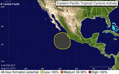
Forecast
Aug 20-25, 2011
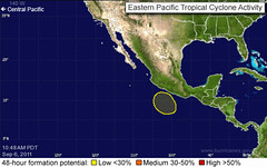
This forecast called for an area of disturbed weather to form off of the Mexican state of Jalisco and to approach the Baja Peninsula. The National Weather Service map below is from the 23rd and shows the fulfillment of the forecast affecting both the areas mentioned.
They reported the following:
A LARGE AREA OF DISTURBED WEATHER EXTENDS FROM JUST WEST OF PUERTO
VALLARTA MEXICO SOUTHWARD FOR SEVERAL HUNDRED MILES. SOME
DEVELOPMENT OF THIS SYSTEM IS POSSIBLE BEFORE IT MOVES WESTWARD
OVER COOL WATERS IN A DAY OR SO.
A LARGE AREA OF DISTURBED WEATHER EXTENDS FROM JUST WEST OF PUERTO
VALLARTA MEXICO SOUTHWARD FOR SEVERAL HUNDRED MILES. SOME
DEVELOPMENT OF THIS SYSTEM IS POSSIBLE BEFORE IT MOVES WESTWARD
OVER COOL WATERS IN A DAY OR SO.
Another forecast for this same period was for the central Caribbean where tropical storm formation was forecast between 75-77 west longitude around 12 north latitude. Although no independent system developed, it's interesting to see that Hurricane Irene, which was affecting the Bahamas at the time, was having an effect on the central Caribbean.
Here are the NWS comments from the 25th.
BROAD OUTFLOW FROM HURRICANE IRENE REMAINS OVER THE E AND CENTRAL CARIBBEAN DRAWING TROPICAL MOISTURE N ACROSS THE S CARIBBEAN AND GENERATING SCATTERED SHOWERS/ISOLATED THUNDERSTORMS S OF 15N TO INLAND OVER COLOMBIA BETWEEN 71W-76W AND S OF 13N TO OVER VENEZUELA BETWEEN
62W-66W.
Forecast
BROAD OUTFLOW FROM HURRICANE IRENE REMAINS OVER THE E AND CENTRAL CARIBBEAN DRAWING TROPICAL MOISTURE N ACROSS THE S CARIBBEAN AND GENERATING SCATTERED SHOWERS/ISOLATED THUNDERSTORMS S OF 15N TO INLAND OVER COLOMBIA BETWEEN 71W-76W AND S OF 13N TO OVER VENEZUELA BETWEEN
62W-66W.
Forecast
Aug 27-28, 2011
This last forecast mentioned a possible tropical system in the making just west of the Lesser Antilles that probably would not see conditions favorable for development.
This last forecast mentioned a possible tropical system in the making just west of the Lesser Antilles that probably would not see conditions favorable for development.
Results
On the 27th, the NWS reported:
A SURFACE TROUGH IS IN THE W TROPICAL ATLC ALONG 55W FROM 12N-16N MOVING
TOWARD THE LESSER ANTILLES WITH SCATTERED SHOWERS/THUNDERSTORMS
W OF THE TROUGH TO OVER THE LESSER ANTILLES.
A SURFACE TROUGH IS IN THE W TROPICAL ATLC ALONG 55W FROM 12N-16N MOVING
TOWARD THE LESSER ANTILLES WITH SCATTERED SHOWERS/THUNDERSTORMS
W OF THE TROUGH TO OVER THE LESSER ANTILLES.
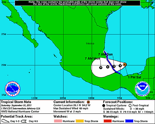
Tropical Storm Nate Fulfills Long-range Weather Forecast!
Tropical Storm Lee Fulfills Long-range Weather Forecast
Hurricane Irene Closely Fulfills Long-range Forecast
New Weather Alternative Website
Tropical Storm Harvey Fulfills Long-range Weather Prediction!
Hurricane Beatriz Fulfills Long-range Weather Prediction!
Hurricane Risk-Management
Hurricane Season 2011 Predictions
Overview of UK Winter 2012-13
The Winters of 2011-14
Fulfilled Long-range Forecasts for Hurricane Season 2010
Introduction to the Weather Alternative
How Long-Range Forecasts Are Made
Excerpts from Tidal Dynamics by Fergus J. Wood
An important fulfillment of Endtime Bible prophecy is the rebuilding of the Jewish temple in Jerusalem, which is to precede the return of Christ. Read more about it here.