Click here for November 2005 long-range weather forecasts.
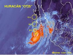
Hurricane Otis
Following is a forecast published in the September 2005 issue of El Quinto Sol, a Mexican magazine.
October 1-3, 2005:
Increasing temperatures disrupt atmospheric conditions. The target area is Northwest Mexico and the Gulf of California where there may even be some tropical activity or at least noticeable storms.
This is now being fulfilled in Hurricane Otis, which, according to the National Weather Service "is expected to steer WNW around a deep layered ridge eventually turning north and crossing the Central Baja Peninsula."
Friday, September 30, 2005
Monday, September 26, 2005
The Weather Alternative
From alternative music and media to alternative medicine, we're increasingly offered nontraditional replacements to mainstream methods, institutions and practices. Although conventional approaches serve a purpose, growing awareness of their limitations and flaws impel men to explore along the fringe for new, and in some cases, ancient solutions.
So why not alternative weather forecasts? Present day orthodox forecast techniques lack the ability to accurately predict the weather beyond three or four days. Even with the assistance of the largest weather computer in the world, whose lightning-fast calculations approach about 400 million per second, the results of its three-day forecasts are speculative; its six to seven day forecasts are worthless. According to conventional weather forecasters, this is due to the complexity of atmospheric forces and processes.
For example, on September 19, 2002 Tropical Storm Isidore roamed off the southwestern coast of Cuba. Forecasters were pretty confident its trajectory would take it over the island and then out into the waters of the south-central Gulf of Mexico. After that, it was anybody’s guess. One forecaster commented after noticing that computer models showed so much disagreement that it was time to dust off the chaos butterflies of MIT Professor Ed Lorenz. He was referring to the discovery Lorenz made while working with computer-simulated weather. Lorenz found that even a very slight alteration of the original variables used in his computations produced drastically different “weather” results. This small change in input resulting in a huge change in output was termed the “butterfly effect” since something as small as the wind produced by a butterfly’s flapping wings could theoretically contribute to the production of a hurricane somewhere in the world.
What some scientists see as complexity, however, might actually be viewed as simplicity when the frame of reference is changed. Johannes Kepler, the 17th century astronomer and discoverer of the planetary laws of motion, experimented with what today would be considered an alternative forecast method that made long-range weather forecasts possible. Kepler observed that the angular relationships among the planets coincided with the formation of weather systems here on Earth that, in turn, produced storms, droughts, floods, etc. His first brush with fame came not because of his breakthrough regarding the planetary laws of motion but because of his accurate long-range weather forecast of the severe winter that put Styermark, Germany on ice in 1593. Since the planets move in repetitive cycles that can be known beforehand, he reasoned, the weather induced by them can also be known beforehand.
We can all see the advantages that such predictions could have. Accurate long-range weather forecasts would bring enormous benefits to the weather derivatives market, agriculture, transportation, construction, and other industries, not to mention the lives that could be saved through advance knowledge of severe weather conditions.
The Weather Alternative's forecast system is based on Kepler's work. Although no forecast method, be it conventional or alternative, can claim 100 percent accuracy, it is interesting to note the dependability this method offers.
Saturday, September 24, 2005
More on Rita's Path
Hurricane Rita
On September 21st, I posted the following:
The Weather Alternative's forecasts are based on planetary cycles. One forecast model shows the potential for increased wind velocities and storm conditions around September 24, 2005 at 88 West Longitude and 30 North Latitude. This is roughly the area around Mobile, Alabama. With Rita now churning in the Gulf of Mexico, this may be an indication of where she makes landfall. Orthodox forecasters, at present, are showing possible landfall further west along the Texas Gulf Coast.
The aforementioned forecast model did not show Hurricane Rita's point of landfall, but it certainly did bring increased wind velocities and storm conditions around the Moblie, Alabama area on the 24th. Here's what the National Weather Service had to say:
URGENT - WEATHER MESSAGE
NATIONAL WEATHER SERVICE
MOBILE AL
1110 AM CDT SAT SEP 24 2005
...WIND ADVISORY REMAINS IN EFFECT THROUGH 400 PM TODAY...
...THE NATIONAL WEATHER SERVICE IN MOBILE HAS ISSUED A FLASH FLOODWATCH THROUGH SUNDAY...
SPIRAL BANDS OF HEAVY RAIN WILL PERIODICALLY MOVE ACROSS THE AREA TODAY...AND...TONIGHT AND SUNDAY AS RITA SLOWS AND BEGINS TO MOVE A LITTLE MORE TOWARD THE EAST OVER INTERIOR PORTIONS OF LOUISIANA AND SOUTHERN ARKANSAS...
RAIN ACCUMULATIONS WILL GENERALLY BE 1 TO 2 INCHES...WITH ACCUMULATIONS OF 2 TO 4 INCHES POSSIBLE TONIGHT THROUGH SUNDAY.
Wednesday, September 21, 2005
Rita's Path?
The Weather Alternative's forecasts are based on planetary cycles. One forecast model shows the potential for increased wind velocities and storm conditions around September 24, 2005 at 88 West Longitude and 30 North Latitude. This is roughly the area around Mobile, Alabama. With Rita now churning in the Gulf of Mexico, this may be an indication of where she makes landfall. Orthodox forecasters, at present, are showing possible landfall further west along the Texas Gulf Coast.
Friday, September 09, 2005
Long-Range Weather Forecasts November 2005
These forecasts were compiled between August 21, 2005 and September 6, 2005.
Atlantic
November 5-7, 2005:
Forecast: Tropical storm and/or hurricane development or passage is imminent around 72 West Longitude and 22 North Latitude. This is roughly 160 miles north of Haiti and somewhat southwest of the Bahamas. It may be a broad weather pattern that affects Hispanola and/or south of it.
November 5-6, 2005:
Forecast: The potential for tropical storm formation is indicated around 50 West Longitude and 8 North Latitude.
November 20-21, 2005:
Forecast: Tropical activity possible in and around 50 West Longitude and 8 North Latitude.
November 22-24, 2005:
Forecast: Tropical storm or hurricane formation is likely along 63 West Longitude and 20 North Latitude. This lies about 265 miles northeast of Puerto Rico.
Caribbean
November 1-2, 2005:
Forecast: Watch for heavy rains or a tropical system over area comprising Jamaica and eastern Cuba.
November 12-15, 2005:
Forecast: It seems that a tropical weather system, be it a tropical wave, storm etc., or other severe weather pattern will affect HispaƱola.
November 23-24, 2005:
Forecast: Tropical storm or heavy rains for the area around Jamaica and eastern Cuba.
U.S. Mainland
November 2-4, 2005:
Forecast: A cold Canadian air mass will sink southward over the northern Plains States with the potenial for triggering storms over the Dakotas, Minnesota, Nebraska, and Iowa.
November 2-4, 2005:
Forecast: A chilly air mass from northern regions will descend over the Northeast U.S. and generate wet and soggy conditions as it interacts with a moisture already in place.
November 3-5, 2005:
Forecast: A strong cold front will push into the West Coast area bringing rain and colder temperatures as it progresses through the Intermountain West.
The Rockies will eventually feel the brunt of this system especially over Utah and Colorado.
November 5-7, 2005:
Forecast: Another round of storms batters the West Coast States. Moist, warm air finds its way over the region producing "caffeinated" storms over the Intermountain West.
Forecast: As warm, moist air is funneled northward over the Plains, colder, drier air rushes southward over the Mississippi Valley. The inevitable result is that storms will erupt over both these areas as the colder air collides with this southerly invasion. Watch, in particular, for strong storms over the Arrowhead of Minnesota. Gusty winds usually accompany this pattern.
Forecast: Cold and windy conditions, originating in the central U.S., rush eastward toward the eastern Great Lakes, Mid-Atlantic, and Southeast.
Forecast: New England may be dealing with a weather phenomenon all its own. One forecast model indicates a storm system south of Maine, roughly at the latitude of Washington DC, that heads northward toward New England. This may represent a Nor’easter or a tropical system.
November 11-13, 2005:
Forecast: Cool and fair conditions are shown for the eastern portion of the country most likely courtesy of a high pressure system over Canada or the Great Lakes area.
November 13-15, 2005:
Forecast: Rising temperatures over the Intermountain West may erupt in thunderstorms.
November 14-17, 2005:
Forecast: The incursion of colder air over the eastern half of the country and consequent tumbling temperatures will necessitate frost and feeze advisories over the region. The 16th and 17th appear to be high points when cold air and windy conditions will manifest over the Mississippi Valley area.
November 15-17, 2005:
Forecast: An active weather pattern is promised for the Rockies as moisture is drawn up from the Gulf of California sparking severe thunderstorms over Arizona, Utah, and surrounding areas.
November 17-18, 2005:
Forecast: A robust weather system hits the West Coast as atmospheric conditions deteriorate resulting in a round of severe weather.
Forecast: Strong storms will bully the Plains States as conflicting atmospheric currents lay into each other.
November 19-20, 2005:
Forecast: Another bout of blustery weather and lower temperatures is shown for the Mississippi Valley and eastern U.S.
November 20-22, 2005:
Forecast: Another vigorous storm system will intensify over the West Coast States resulting in cold and wet conditions.
November 21-24, 2005:
Forecast: This promises to be a very active period for the Plains. The necessary ingredients to produce blizzard-like conditions seem to be present over the Northern Tier States.
November 23-25, 2005:
Forecast: Chilly air and blustery winds will whip the Rockies calling for high wind and winter storm warnings over the region.
November 23-24, 2005:
Forecast: The clash between high and low pressure systems will focus on the coastal areas of Virginia and North Carolina. High winds or severe storms are likely to hit this area. This may be part of a larger weather pattern that affects the Mid-Atlantic area.
November 27-29, 2005:
Forecast: A cool high pressure area will enter the West Coast. This drier air mass may ignite some storms and windy conditions in its attempt to establish itself over the region.
Forecast: Increasing wind speeds and falling temperatures will be the story from the western Great Lakes, across the Mississippi Valley, and eastward as cold Canadian air pushes southward. This weather pattern will extend across the eastern Great Lakes and into the Mid-Atlantic area etc. Inclement weather is also shown over northwest Texas.
Sunday, September 04, 2005
Long-Range Weather Forecasts
Coming Soon! Long-range weather forecasts for November 2005 will soon be posted on The Weather Alternative.
Subscribe to:
Posts (Atom)