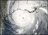
Hurricane Rita
On September 21st, I posted the following:
The Weather Alternative's forecasts are based on planetary cycles. One forecast model shows the potential for increased wind velocities and storm conditions around September 24, 2005 at 88 West Longitude and 30 North Latitude. This is roughly the area around Mobile, Alabama. With Rita now churning in the Gulf of Mexico, this may be an indication of where she makes landfall. Orthodox forecasters, at present, are showing possible landfall further west along the Texas Gulf Coast.
The aforementioned forecast model did not show Hurricane Rita's point of landfall, but it certainly did bring increased wind velocities and storm conditions around the Moblie, Alabama area on the 24th. Here's what the National Weather Service had to say:
URGENT - WEATHER MESSAGE
NATIONAL WEATHER SERVICE
MOBILE AL
1110 AM CDT SAT SEP 24 2005
...WIND ADVISORY REMAINS IN EFFECT THROUGH 400 PM TODAY...
...THE NATIONAL WEATHER SERVICE IN MOBILE HAS ISSUED A FLASH FLOODWATCH THROUGH SUNDAY...
SPIRAL BANDS OF HEAVY RAIN WILL PERIODICALLY MOVE ACROSS THE AREA TODAY...AND...TONIGHT AND SUNDAY AS RITA SLOWS AND BEGINS TO MOVE A LITTLE MORE TOWARD THE EAST OVER INTERIOR PORTIONS OF LOUISIANA AND SOUTHERN ARKANSAS...
RAIN ACCUMULATIONS WILL GENERALLY BE 1 TO 2 INCHES...WITH ACCUMULATIONS OF 2 TO 4 INCHES POSSIBLE TONIGHT THROUGH SUNDAY.
No comments:
Post a Comment