Click here for the Introduction to The Weather Alternative
The strong storms affecting the US East Coast are a direct fulfillment of the following long-range weather forecast. This forecast was prepared in December 2005, published in the July 2006 edition of Dell Magazine and posted on this blog in August 2006.
Forecast
Sept. 24-26:
A blast of cold air will assault the Mid-Atlantic and Southeast generating gusty winds and slashing temperatures.
Today Accuweather published the following map and comment.

The storm system that has pounded the Midwest and Mississippi Valley with severe weather recently will sweep southward and eastward this afternoon, spreading the severe weather threat from Bangor, Maine, to Albany, Georgia, and into Brownsville, Texas. The AccuWeather.com Severe Weather Center is urging residents or visitors across these areas to keep an eye to the sky and check back to AccuWeather.com as any of these thunderstorms has the potential to produce damaging winds, heavy rain and hail. In addition, isolated tornadoes cannot be ruled out.
In addition to the above forecast, The Weather Alternative also forecast the following:
Sept. 23-25:
A tropical weather system may be brewing near the Dominican Republic and tropical moisture unloads over the Florida Panhandle.
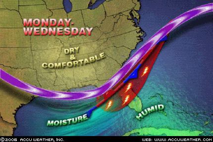 Accuweather reports: A frontal boundary will stall across northern and central Florida through the middle of the week. Moist air will continue to spread up along the front from Monday to Wednesday, leading to widespread showers and thunderstorms. The heaviest rainfall during the period will likely be from Gainesville to Orlando, Fla.
The National Weather Service published the following about the Dominican Republic:
TROPICAL WAVE IS OVER THE LESSER ANTILLES ALONG 62W S OF 20N MOVING SLOWLY WESTWARD AT AROUND 10KT. BROADENING INVERTED-V SIGNATURE CURVATURE WITH SCATTERED SHOWERS/ISOLATED THUNDERSTORMS FROM 13N-18N BETWEEN 58W-64W. THIS WAVE WILL MOVE ACROSS THE VIRGIN ISLANDS AND PUERTO RICO LATE TODAY TROUGH MONDAY AND IS EXPECTED TO REACH DOMINICAN REPUBLIC MONDAY AFTERNOON OR EVENING...INCREASING THE CHANCE OF RAIN OVER THOSE ISLANDS.
No comments:
Post a Comment