 According to the long-range weather forecast posted on June 8, 2009, the Mercury-Uranus opposition of Sept 23rd, along with Jupiter's activation of the Feb 6, 2008 solar eclipse, was to trigger possible tropical storm development about 450 miles east of the Windward Islands between Sept 23rd and 26th. This area lies roughly between 52 and 60 west longitude around 17 north latitude.
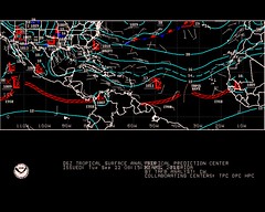
The National Weather Service map at left for Sept 22nd shows a low pressure system over the forecast area.
On September 24th, the NWS reported:
AN ATLANTIC OCEAN TROPICAL WAVE HAS BEEN MOVED TO 54W/55W TO THE SOUTH OF 19N...MOVING WEST 15 KT... IT IS POSSIBLE THAT STRONG ITCZ PRECIPITATION FROM9N TO 12N BETWEEN 52W AND 55W IS BEING ENHANCED BY THE WAVE.
Accuweather reported on Sept 25th:
Another tropical wave is along 58 west and south of 19 north and is moving west at 10-15 mph. Satellite shows most of the convection with this tropical wave south of 14 north. As it progresses westward, there will be an increase in showers and thunderstorms across the southern Windward Islands, but further development, if any, will be slow to occur.
Introduction to the Weather Alternative
How Long-Range Forecasts Are Made
Solar Eclipse Action October and November 2009
A Few More Forecasts for October 2009
Education
An American woman living in India was having a simple electrical installation done by a native electrician. He troubled her so much for instructions that she at last said irritably, "You know what I want; just use your common sense & do it." The electrician salaamed politely & said, "Madam, common sense is a rare gift of God. I have only a technical education."
No comments:
Post a Comment