West
Most charts coincide with a storm system moving through the Pacific Northwest into the Intermountain West on the 23rd and 24th. The coastal Pacific Northwest might get some pleasant weather on the 25th, but further inland over the Intermountain West the 26th and 27th looks stormy.
Results
A major storm entered the Pacific Northwest on the 22nd--a day before my forecast. Another weaker system moved in on the 24th bringing rain and some higher-elevation snow to the Pacific Northwest.
I foresaw pleasant weather on the 25th for the coastal Pacific NW. There was a break from the powerhouse storms on the 25h and high pressure over the Great Basin area but some rain and mountain snow still affected the coastal areas. A new front entered the Pacific Northwest on the 26th and moved inland to the Intermountain West on the 26th and 27th.
Plains
The 23rd starts with moist air being drawn up over Texas and the southern and eastern Plains initiating storms. Cooler air is drawn southward at this time over the Rockies triggering storms along the Front Range area. Around the 24th, the southern Rockies area centering around New Mexico will have unsettled weather. More cooler Canadian air makes it way southward on the 25th and 26th over the Northern Plains and then meets with moist air creating storms over the Plains.
Results
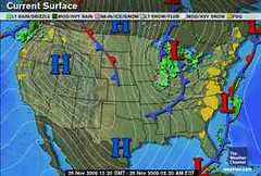
On the 23rd, Accuweathr reported Farther west in the Southern Plains, a developing system will bring showers and thunderstorms to the Plains and Lower Mississippi Valley tonight and tomorrow. The above Weather Channel map for the 23rd also shows a low pressure system over the Front Range area with a cold front headed into New Mexico.
On the 25th, Accuweather reported that cold winds blasted the northern Plains.
Mississippi Valley
The mid-Mississippi Valley area in and around Missouri shows a low pressure area or front bringing rain around the 24th. By the 25th and 26th this develops into more rainy weather for the Mississippi Valley.
Results
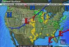
The above Weather Channel map for the 24th shows the predicted low pressure system over Missouri. This low continued to pester the northern Mississippi Valley area on the 25th and brought blustery conditions to the Mississippi Valley and western Great Lakes on the 26th.
 Forecast
East
On the 23rd, a front is indicated running the length of the East Coast from Florida through New York generating showers. On the 24th, with more moisture being funneled up over Florida and the Southeast, storms are indicated over the area in and around North Carolina and Virginia. Fair conditions seem to make it into the Southeast, Mid-Atlantic, and Northeast by the 25th and 26th.
Results
Although there was no front running hte length of the East Coast from Florida to New York on the 23rd, the whole forecast area did experience showers on that day. An area of low pressure brought rain as it traveled from the Carolinas to New England. The tail end of a front also brought showers to the Florida Peninsula.
I predicted more rain for Florida and the area in and around North Carolina and Virginia on the 24th. The main rain event over the forecast area didn't happen until the 25th.
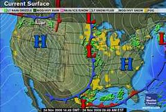
The Weather Channel map above for the 26th, shows the fair conditions making it into the Southeast, Mid-Atlantic, and Northeast. Notice the area is between two fronts.
 Forecast
New England
The 26th and 27th are very stormy over the New England area. Indications of severe weather in the lunar eclipse chart of August 5, 2009 will be activated now. The last time these were triggered tropical rainstorm Danny gave a glancing blow to the New England area bringing winds gusting between 40-60 mph and flash flooding due to torrential rainfall that dropped between 2-5 inches of rain. Yikes!
Results
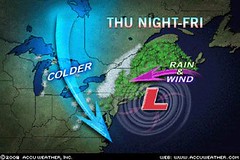
On the 26th a coastal storm over the Carolinas built up and hit New England on the 27th as predicted. I equated this storm to tropical rainstorm Danny since both storms had the same astro-meteorological cause based on the lunar eclipse of Aug 2009. The results were similar. On the 27th, New England had heavy rain and wind gusts of 40 to 50 mph. The storm ushered in cold and the windy conditions created power outages and downed trees.
Introduction to the Weather Alternative
How Long-Range Forecasts Are Made
Christmas and New Year's Weather Forecast United States and Europe
Super Bowl Sunday 2010 Weather Forecast
Saint Patrick's Day 2010 Weather Forecast
Twinkles?
By Gina Bridgeman, Guideposts
One day when my daughter Maria and I were playing on the bed, she suddenly pointed to the fine lines beside my eyes.
"What are these?" she asked.
"Wrinkles," I said. I thought, Oh, great-now my two-year-old has to remind me I'm not getting any younger.
"Twinkles," she said, pleased with herself.
"No, wrin-" I stopped in mid-correction. "You know, that makes them sound like something good, Maria. Twinkles they are."
That night as I looked in the mirror, I realized that my twinkles do come from smiling and laughing, forming a kind of road map of the great joy with which God has blessed my life. From parents who filled our house with laughter and taught us not to take ourselves too seriously, and brothers who are still two of the funniest people I know, I learned the value of a laugh a day. If there's one gift God has given me in abundance, it's joy, and I have the twinkles to prove it.
I'm turning forty, and while I haven't been particularly excited about it, or about those subtle lines or my one pesky gray hair that returns each time I snip it off, I'm ready to look at it all in a new way. Mark Twain wrote, "Wrinkles should merely indicate where smiles have been." So rejoice in the twinkles! They're a sign to the world that God has given me a lot to smile and laugh about.
Joyful Creator, in Your grace continue to fill my life with laughter, joy and an abundance of twinkles.


2 comments:
A high pressure is building in the gulf of alaska and sometimes when this happens, it forces the jet stream south over calif. Does your harmonic work confirm the change in weather pattern and the start of our wet season?
Hey, Bob!
I haven't gotten to look at the complete picture yet but here are some dates of what at first glance appears to be lining up.
It appears to be stormy over California around Dec 7th.
The 9th and the 10th indicate a warm and apparently dry influence.
The 13th through the 16th looks very interesting. I'm thinking it starts off with a rain event around Nevada and southern Cal.
As we get into the 15th and 16th, it looks like more of the same for Nevada and southern Cal., but with a stronger storm off the West Coast maybe in the Gulf of Alaska pushing its way into the Pacific NW.
My Christmas forecast already deals with the West Coast for Dec 20-22.
Post a Comment