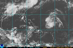
On August 2nd, the Weather Channel reported a tropical wave moving ashore in Central America near Nicaragua that produced some locally heavy rainfall over Central America for the next day or two.
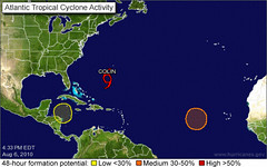
The National Weather Service map below is for today, August 6th. The yellow circle to the left is over Nicaragua and Honduras. This is represents a tropical wave that is bringing increased showers and thunderstorms over the region for the next couple of days but will most likely not develop into a tropical cyclone.

Experimental Forecasts Part 2- July-Sept 2010
Tropical Storm Alex Fulfills Long-range Prediction!
Bonnie Fulfills Long-range Forecast!
Experimental Forecasts July & August 2010
Hurricane Season 2010--Caribbean, Mexico, Central America
Hurricane Season 2010--Forecasts for August
Hurricane Season 2010--Forecast for September
Hurricane Season 2010--Central America Part 2
Introduction to the Weather Alternative
How Long-Range Forecasts Are Made
Thought of the Day
“In the end, it’s not the years in your life that count. It’s the life in your years.”—Abraham Lincoln
He who every morning plans the transactions of the day and follows out that plan, carries a thread that will guide him through the labyrinth of the most busy life.—Victor Hugo
No comments:
Post a Comment