The forecast was for March 18-20 and called for cold air to enter over the Mississippi Valley and
Great Lakes area. I foresaw a storm system developing over the Kentucky/Tennessee area down through the Florida Panhandle. I also forecast a storm system to hit the New England area. The idea was that these storm systems would be intensified due to the influence of the SuperMoon.
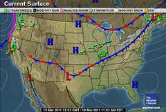
The above weather map is from the Weather Channel for March 18th and shows cold air entering the Great Lakes and Mississippi Valley area and a storm system affecting New England. Accuweather reported that this storm system buffeted upstate New York and New England with strong, gusty winds of 30 to 40 mph with gusts up to 50 mph.
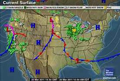
By the 20th a storm system moved in over the Great Lakes area threatening Iowa, Wisconsin, and Illinois with rain and a few thunderstorms capable of torrential downpours, gusty winds, and hail. Nothing really formed over the Kentucky/Tennessee area or down to the Florida Panhandle execpt for that little low pressure area and cold front along the Gulf Coast.
The real action was out in California at this time, as can be seen on the above map. Storms were slamming the state with drenching rain and snow.
Some astro-meteorologists think you should give a larger window for your forecast during a SuperMoon and allow 2 or 3 days on either side.
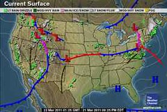
This next map is for today, one day passed my forecast, and shows a stronger storm heading for New England. So within the forecast dates we did have a cold front affecting the forecast area and a storm system hitting New England. The intensity was less than I expected and also nothing really developed from Kentucky-Tennessee down to Florida.
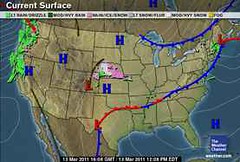
In another forecast posted back in November of 2010, I called for a cold front over the Midwest on March 13th and 14th. This next Weather Channel map shows the cold front entering the Midwest on the 13th.
Cyclone Yasi fulfills long-range prediction!
Overview of UK Winter 2012-13
The Winters of 2011-14
Tropical Storm Matthew Fulfills Long-range Forecast!
Hurricane Earl and T.D. 10E Fulfill Long-range Forecasts!
Tropical Storm Alex Fulfills Long-range Prediction!
Bonnie Fulfills Long-range Forecast!
Introduction to the Weather Alternative
How Long-Range Forecasts Are Made
Excerpts from Tidal Dynamics by Fergus J. Wood
No Fly Zone
No comments:
Post a Comment