The close conjunction of Mercury and Venus throughout the May 8-17 period was the basis of the long-range forecast posted on April 29th. There were basically three areas that were emphasized: the Plains, the western Atlantic, and the West Coast.
The Plains
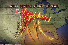
The first portion of the forecast for the Plains spoke of increasing temperatures due to a moist, southerly airflow and the possibility of damaging thunderstorms, hail, and tornadoes. The areas to be affected were the Texas and Oklahoma panhandles and eastward toward the Mississippi Valley.
The first Accuweather map shows the severe thunderstorm threat for the 8th through the 10th over Texas and Oklahoma and continuing toward the Mississippi River Valley.
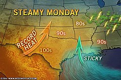
The next Accuweather map for the 9th confirms the increasing temperatures and moisture talked about in the forecast.
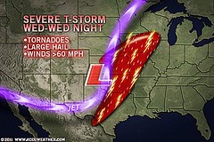
Greatly enhanced storm potential was the forecast for the Plains during the May 10-12 period.
This next map for the 11th shows the area slated for tornadoes, large hail, and severe thunderstorms.
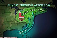
The forecast for the final period, May 14-17, specified through the Plains, Deep South, and East Central States. This next map shows the lingering low pressure area affecting the East Central and Northeast States from the 15th through the 18th.
The Western Atlantic
The forecast for the whole period mostly concentrated on an area roughly 420 to 475 miles northeast of the Lesser Antilles centering around 54 west longitude and 19 north latitude, and looked for a low pressure system (not necessarily tropical) that would affect the area. A strong low was forecast to develop between the 14th through the 17th.
The National Weather Service made the following comments throughout the period:
May 9: Low-level moisture continues to pool along a surface trough from 18N55W into the NE Caribbean...
May 11: A SURFACE TROUGH IS OVER THE W TROPICAL ATLC INTO THE NE CARIBBEAN EXTENDING FROM 21N55W ACROSS THE VIRGIN ISLANDS NEAR 18N63W.
May 15: ANOTHER LOW PRESSURE SYSTEM IS IMPACTING THE CENTRAL ATLC. AN UPPER LEVEL TROUGH IS ALONG 53W...
The following weather map is for May 15 and shows the area mentioned.
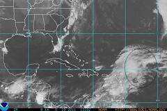
This low pressure area around May 15th was broad enough that it affected Puerto Rico and the Virgin Islands with strong storms. Accuweather reported "More Drenching Storms for Puerto Rico, Virgin Islands. Drenching showers and thunderstorms will continue to soak the northeastern Caribbean Islands through at least early next week..."
West Coast
Between the 10th and the 17th, the West Coast was forecast to experience an increase in heat and moisture leading to storms over California, Washington, Oregon, and Idaho.
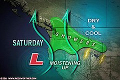
On the 14th, a low pressure area hit the West Coast States of Washington, Oregon, and Idaho as shown in the following Accuweather map. Their title was "Storm to Slam West Coast this Weekend."
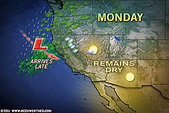
On the 16th, Accuweather reported "The next shot of rain will advance onshore over northern California later today. " Here's their weather graphic.
The Plains
The first portion of the forecast for the Plains spoke of increasing temperatures due to a moist, southerly airflow and the possibility of damaging thunderstorms, hail, and tornadoes. The areas to be affected were the Texas and Oklahoma panhandles and eastward toward the Mississippi Valley.
The first Accuweather map shows the severe thunderstorm threat for the 8th through the 10th over Texas and Oklahoma and continuing toward the Mississippi River Valley.
The next Accuweather map for the 9th confirms the increasing temperatures and moisture talked about in the forecast.
Greatly enhanced storm potential was the forecast for the Plains during the May 10-12 period.
This next map for the 11th shows the area slated for tornadoes, large hail, and severe thunderstorms.
The forecast for the final period, May 14-17, specified through the Plains, Deep South, and East Central States. This next map shows the lingering low pressure area affecting the East Central and Northeast States from the 15th through the 18th.
The Western Atlantic
The forecast for the whole period mostly concentrated on an area roughly 420 to 475 miles northeast of the Lesser Antilles centering around 54 west longitude and 19 north latitude, and looked for a low pressure system (not necessarily tropical) that would affect the area. A strong low was forecast to develop between the 14th through the 17th.
The National Weather Service made the following comments throughout the period:
May 9: Low-level moisture continues to pool along a surface trough from 18N55W into the NE Caribbean...
May 11: A SURFACE TROUGH IS OVER THE W TROPICAL ATLC INTO THE NE CARIBBEAN EXTENDING FROM 21N55W ACROSS THE VIRGIN ISLANDS NEAR 18N63W.
May 15: ANOTHER LOW PRESSURE SYSTEM IS IMPACTING THE CENTRAL ATLC. AN UPPER LEVEL TROUGH IS ALONG 53W...
The following weather map is for May 15 and shows the area mentioned.
This low pressure area around May 15th was broad enough that it affected Puerto Rico and the Virgin Islands with strong storms. Accuweather reported "More Drenching Storms for Puerto Rico, Virgin Islands. Drenching showers and thunderstorms will continue to soak the northeastern Caribbean Islands through at least early next week..."
West Coast
Between the 10th and the 17th, the West Coast was forecast to experience an increase in heat and moisture leading to storms over California, Washington, Oregon, and Idaho.
On the 14th, a low pressure area hit the West Coast States of Washington, Oregon, and Idaho as shown in the following Accuweather map. Their title was "Storm to Slam West Coast this Weekend."
On the 16th, Accuweather reported "The next shot of rain will advance onshore over northern California later today. " Here's their weather graphic.
Hurricane Season 2011 Baja, Mexico
Hurricane Risk-Management
Hurricane Season 2011 Predictions
Overview of UK Winter 2012-13
The Winters of 2011-14
Cyclone Yasi fulfills long-range prediction!
Tropical Storm Matthew Fulfills Long-range Forecast!
Hurricane Earl and T.D. 10E Fulfill Long-range Forecasts!
Tropical Storm Alex Fulfills Long-range Prediction!
Bonnie Fulfills Long-range Forecast!
Introduction to the Weather Alternative
How Long-Range Forecasts Are Made
If Evolution Were Really True, It Would Look Like This...

No comments:
Post a Comment