The next forecast that appeared in The Mountain Astrologer Feb/Mar 2012 issue covered January 7th and 8th.
Forecast
January 7-8, 2012
Mercury and Venus activate Uranus and Pluto now by square and semi-square. Abruptly falling temperatures with northwest wind push down over the Great Lakes into eastern U.S. and bring the potential for wintry precipitation. Other key charts indicate that wintry weather will be felt over Nevada, Oklahoma, and Iowa.
This should be an active weather period for Europe. Blustery northwest wind should push eastward over Ireland through the UK, Portugal, and Spain towards Germany. Similarly, Uranus-Pluto over China indicates sudden temperatures drops and northwest winds pushing into the country's center.
Results
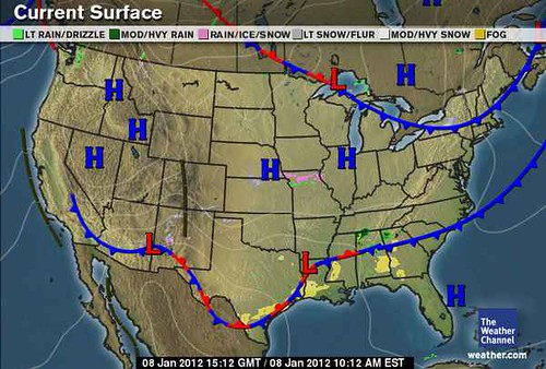
The falling temperatures mentioned for the Great Lakes and eastern U.S. are shown in the following Weather Channel map for January 8th. Notice the cold front pushing over the whole area.

Winds were also experienced over the Great Lakes as shown by the NWS gale warning on the 7th for Marquette, MI.
... GALE WATCH REMAINS IN EFFECT FROM LATE SUNDAY NIGHT THROUGH MONDAY AFTERNOON...
Wintry weather was forecast for Nevada, Oklahoma, and Iowa.
Nevada
The National Weather Service warned that on the 7th and 8th
A TROUGH OF LOW PRESSURE WILL MOVE THROUGH NORTHERN AND EASTERN NEVADA BRINGING SNOW SHOWERS AND A LOT OF COLD AIR...SOME GUSTY WINDS COULD DEVELOP OVER NORTHEAST NEVADA WHICH MAY BRIEFLY IMPACT TRAVEL ALONG HIGHWAY 93 FROM WELLS TO JACKPOT...TEMPERATURES WILL DROP RAPIDLY AND SINGLE DIGITS ARE EXPECTED BY DAYBREAK SUNDAY.
Oklahoma
A COLD FRONT IS FORECAST TO PUSH SOUTH OF THE PANHANDLES BY SUNDAY MORNING WITH MUCH COLDER AIR RETURNING TO THE AREA. SNOW IS EXPECTED TO MOVE INTO THE NORTHWEST PANHANDLES SUNDAY MORNING AND IS EXPECTED TO SPREAD SOUTHWARD ACROSS MOST OF THE AREA BY SUNDAY NIGHT.
The Accuweather map below shows a bigger picture of the weather affecting that area.

Iowa
No wintry weather was reported for Iowa.
Europe
Wet and windy weather was reported for Europe starting on the 6th. Heavier showers and stronger winds blew into Germany and Poland on the 7th. On the 8th, a strong mistral affected southern France.
China
The Chinese Meteorological Administration reported the following on January 5th:
In the next 3 days, there will be last overcast, rain and snow in most of southern China. The last rain and snow will influence eastern Qinhai-Tibet Plateau and most southern parts of China. Central and northern Guizhou, northern South of the Yangtze River will get light to moderate or sleet. The freezing rain will hit central and western Guizhou while moderate to heavy snow affect southwestern Tibet.
Winter 2011-12 The Rockies
Winter 2011-12 West Coast
Hurricane Season 2011 Forecast Results
Hurricane Risk-Management
Update on Winter 2011-12
Texas Summer 2012
New Weather Alternative Website
Overview of UK Winter 2012-13
The Winters of 2011-14
Fulfilled Long-range Forecasts for Hurricane Season 2010
Introduction to the Weather Alternative
How Long-Range Forecasts Are Made
Twelve Triggers For World Government (read more)

No comments:
Post a Comment