In Testing Astrometeorology Part 1, I looked at the effect that Sun-Saturn
oppositions are reported to have on weather systems. In this test of
astrometeorology, I want to see if the system of long-range weather forecasting
based on planetary cycles that has been handed down to us over the centuries is
reliable. There are basically three components that make up the system. When
taken together, they should provide us with the following information: what
kind of weather we should expect, when we should expect it, and where we should
expect it.
The “what” is determined by the natures of the planets involved. In the
case of the Sun-Saturn opposition, tradition tells us cold, stormy periods
delivering rain, snow, hail, etc., depending on the season in question, are to
be expected. The “when” is shown by the dates on which the aspect takes place.
This can be found by consulting an ephemeris that lists the date and time of
planetary aspects. The “where” can be determined by erecting key astrological
charts that show where the planets in question fall across the earth’s surface.
In Part 1, I used the Cardinal Solar Ingress chart for this purpose since this
is the main chart for the season in question.
In this post, I’ll look at some Sun-Saturn conjunctions using the same
criteria. Let’s see if the what, when, and where can be reliably determined by
this method. If so, then astrometeorology should be a dependable tool for
making long-range weather forecasts since we can know when and where these
aspects will take place months and years before they do.
According to G. J. McCormack, the 20th Century’s most able
long-range weather forecaster, the Sun-Saturn conjunction is similar in effect
to the Sun-Saturn opposition. In all seasons, McCormack states that the
conjunction brings low pressure areas with heavy precipitation, cold, and
easterly winds. The one exception McCormack mentions is Saturn’s transit
through the zodiacal sign Leo, which brings hot weather since Saturn
“concentrates the influence of the sign in which it may be posited at any
time.” Since Leo is a hot, dry sign, Saturn here brings hot, dry weather. Then,
when the Sun conjoins Saturn in Leo, the heat wave is broken. Let’s look at
some recent Sun-Saturn conjunctions and see how they fair.
June 24, 2003
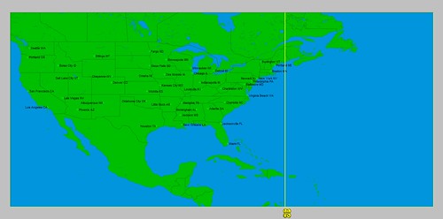
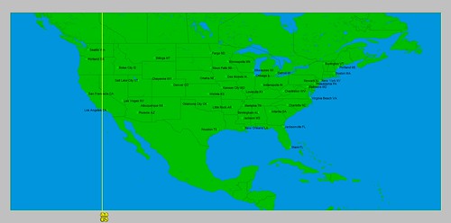
As seen below, the Solar Ingress map for the summer of 2003 placed the
Sun-Saturn conjunction over 104 west longitude. We should expect to see its
effects over the Rockies and Plains.

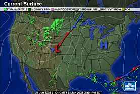
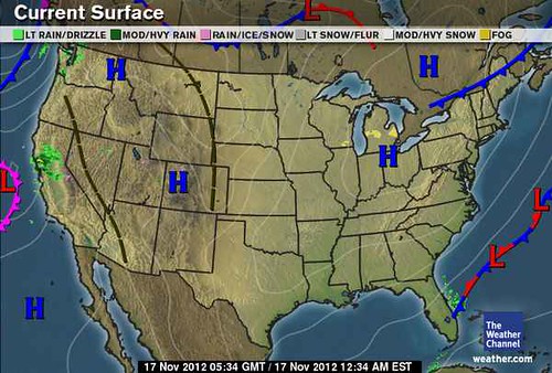
The Weather Channel map below is for June 24, 2003. We can see a low
pressure system over the exact area mentioned above with rain affecting the
Rockies and a stationary front across the Northern Plains.

On the 23rd, The Weather Channel reported “Scattered severe storms and isolated tornadoes will do a substantial
amount of saber rattling from southeastern Wyoming into the Upper Midwest,
especially across eastern South Dakota, much of Nebraska, southern Minnesota
and northern Iowa. Locally heavy downpours will deluge pretty much the same
areas, too, especially during the overnight hours both tonight and tomorrow as
scattered storms cluster into unruly gangs.”
The Weekly Weather and Crop Bulletin for
the week of June 22-28, 2003 reported that cool weather in Montana, the
Dakotas, and western Nebraska was a much as 10 degrees below normal. Widespread
beneficial precipitation accompanied the lower temperatures in Wyoming and
northern Utah. Between the 22nd and 25th, severe storms
and more than 75 tornadoes erupted across the Plains and upper Midwest.
July 23, 2005
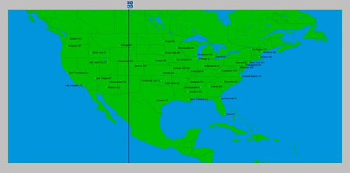
The Sun-Saturn conjunction took place over 68 west longitude which runs
through eastern Maine.

The conjunction took place in Leo. As mentioned above, Saturn in this sign can bring heat. Saturn entered Leo on the 16th of July and the National Weather Service began issuing excessive heat watches for Delaware and Washington D.C. on the 17th. Heat continued to plague the Northeast and New England. The Sun-Saturn conjunction took place on the 23rd. Shortly thereafter, on the 26th the heat wave was broken. The Weather Channel reported that “after an extended period of hot and humid conditions, residents of the Northeast will finally get a break as a significant cold front slides through the region.”
 August 7, 2006

Saturn was also in Leo during this period. The first week of August brought record heat to the Northeast. The Sun’s conjunction with Saturn on the 7th broke the heat wave. Accuweather headlines for the 7th read “Cold Front Takes Aim on the Northeast” The front brought locally strong to severe storms. The following Weather Channel map for the 8th shows the cold front.
 September 3, 2008
Here we find the Sun-Saturn conjunction over 106 west longitude.

Temperatures were 5 to 20 degrees below average in Montana, Wyoming, eastern Idaho, northern Utah, and Colorado according to the Weather Channel’s September 4th report.
September 17, 2009
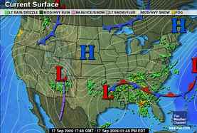
This next example is more than a Sun-Saturn conjunction and as such really does not fit in this series. At this time Saturn was in exact opposition to Uranus. So the Sun came along and conjoined Saturn as well as opposed Uranus. They were over the Mississippi Valley. This was a longer lasting influence due to the slower moving planets which lasted from the 17th through the 26th.

During this period a pesky, slow-moving low pressure area drenched the Southeast as can be seen in the Weather Channel map for the 17th. As much as 4 to 8 inches of rain fell from northeastern Texas to the central Appalachians. Between the 20th and 26th, severe flooding affected a broad area around northern Georgia. Four inches of rain fell for a second week from northern and central Mississippi eastward into the southern Appalachians.
 October 13, 2011
The Sun-Saturn conjunction appears over 119 west longitude.

Blazing heat baked the entire Southwest U.S. at this time. What stands out is Saturn’s association with an east wind. In this area of the country, an east wind does not import any moisture because it comes from the interior, dry desert areas of the Great Basin etc. At this time the normal onshore flow that keeps this area cool was replaced by an offshore flow or east wind bringing high heat.
Conclusion
By and large, the Sun-Saturn conjunction appears to live up to its reputation as a breeder of cold weather, low pressure areas, heavy precipitation, and east wind. Only in the last example was there no precipitation, but considering the time of year, and the geographical location, we can understand why. An east wind over New England blows off the sea and often brings a “backdoor cold front” with plenty of moisture. An east wind, however, over the desert Southwest has access to hot, dry air from desert regions.
Hurricane Sandy Fulfills Long-range Weather Prediction!
Testing Astrometeorology Part 1
Fall Weather 2012: Eastern U.S.
Fall Weather 2012: New England
Fall Weather 2012: Central U.S.
Fall Weather 2012: The U.S. West Coast
Mars Conjunct Saturn August 15, 2012
Jupiter-Neptune and Heavy Rain
The Solar Eclipse of November 13, 2012
Long-range effects of the May 20, 2012 Solar Eclipse
Long-range effects of the May 20, 2012 Solar Eclipse Part 2
Hurricane Season 2011 Forecast Results
Hurricane Risk-Management
New Weather Alternative Website
Overview of UK Winter 2012-13
The Winters of 2011-14
Fulfilled Long-range Forecasts for Hurricane Season 2010
Introduction to the Weather Alternative
Doublespeak Click to listen to the song

 Testing Astrometeorology Part 2