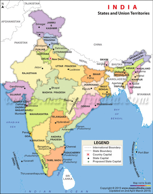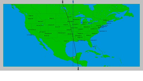
In my June 2015 article in Dell Horoscope, I mentioned that there was a chance that a low pressure system could manifest over the Louisiana area around June 21st due to the placements of Mercury and Neptune in the key summer season chart. Here's a visual representation of how those two planets affect the area.
This crossing that we see over Louisiana has the potential to be activated later on in the season, and different forecasts will come up over the next months that will focus on this. But in the article, I thought that around June 21st we might see some low pressure activity since Mercury would square Neptune on the 23rd. In astro-meteorology, squares are disruptive influences on weather patterns. In the next map below, we see their positions on the 23rd, when they perfect their square. The crossing moves southward into the Gulf of Mexico.
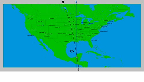
You'll notice I put a little circle to the left of the crossing. That's because on the 25th a tropical wave was moving through that corner of the Gulf and positioned at 94 west longitude and 24 north latitude where the circle is. Prior to this, the tropical wave was over the Yucatan on the 24th.
Links to Other Long-range Weather Forecasts and Forecast Results
Hurricane Season 2015 Long-range Weather Predictions
Tropical Cyclone Hadi
Hurricane Erick Fulfills Long-range Forecast
Tropical Storm Andrea Fulfills Long-range Forecast!
Timing the Relief for Drought-Stricken U.S. Plains
Testing Astrometeorology Part 2
Hurricane Sandy Fulfills Long-range Weather Prediction!
Testing Astrometeorology Part 1
Hurricane Season 2011 Forecast Results
Hurricane Risk-Management
New Weather Alternative Website
Fulfilled Long-range Forecasts for Hurricane Season 2010
Introduction to the Weather Alternative
When Reality Clashes with Your Worldview
Friday, June 26, 2015
Saturday, June 13, 2015
June 9-12, 2015 Forecast Results
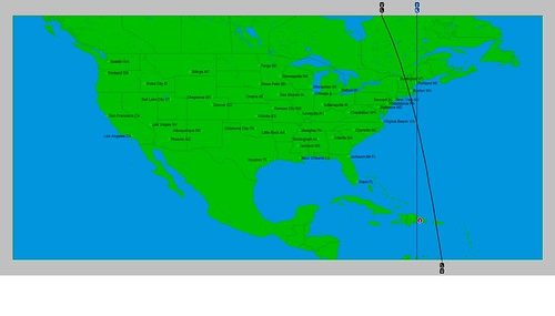
The first forecast of my article Celestial Storm Warnings that appears in the June 2015 edition of Dell Horoscope is for the period between June 9-12. The forecast was based on the astro-locality map below where we see two planetary lines (those of Mercury and Neptune) crossing south of New England and east of Virginia around 70 west longitude and 36 north latitude.
Although the article deals with hurricane forecasts, I mentioned it might be too early on in the season at this particular location for a tropical system to form. Therefore, I said there might be a non-tropical low pressure area that forms there or a front.
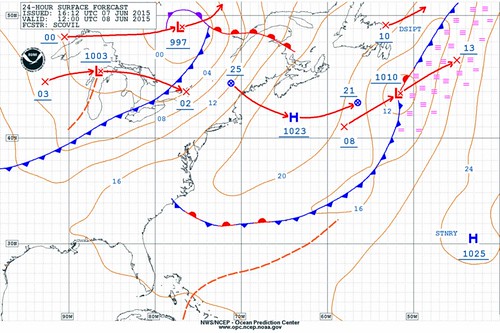
The National Weather Service forecast map for June 8th shows a stationary front forming over 70 west longitude and about 33 north latitude, as shown in the next map.
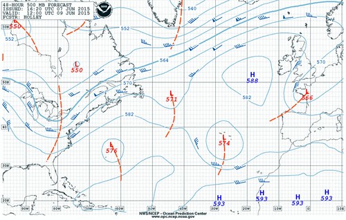
Then on the 9th, the NWS map shows a low pressure area forming around 35 north latitude but a bit farther east at around 64 west longitude. It's shown on the next map and labeled with an "L" and the number 576.
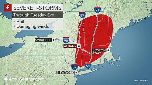
It's interesting to note that the planetary lines in the astro-locality map extend northward through New England. On the 9th, AccuWeather.com posted the following map showing severe thunderstorms with hail and damaging winds for the New England area.
Links to Other Long-range Weather Forecasts and Forecast Results
Hurricane Season 2015 Long-range Weather Predictions
Tropical Cyclone Hadi
Hurricane Erick Fulfills Long-range Forecast
Tropical Storm Andrea Fulfills Long-range Forecast!
Timing the Relief for Drought-Stricken U.S. Plains
Testing Astrometeorology Part 2
Hurricane Sandy Fulfills Long-range Weather Prediction!
Testing Astrometeorology Part 1
Hurricane Season 2011 Forecast Results
Hurricane Risk-Management
New Weather Alternative Website
Fulfilled Long-range Forecasts for Hurricane Season 2010
Introduction to the Weather Alternative
Monday, June 08, 2015
Update on India Heat Wave and Monsoon
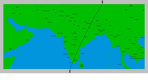
The May 30th post, India Heat Wave, discussed one of the planetary influences at work over the country that, from an astro-meteorological standpoint, indicated the heat wave. I also ventured to say that the Full Moon chart of June 2nd would set up a different planetary influence that would be an indication of a pattern change to wetter conditions. This was due to Venus occupying the eastern coast of India. In astro-meteorology, Venus in the sign Cancer, is indicative of increasing moisture and showers. The map below shows the position of Venus at the time of the Full Moon.
Following are a few news reports of monsoon activity over the Indian subcontinent in recent days confirming an influx of moisture over the regions that Venus occupied at the Full Moon. I've included a political map of India in order to recognize more easily the states affected by the monsoon rains.
On June 5th, the India Meteorological Department stated that "Monsoon Hits Kerala." From the political map, we see that Kerala is located on the southwestern tip of the subcontinent. The astro-locality map shows the Venus line passing over that area. In the same post, the IMD stated that parts of Tamil Nadu and Andhra Pradesh could expect the advance of the monsoon in the next 48 hours. These areas fall under the Venus line in the astro-locality map.
The news story on June 6th read "Rains lash Andhra, Telangana; conditions conducive for monsoon." We'll note that Telangana is also under the Venus line. The article declared that these pre-monsoon showers brought down temperatures to the delight of the inhabitants of these areas.
Today's news report for June 9th indicated that a cyclonic circulation is now present over the coastal areas of Andhra Pradesh bringing good rainfall to the area. The report also mentions that the monsoon will remain active over Northeast India, which we can see from the astro-locality map, is under the influence of the Venus line.
Links to Other Long-range Weather Forecasts and Forecast Results
Hurricane Season 2015 Long-range Weather Predictions
Tropical Cyclone Hadi
Hurricane Erick Fulfills Long-range Forecast
Tropical Storm Andrea Fulfills Long-range Forecast!
Timing the Relief for Drought-Stricken U.S. Plains
Testing Astrometeorology Part 2
Hurricane Sandy Fulfills Long-range Weather Prediction!
Testing Astrometeorology Part 1
Hurricane Season 2011 Forecast Results
Hurricane Risk-Management
New Weather Alternative Website
Fulfilled Long-range Forecasts for Hurricane Season 2010
Introduction to the Weather Alternative
Must Read! The Real Crash: America's Coming Bankruptcy
Subscribe to:
Posts (Atom)