Mainland Hurricane Outlook
July 2005
The weather patterns indicated in these forecasts may denote tropical storm or hurricane activity but not necessarily. The actual weather pattern experienced may be a severe weather pattern of a non-tropical or semi-tropical nature.
Forecast
July 9-11, 2005:
A storm system bringing whipping winds is shown for the Florida Peninsula. This may be due to a tropical system approaching from the south. Severe weather will also threaten the Mississippi Valley area and the Deep South around Mobile.
Results
July 10, 2005
Hurricane Dennis affects Florida
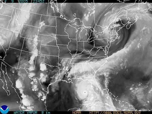
Photo courtesy of NOAA
Forecast
July 10-13, 2005:
The formation or passage of a tropical storm or hurricane may take place around 95 West Longitude and 28 North Latitude. This lies approximately 200 south of Galveston, Texas.
Results
July 10, 2005: (National Weather Service)
IN THE UPPERLEVELS...CYCLONIC CIRCULATION WITH STRONG SUBSIDENCE IS CENTEREDNEAR 27N94W. THE ATMOSPHERE IS TOO STABLE AND DRY TO SUPPORTANY SIGNIFICANT CONVECTION W OF 90W(In other words storm formation not likely)
July 11-13, 2005:
An influx of tropical moisture is indicated over the New England area. This usually results in warmer temperatures and substantial rains. Other models show the possibility of a storm system originating or passing over the Bahamas, hitting the Mid-Atlantic area, and continuing on through New England.
(No tropical moisture reported)
July 11, 2005: (The Weather Channel) NortheastA backdoor cold front will drop temperatures significantly on Tuesday across New England and to a lesser degree southward into New Jersey and Delaware. There may be a few scattered thundershowers with this front, as well.
Forecast
July 12-14, 2005:
Severe weather conditions will prevail over the Florida Panhandle—an all too familiar landing place for tropical storms and hurricanes. Stormy conditions, along with rising temperatures and humidity will also take aim on the East Coast States from the Carolinas northward through Pennsylvania.
Results
July 12, 2005: (The Weather Channel)South...locally heavy downpours possible in the Deep South.
July 13, 2005: (The Weather Channel)
South
Scattered showers and storms will roam the South once again tomorrow, especially during the afternoon and evening, as tropical moisture clings to the region.
July 14, 2005: (The Weather Channel)
South
...thunderstorms across the South right through the weekend. Locally heavy rainfall and flooding will occur where storms train (move over the same area). While no widespread severe threat exists, a few thunderstorms may be capable of producing damaging wind gusts.
July 15, 2005: (National Weather Service)...SLOW MOVING THUNDERSTORMS PRODUCING TORRENTIAL RAINFALL IN THE MOUNTAINS AND NORTHERN FOOTHILLS OF NORTH CAROLINA......SLOW MOVING SHOWERS AND THUNDERSTORMS TO OVERSPREAD NORTHEAST GEORGIA AND WESTERN AND CENTRAL UPSTATE SOUTH CAROLINA...
SPECIAL WEATHER STATEMENTNATIONAL WEATHER SERVICE BLACKSBURG VA731 PM EDT FRI JUL 15 2005
HEAVY RAIN OVER SOUTHWESTERN WILKES COUNTY AND EASTERN WATAUGA COUNTY
...THUNDERSTORMS WITH VERY HEAVY RAIN OVER SOUTHERN CHOWAN COUNTY...THE REMNANTS OF HURRICANE DENNIS WILL REMAIN NEARLY STATIONARY OVER THE LOWER OHIO RIVER VALLEY TODAY. THIS WILL MAINTAIN A MOIST...TROPICAL AIRMASS OVER THE WESTERN CAROLINAS AND NORTHEAST GEORGIA...RESULTING IN WIDESPREAD SHOWERS AND THUNDERSTORMS. THE SHOWERS AND THUNDERSTORMS WILL BE SLOW MOVING...AND ISOLATED LOCATIONS COULD SEE SEVERAL INCHES OF RAIN TODAY...RESULTING IN A LOCALIZED FLASH FLOOD THREAT.
WARM HUMID AIR WILL REMAIN OVER PENNSYLVANIA FOR THE NEXT SEVERAL DAYS. SCATTERED SHOWERS AND THUNDERSTORMS WILL BE POSSIBLE... ESPECIALLY DURING THE AFTERNOON AND EVENING HOURS. HEAVY DOWNPOURS COULD OCCUR WITH SOME OF THESE STORMS.
SPECIAL WEATHER STATEMENTNATIONAL WEATHER SERVICE TAMPA BAY AREA - RUSKIN FL722 PM EDT FRI JUL 15 2005
...EXCESSIVE LIGHTNING TORRENTIAL RAINS AND STRONG GUSTY WINDS MOVING THROUGH MYAKKA AND PEACE RIVER AREAS...
TORNADO WARNING FOR... NORTHERN CHARLOTTE COUNTY IN FLORIDA. SOUTHEASTERN SARASOTA COUNTY IN FLORIDA.
SPECIAL WEATHER STATEMENTNATIONAL WEATHER SERVICE MELBOURNE FL601 PM EDT FRI JUL 15 2005
...STRONG STORM MOVING OUT OF WESTERN ORANGE COUNTY CAPABLE OF PRODUCING STRONG WIND GUSTS AND FUNNEL CLOUDS OVER SOUTHERN LAKE COUNTY...
Forecast
July 19-23, 2005:
A disruptive weather pattern is indicated over the New England area. This may be a tropical system. One possibility shows a storm system forming off the coast of North Carolina and Virginia and traveling northward to New England.
Results
July 21, 2005: (The Weather Channel)
NortheastHigh temperatures are not the biggest story as we head into the weekend....although New York, Philly and Washington, DC will see highs in the 90s on Friday. Look for a cold front to impact the Northeast as we head into Friday with the chance of scattered t-storms afflicting the region.
July 22, 2005: (Storm system forming off the coast of North Carolina and Virgina)
(The Weather Channel)
Over the next day or so, upper-level disturbances dipping southward from the Great Lakes to out over the Atlantic off the Carolina coast could nudge Franklin well out to sea.
(Tropical Storm Franklin formed on July 21st over the Bahamas and began to move northward on the 22nd although it didn't reach New England. By the 28th it was south of New England.)
Forecast
July 21-23, 2005:
Atmospheric conditions will deteriorate over the Central Mississippi Valley area. Severe weather conditions are indicated over Tennessee and surrounding area.
Results
July 21, 2005: (The Weather Channel)
Midwest
The heat continues to expand across the Midwest with St.Louis under an excessive heat warning into the weekend. High temperatures in the 100s will be common across the Central Plains with the Upper Midwest sitting comfortably in the 70s and 80s. The threat for scattered t-storms will exist across the northerh half of the Midwest into the weekend as a front will traverse across the northern tier of the U.S.
July 22, 2005: (The Weather Channel)
Midwest
High temperatures will eclipse 100 degrees on Saturday from Illinois, South Dakota and down to Kansas and Oklahoma on Saturday. Highs in the 90s will surround this area of 100s. With plenty of humidity, afternoon heat indices could top 110 degrees in the mid-Mississippi Valley along the Missouri-Illinois line Saturday and Sunday. Numerous heat advisories and excessive heat warnings/watches will continue for parts of the Ohio Valley, mid-Mississippi Valley, and Central Plains.
July 23, 2005: (The Weather Channel)
Afternoon heat indices in the lower Missouri, mid-Mississippi and lower Ohio Valleys may again top 115 degrees. This heat is potentially deadly and heat advisories and excessive heat warnings remain in effect.
Forecast
July 31-Aug 1, 2005:
This will more than likely be a stormy period for the Southeast and Mid-Atlantic States as conflicting atmospheric currents produce severe disturbances. The New England area will also be targeted by severe weather, which may be a tropical system.
Results
July 30, 2005: (The Weather Channel)
South
Scattered showers and thunderstorms will once again speckle much of the South tomorrow, mainly east of the Mississippi River, as a sticky subtropical air mass stands its ground.
NortheastThe generally pleasant weather gracing much of the Northeast north of the Mason-Dixon Line today will be replaced by the threat of a few showers and thunderstorms tomorrow.
July 31, 2005: (The Weather Channel)
South
More of the same for the South Monday: the Southeast will see scattered showers and thunderstorms...
Northeast
A weak disturbance aloft and a weak cold front dipping southward into New York and New England will set off a few showers and thunderstorms in the Northeast Monday...
August 1, 2005: (The Weather Channel)SouthNothing much will change across the Southeast on Tuesday as conditions will be warm and humid. Showers and thunderstorms will dot the landscape...
NortheastTemperatures will feel more like the dog days of August over the next couple of days through the Northeast...
August 2, 2005: (National Weather Service)
The NWS reported that Tropical Depression 8 formed 565 miles southwest of Bermuda. (68.7 West/28.5N)
Atlantic
Forecast
July 9-13, 2005:
The broad area between 41-55 West Longitude and 15-18 North Latitude shows potential for tropical storm and/or hurricane development.The “hottest” longitudes appear to be 44, 51 and 55 West. Potential is also shown around 41 West/21 North, and around 45 West/8 North.
Results
July 10, 2005 (National Weather Service)
...FIFTH TROPICAL DEPRESSION OF THE SEASON DEVELOPS OVER THECENTRAL TROPICAL ATLANTIC OCEAN...
AT 11 PM AST...0300Z...THE CENTER OF TROPICAL DEPRESSION FIVE WASLOCATED NEAR LATITUDE 10.8 NORTH... LONGITUDE 42.9 WEST OR ABOUT1280 MILES...2055 KM... EAST-SOUTHEAST OF THE LESSER ANTILLES.
MAXIMUM SUSTAINED WINDS ARE NEAR 30 MPH... 45 KM/HR...WITH HIGHERGUSTS. SOME GRADUAL STRENGTHENING IS FORECAST DURING THE NEXT 24HOURS AND THE DEPRESSION COULD BECOME A TROPICAL STORM ON MONDAY.
Forecast
July 10-13, 2005:
The central Atlantic around 35 West Longitude and 18 North Latitude shows potential for tropical storm and/or hurricane formation.
Results
July 11, 2005: (National Weather Service)CENTRAL CARIBBEAN TROPICAL WAVE IS ALONG 33W SOUTH OF 15N MOVING WEST 10 TO 15 KT. CURRENT SATELLITE IMAGERY SHOWS A WELL DEFINED WAVE. SCATTERED MODERATE/ISOLATED STRONG CONVECTION EXTENDS FROM 5N-9N BETWEEN 30W-37W.
July 12, 2005: (NWS)CENTRAL ATLC TROPICAL WAVE IS ALONG 37W S OF 16N. THE SYSTEM IS MOVING W NEAR 10 KT. ISOLATED MODERATE/CONVECTION FROM 7N-11N BETWEEN 34W-39W.
July 14, 2005: (National Weather Service)TROPICAL WAVE IS ALONG 38W/39W S OF 21N WITH A 1011 MB LOW ALONG THE WAVE NEAR 15N. THE SYSTEM IS MOVING W NEAR 10-15 KT. SCATTERED MODERATE/ISOLATED STRONG CONVECTION IS N OF THE LOW WITHIN 60/75 NM OF 17N FROM 37W-41W.
Forecast
July 14, 2005:
Look for Tropical Storm development off the west coast of Africa around 20 West Longitude and 10 North Latitude.
Results
July 14, 2005: (National Weather Service)TROPICAL WAVE WAS INTRODUCED ALONG 21W S OF 19N AT 0600 UTC BASED ON SATELLITE PRESENTATION. THE WAVE IS MOVING W 10 KT. BROAD MID/UPPER LEVEL CYCLONIC FLOW IS OBSERVED ON INFRARED AND VISIBLE SATELLITE IMAGERY. SCATTERED MODERATE/ISOLATED STRONG CONVECTION IS N OF THE ITCZ AXIS WITHIN 60 NM OF LINE 10N22W- 11N24W-10N26W.
Forecast
July 19-20, 2005:
Tropical Storm and/or Hurricane formation between 39-42 West Latitude and 20 North Longitude.
Results
July 19, 2005: (National Weather Service)
EAST ATLANTIC TROPICAL WAVE ALONG 37W/38W S OF 19N MOVING W 10-15 KT. THE WAVE EXHIBITS A SHARP INVERTED-V SIGNATURE WITH A LOW-LEVEL CIRCULATION CENTER NEAR 13N37.5W. THE WAVE IS BEING OVERTAKEN BY A SURGE OF DRY SAHARAN AIR AND SUSPENDED DUST E OF 34W WHICH IS MAKING THE ENVIRONMENT UNFAVORABLE FOR DEEP CONVECTION. HOWEVER...LOW STRATUS HAS BEEN INCREASING NEAR THE AXIS AND LIGHT SHOWERS ARE POSSIBLE FROM 12N-22N BETWEEN 34W-44W.
Forecast
July 22, 2005:
Tropical Storm and/or Hurricane formation around 23 West Longitude and 11 North Latitude and 43 West which seems to back July 19-20 indications.A cold front may develop off the East Coast of the U.S. running the length of coast.
Also check 48 West Longitude and 11 North Latitude for Tropical Storm development.
Results
July 23, 2005: (National Weather Service)
TROPICAL WAVE INTRODUCED BETWEEN THE AFRICAN COAST AND CAPE VERDE ISLANDS ALONG 20W S OF 16N MOVING W 10-15 KT.
CENTRAL ATLANTIC TROPICAL WAVE ALONG 44W/45W S OF 22N MOVING W 15-20 KT WITH A 1011 MB LOW ALONG THE AXIS NEAR 11N45W.
Forecast
July 31-Aug 2, 2005:
The following places show potential for Tropical Storm and/or Hurricane development:
51 West Longitude and 10 North Latitude
44 West Longitude and 10 North Latitude
29 West Longitude and 8 North Latitude (maybe 21 North too)
35 West Longitude and 19 North Latitude
Results
July 31, 2005: (National Weather Service)
TROPICAL WAVE IS ALONG 50W S OF 19N MOVING WEST 17 KT.
SCATTERED MODERATE CONVECTION IS SEEN FROM 5N-8N BETWEEN 36W-39W. ISOLATED MODERATE CONVECTION IS WITHIN 9 0NM EITHER SIDE OF THE ITCZ BETWEEN 28W-36W.
August 2, 2005: (National Weather Service)FAR E ATLC TROPICAL WAVE IS ALONG 28W S OF 17N MOVING W 10 KT.
Pacific
Potential for Tropical Storm and/or Hurricane formation is indicated for the follwing places around the dates indicated:
Forecast
July 5, 2005:
Around 154W/24N or North of Big Island, Hawaii.
Results
No tropical system reported.
Forecast
July 9-13, 2005:
145 through 149 West Longitude around 16 North Latitude.
Results
No tropical systems reported.
Forecast
July 10-13, 2005:
127 West Longitude and 7 North Latitude.
Results
July 10, 2005: (National Weather Service)TROPICAL WAVE ALONG 124W FROM 5N TO 15N AND IS MOVING W AT 15 KT. SCATTERED MODERATE ISOLATED STRONG CONVECTION IS MAINLY E OF THE WAVE AXIS AND WITHIN 120-150 NM OF THE ITCZ.July 11, 2005: (NWS)TROPICAL WAVE IS ALONG 127W/128W FROM 7N TO 15N AND IS MOVING W AT 10 KT. ONLY ISOLATED MODERATE CONVECTION IS OCCURRING WITHIN 120 NM E OF THE WAVE AXIS.
Forecast
July 13, 2005:
131 West Longitude and 21 North Latitude. This may be related to the July 10-13 forecast.
Results
July 12, 2005: (National Weather Service)TROPICAL WAVE IS ALONG 133W FROM 8N TO 15N AND IS MOVING W AT 10 KT. LITTLE CONVECTION IS ASSOCIATED WITH THIS SYSTEM.
Forecast
July 22, 2005:
141 West Longitude and 11 North Latitude.
141 West Longitude and 38 North Latitude is highlighted for storm activity. This, however, is to far north to be tropical in nature.
Results
July 23, 2005: (National Weather Service)
A LONG WAVE UPPER TROUGH DOMINATES THE UPPER LEVELS OF THE E PACIFIC WITH MEAN AXIS ALONG 36N142W THROUGH AN UPPER CYCLONE AT 33N148W WITH THE TROUGH CONTINUING SW TO BASE AT 20N154W.
Forecast
July 31-Aug 2, 2005:
129 West Longitude and 12 North Latitude
146 West Longitude
Results
ResultsJuly 31, 2005: (National Weather Service)
TROPICAL WAVE ALONG 125W MOVE W 15 KT. BROAD CYCLONIC CIRCULATION FROM 10N TO 15N BETWEEN 120W AND 127W.
August 2, 2005: (National Weather Service)
An area of cloudiness and scattered thunderstorms is about 880 miles southeast of the Big Island of Hawaii. The thunderstorms continue to remain disorganized...(aprox. 145W/11N)
Caribbean
Forecast
July 10-11, 2005:
80 West Longitude and 13 North Latitude, which lies off coast of Nicaragua.
Results
July 10, 2005: (National Weather Service)CLUSTERS OF SCATTERED MODERATE TO STRONG CONVECTION IS INLANDOVER CENTRAL AMERICA FROM NICARAGUA TO S MEXICO BETWEEN84W-93W.
July 11, 2005: (National Weather Service)THE UPPER LOW OVER THE CENTRAL CARIBBEAN ALONG WITH THE TROPICAL WAVE IS ENHANCING THE GENERATION OF CONVECTION OVER CUBA AND JAMAICA AS WELL AS NUMEROUS MODERATE/ ISOLATED STRONG CONVECTION FROM 7N-15N BETWEEN 81W-87W ALONG HONDURAS...NICARAGUA...COSTA RICA AND PANAMA.
Forecast
July 23-26, 2005:
79 West Longitude and 20 North Latitude. This lies off the south central coast of Cuba.
Results
July 24, 2005: (National Weather Service)CENTRAL CARIBBEAN TROPICAL WAVE IS ALONG 75W/76W S OF 20N MOVING W 15-20 KT. THIS WAVE MARKS THE LEADING EDGE OF THE AFRICAN DUST SURGE...BUT THE CONCENTRATIONS APPEAR THINER AS IT MOVES ACROSS THE CARIBBEAN. SCATTERED MODERATE/STRONG CONVECTION IS W OF THE WAVE AXIS S OF 11N FROM 76W-78.5W TO INLAND OVER N COLOMBIA AND THE COAST OF PANAMA.
Forecast
July 31, 2005:
74 West Longitude and 12 North Latitude, which lies off the northern coast of Colombia.
Results
July 30, 2005: (National Weather Service)
A WELL-DEFINED TROPICAL WAVE IS LOCATED OVER THE CENTRAL CARIBBEAN AND SW ATLANTIC ALONG FROM 12N72W TO 23N68W MOVING WEST 15-20 KT...
No comments:
Post a Comment